Single jet-powered Geran-3 drone reported passing Chernihiv toward Kyiv Oblast, Ukraine
What happened
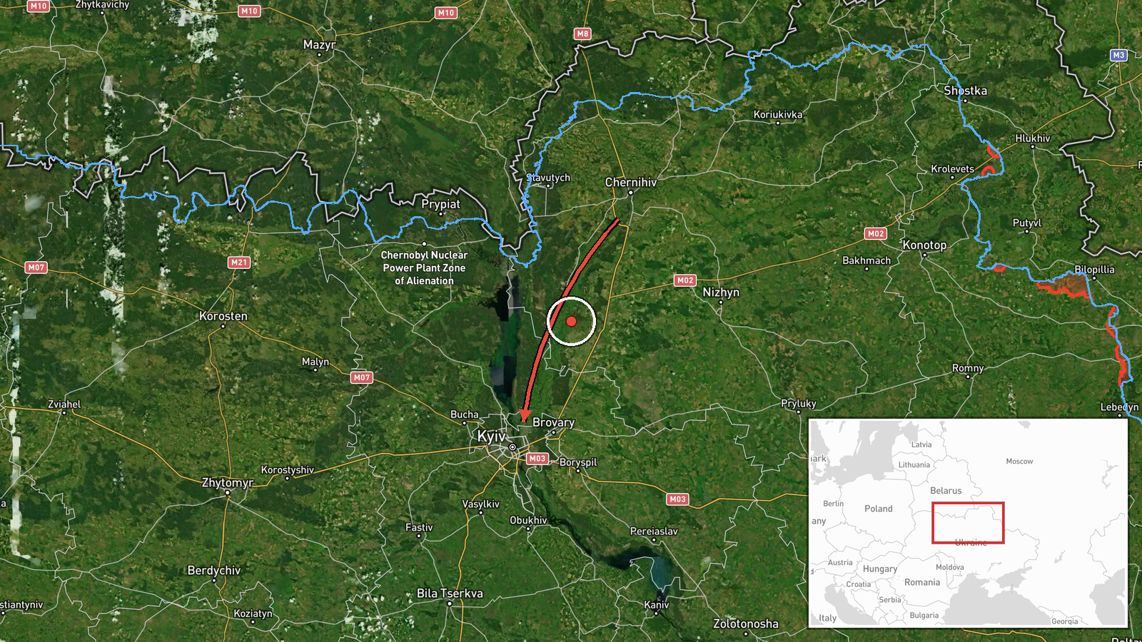
Ukrainian air monitoring reported on Telegram via the channel @kpszsu that one Russian jet-powered Shahed, identified as a Geran-3, was passing the city of Chernihiv on a course toward Kyiv Oblast at about 16:59 UTC on 22 October 2026. The original Ukrainian-language post describes it as a jet-type unmanned aerial vehicle moving past Chernihiv on a heading for the Kyiv region. The report is a transit notice rather than a strike report: it does not describe impact, damage, casualties or interception. The event was recorded from a single channel and has not been independently confirmed by a second source at the time of publication.
Context and assessment
Chernihiv lies in northern Ukraine close to the Belarusian border, and drones entering from that direction often follow corridors that pass north of Kyiv before turning toward the capital or its surrounding oblast. This report sits within a dense sequence of similar transit notices on the same day. Earlier reports from 07:16 and 07:48 UTC described groups of two or more Geran-3 drones from Belarus heading toward Kyiv Oblast. Later reports tracked single drones passing Chabany and over Kyiv city itself between 08:27 and 08:48 UTC, and a further transit near Zhashkiv at 17:00 UTC. Taken together, the pattern suggests a sustained, rolling flow of individual airframes rather than one concentrated salvo. Operationally, staggered single drones of this kind are commonly associated with saturation or probing approaches, with the aim of stretching air defence reaction and radar coverage. Such an inference remains tentative, since the data does not show intent, targets or the number of drones launched.
Sources and confidence
The event rests on one Telegram channel, @kpszsu, which is an official-linked Ukrainian air-monitoring account and has a generally consistent record of such alerts. No second channel is listed as cross-confirming this specific report, although the surrounding related events share similar wording and timing, which lends some coherence to the sequence. The confidence score of 8.0 reflects a credible official-style source with a clear, specific description, offset by the absence of independent confirmation and the transit-only nature of the report. Confidence would rise with corroboration from additional monitoring channels, regional military administration statements or flight-tracking data, and would fall if subsequent reporting contradicted the drone type, direction or timing.
Location
The location is recorded at the oblast level as Kyiv Oblast, with coordinates near 50.45 N, 30.52 E, which places the marker roughly at the Kyiv metropolitan area rather than at the Chernihiv reference point. The location confidence is low and the precision is regional, so the pin should not be read as the drone's exact position. The reported position of the drone was Chernihiv, in the north of Ukraine, with the Desna River and surrounding forest and wetland belts forming the northern approach to the Kyiv region. Kyiv Oblast spans the Dnipro corridor, which is the broad route drones often follow southward toward the capital.
Related events nearby
- Ukrainian air monitoring: 1 Russian jet-powered Shahed (Geran-3) drone passing Zhashkiv, heading toward Kyiv O2026-10-22 17:00 UTC · Drone Transit · Kyiv Oblast, Ukraine
- Ukrainian air monitoring: 1 Russian jet-powered Shahed (Geran-3) drone passing Chabany, heading toward Kyiv.2026-10-22 08:48 UTC · Drone Transit · Kyiv, Ukraine
- Ukrainian air monitoring: 1 Russian jet-powered Shahed (Geran-3) drone over Kyiv.2026-10-22 08:27 UTC · Drone Transit · Kyiv, Ukraine
- Ukrainian air monitoring: 2+ Russian jet-powered Shahed (Geran-3) drones from Belarus toward Kyiv Oblast.2026-10-22 07:48 UTC · Drone Transit · Kyiv Oblast, Ukraine
- Ukrainian air monitoring: 2+ Russian jet-powered Shahed (Geran-3) drones from Belarus toward Kyiv Oblast.2026-10-22 07:16 UTC · Drone Transit · Kyiv Oblast, Ukraine
▶ View this event on the live map

Intel Mapper aggregates open-source reports from monitored Telegram and X channels, geolocates them, cross-checks duplicates across sources and assigns a confidence score. Entries are updated as new confirmations arrive. Read how we verify events.