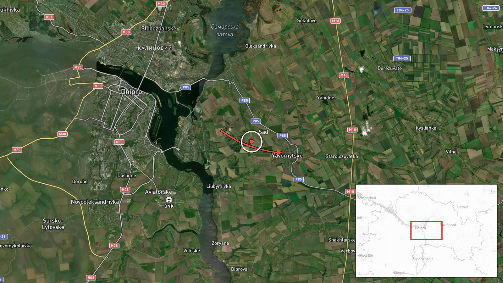
Single Geran-3 jet drone reported heading toward Yavornytske, Dnipropetrovsk Oblast
What happened
Ukraine's air monitoring channel reported on Telegram that one jet-powered Russian Shahed-type drone, identified as Geran-3, was moving toward Yavornytske in Dnipropetrovsk Oblast at about 08:50 UTC on 23 October 2026. The original Ukrainian wording, "Реактивний БпЛА у напрямку Яворницького," describes a jet-powered unmanned aerial vehicle heading toward Yavornytske. It does not specify a launch point, a target, or any impact. The summary lists Dnipropetrovsk Oblast as the origin, but the origin field is empty and the channel's own text does not confirm that. The report contains no casualty, damage, or interception information. It is best read as an air-warning transit notice rather than a confirmed strike on the settlement.
Context and assessment
Yavornytske lies in Dnipropetrovsk Oblast, roughly 15 to 20 kilometres east of Dnipro city based on the coordinates, and the surrounding region has been a recurring corridor for long-range drone traffic. The related reports from the same morning show a dense sequence of Geran-3 transits. Between 05:47 and 06:58 UTC, groups of two or more and then single drones were logged heading toward or over Dnipro. At 07:32 UTC, two or more drones were reported passing the Synelnykove district heading northwest, and at 08:35 UTC a Russian guided glide bomb was reported heading toward Dnipropetrovsk Oblast. Taken together, this pattern suggests a sustained, multi-axis effort across the oblast rather than a single isolated launch. Operationally, drones that pass through a region in sequence are often used to stress air defence, draw interceptors, and probe approach routes. Whether this particular drone was aimed at Yavornytske itself, or was simply transiting toward another objective, cannot be determined from a single short notice.
Sources and confidence
The report comes from one channel, Telegram account @kpszsu, which is associated with Ukraine's air monitoring reporting. No second outlet, official statement, or local impact report appears in the data, so cross-confirmation is absent. The confidence score of 8.0 reflects a credible, institutional-style source with a specific time and a clear track description, offset by the fact that it is single-sourced and states no outcome. Confidence would rise with corroboration from other monitoring channels, regional military administration statements, or reports of debris or impact in the area. It would fall if later updates indicated the track was misidentified or redirected elsewhere.
Location
The location is geocoded at settlement level to Yavornytske, which the source names directly, so the coordinates mark the town centre rather than a specific facility. Location confidence is rated high. The settlement sits in the steppe landscape of central-eastern Ukraine, within Dnipropetrovsk Oblast and the broader Dnipro River basin. Dnipro city, a major urban and industrial centre, lies to the west and is the nearest large reference point in the related reports.
Related events nearby
- Ukrainian air monitoring: 1 Russian guided glide bomb (KAB) heading toward Dnipropetrovsk Oblast.2026-10-23 08:35 UTC · Airstrike · Dnipropetrovsk Oblast, Ukraine
- Ukrainian air monitoring: 1 Russian jet-powered Shahed (Geran-3) drone over Dnipro.2026-10-23 06:58 UTC · Drone Transit · Dnipro, Ukraine
- Ukrainian air monitoring: 1 Russian jet-powered Shahed (Geran-3) drone heading toward Dnipro.2026-10-23 06:44 UTC · Drone Transit · Dnipro, Ukraine
- Ukrainian air monitoring: 2+ Russian jet-powered Shahed (Geran-3) drones heading toward Dnipro.2026-10-23 05:47 UTC · Drone Transit · Dnipro, Ukraine
- Ukrainian air monitoring: 2+ Russian jet-powered Shahed (Geran-3) drones passing Synelnykove district, heading2026-10-23 07:32 UTC · Drone Transit · Synelnykove district, Ukraine
▶ View this event on the live map

Intel Mapper aggregates open-source reports from monitored Telegram and X channels, geolocates them, cross-checks duplicates across sources and assigns a confidence score. Entries are updated as new confirmations arrive. Read how we verify events.