Five Russian Shahed drones tracked transiting toward central Cherkasy Oblast
What happened
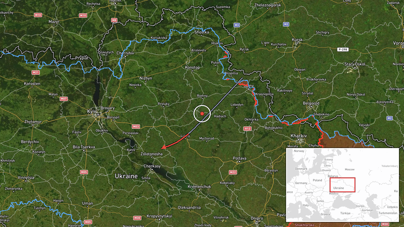
Ukrainian air monitoring detected five Russian reactive (jet-engined) Shahed-variant unmanned aerial vehicles in transit on 24 September at 02:38 UTC. The drones were observed departing the Lubny and Pyriatyn area of Poltava Oblast and heading toward Zolotonosha District in Cherkasy Oblast. The report was published via Telegram by @war_monitor, a Ukrainian air alert channel, indicating ongoing drone operations across central Ukraine.
Context and assessment
This transit event occurred amid an intense Russian drone campaign targeting central Ukraine. On the preceding night of 23–24 September, Ukrainian air defense reportedly engaged 122 enemy targets, predominantly Shahed and Geran drones, from a larger strike package of 161 total aircraft. Multiple related drone transits were documented over the same period across Kyiv, Kyiv Oblast, and Cherkasy Oblast, suggesting a coordinated or sustained offensive wave. Zolotonosha District lies in a corridor frequently targeted by Russian drone strikes; the concentration of tracked transits in this region may indicate preparation for strikes on infrastructure, military positions, or logistics nodes in central Cherkasy Oblast.
Sources and confidence
Single source: Telegram channel @war_monitor, which monitors Ukrainian air defense alerts and drone activity. No cross-confirmation from Ukrainian official military channels or independent verification reported. Confidence score of 6.0 reflects reliance on a single open-source channel with established credibility for air monitoring but without secondary confirmation. Score could increase with corroboration from official SBU/General Staff statements or impact reports.
Location
Zolotonosha District, Cherkasy Oblast, central Ukraine (49.67°N, 32.04°E). The transit route began in northern Poltava Oblast (Lubny–Pyriatyn area, ~80 km north) and tracked southwestward into Zolotonosha District along a known drone corridor. The region straddles the Dnipro River valley; Zolotonosha serves as a logistical hub and contains infrastructure of military and civilian importance.
Related events nearby
- Ukrainian air monitoring reports 3 Russian reactive (jet-engined) Shahed variant UAVs transiting over Cherkasy2026-09-24 02:37 UTC · Drone Transit · Cherkasy Oblast, Ukraine
- Russian Shahed-136 reactive (jet-motorized) kamikaze drone detected in transit over Lukyyanivka/Shulyavka dist2026-09-23 04:26 UTC · Drone Transit · Lukyyanivka District, Kyiv, Ukraine
- Russian Shahed-type (reactive) drone transited from Kaniv toward Obukhiv District, Kyiv Oblast. Air alert main2026-09-23 13:11 UTC · Drone Transit · Obukhiv District, Kyiv Oblast, Ukraine
- Ukrainian air monitoring detected 2 Russian reactive (jet-engined) Shahed-variant UAVs transiting over Mirhhor2026-09-24 03:38 UTC · Drone Transit · Mirhhorod, Poltava Oblast, Ukraine
- Ukrainian air defense destroyed/suppressed 122 enemy targets (119 Shahed/Geran drones, 3 cruise missiles) duri2026-09-23 05:34 UTC · Report · Central Ukraine
▶ View this event on the live map
Intel Mapper aggregates open-source reports from monitored Telegram and X channels, geolocates them, cross-checks duplicates across sources and assigns a confidence score. Entries are updated as new confirmations arrive. Read how we verify events.