Ukrainian monitors report a Russian Banderol cruise missile heading toward Zolotonosha district
What happened
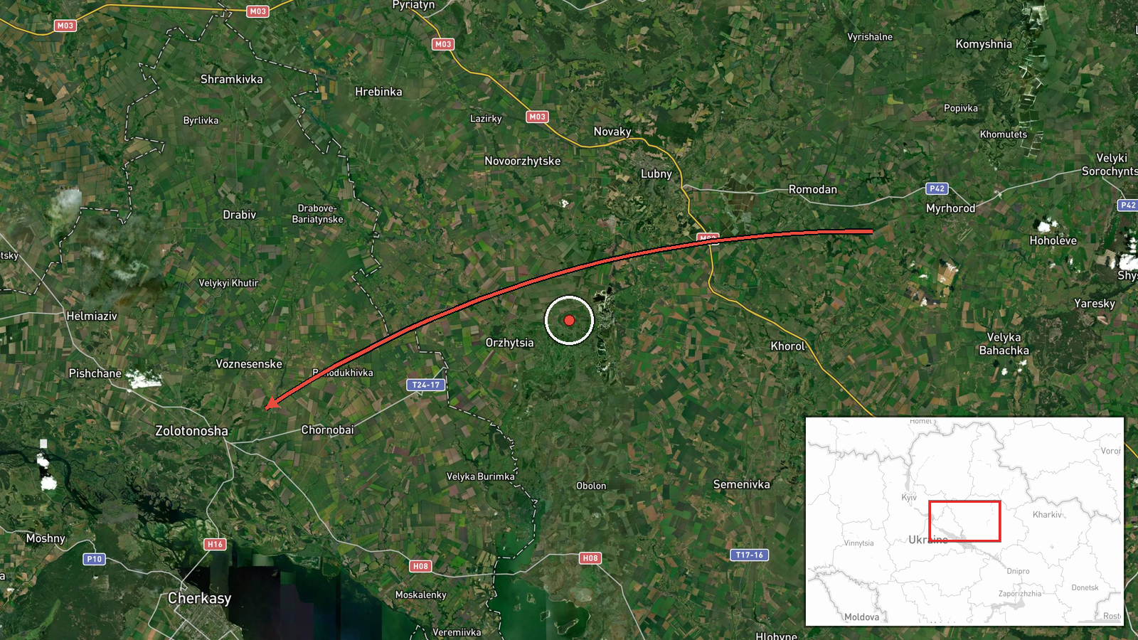
Ukrainian air monitoring reported at 19:19 UTC on 18 October 2026 that one Russian Banderol mini cruise missile was passing Myrhorod in Poltava region and heading toward the Zolotonosha district of Cherkasy region. The original Ukrainian-language Telegram post, published by the channel @war_monitor, uses the phrase 'vector toward Cherkasy region' to describe the track. The report describes no impact, damage, casualties, or interception. It is a single-source alert, and the summary is an interpretation of that post. Timing and direction are consistent with a missile in flight, so the listed location marks the heading's destination area, not a verified strike point.
Context and assessment
Zolotonosha sits in central Ukraine on the Cherkasy side of the Poltava-Cherkasy border, an area repeatedly crossed by Russian long-range air activity aimed at logistics, energy, and industrial sites across the wider Dnipro basin. Its relevance to a missile track lies less in a single fixed asset than in the corridor it occupies, with routes running north-east to south-west linking Poltava, the Kremenchuk area, and Cherkasy. The related events show a dense pattern that night. A Banderol was logged over Zolotonosha district at 18:48 UTC, and five minutes later another was reported heading toward Korsun-Shevchenkivskyi, a town to the south-west. Earlier, a Shahed-type drone was tracked toward Cherkasy at 02:02, and a separate warning flagged Russian tactical aviation activity and a threat of aviation-launched strike weapons to frontline oblasts. Operationally, a sequence of small cruise missiles on successive, nearby headings may indicate a sustained strike package or a deliberate probe of air defence coverage, though the data alone cannot distinguish these. The convoy report about soldiers withdrawn from the front names no location and shows no evident link to the missile activity.
Sources and confidence
The report rests on a single Telegram channel, @war_monitor, which is the only listed source. No independent channel, official statement, or second monitoring feed in the dataset corroborates the track, so cross-confirmation is absent. The confidence score of 6.0 reflects a plausible monitoring-type post with a specific, time-stamped track and a recognisable weapon type, offset by single-sourcing and the lack of any impact or interception detail. Confidence would rise with a second air monitoring source or a regional military administration statement, and would fall if the track is later revised, reattributed to another system, or shown to be a non-event.
Location
The coordinates correspond to Zolotonosha, a town-level settlement, so geographic precision is recorded as settlement rather than a specific facility. The point marks the town itself rather than the missile's position, because the source gives a heading rather than a fixed location. The area is flat, lightly wooded steppe, with the Dnipro valley and its reservoirs lying to the east. Location confidence is high for the settlement, but any inference about the missile's ultimate destination is considerably less certain.
Related events nearby
- Ukrainian air monitoring: 1 Russian Banderol mini cruise missile over Zolotonosha district.2026-10-18 18:48 UTC · Cruise Missile · Zolotonosha district, Ukraine
- Ukrainian air monitoring: 1 Russian Banderol mini cruise missile passing Myrhorod, heading toward Cherkasy Obl2026-10-18 19:37 UTC · Cruise Missile · Cherkasy Oblast, Ukraine
- Ukrainian air monitoring: 1 Russian Shahed-type drone heading toward Cherkasy.2026-10-18 02:02 UTC · Drone Transit · Cherkasy, Ukraine
- Ukrainian air monitoring preliminary reconnaissance on Russian Banderol mini cruise missiles; no specific loca2026-10-18 19:45 UTC · Cruise Missile · Ukraine (location not reported)
- Ukrainian soldiers who served on the front line for a long period have been withdrawn from their positions. No2026-10-18 00:00 UTC · Convoy · Ukraine (location not reported)
▶ View this event on the live map

Intel Mapper aggregates open-source reports from monitored Telegram and X channels, geolocates them, cross-checks duplicates across sources and assigns a confidence score. Entries are updated as new confirmations arrive. Read how we verify events.