Single Russian Banderol mini cruise missile tracked over Poltava region toward Cherkasy Oblast
What happened
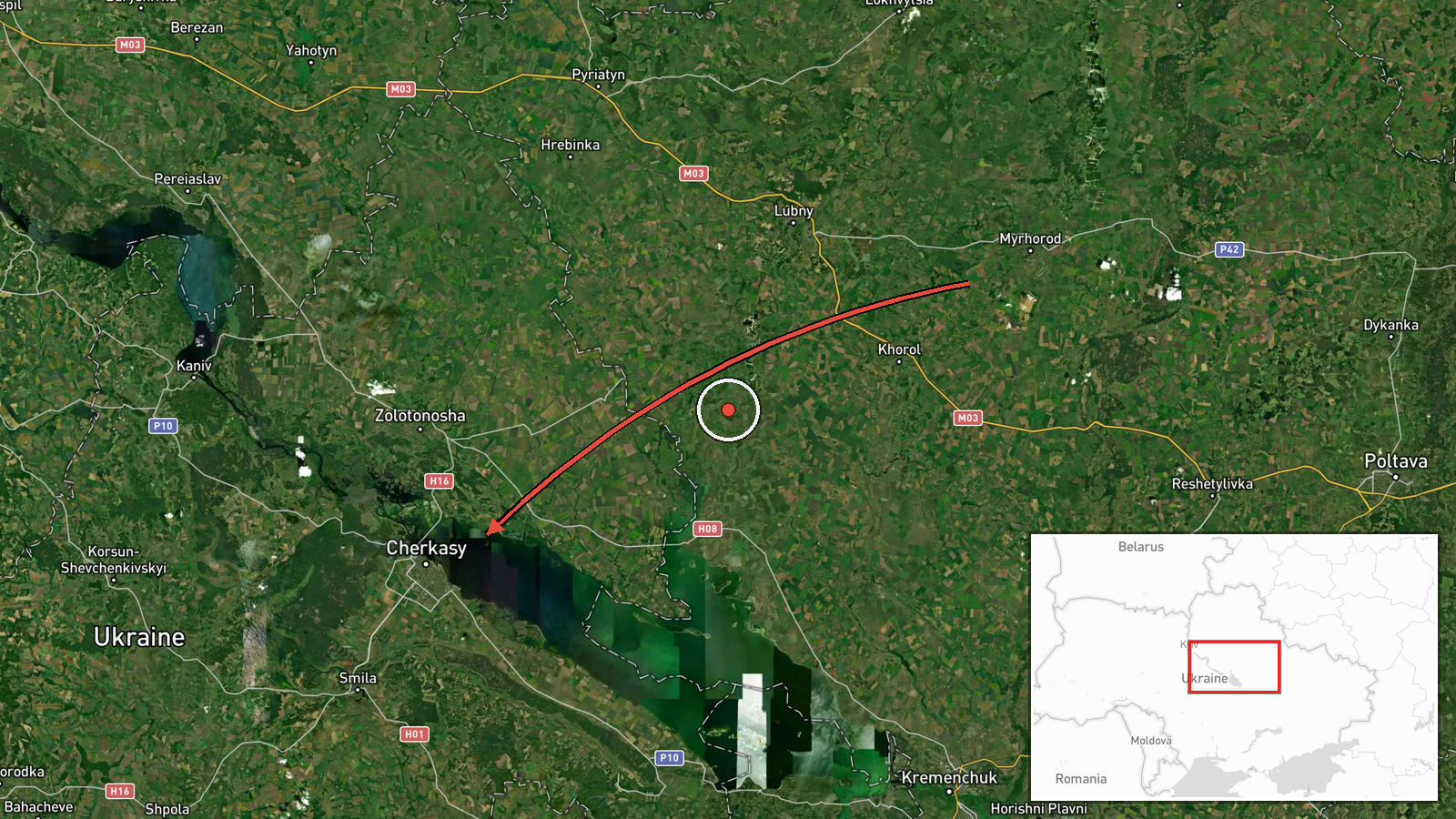
Ukrainian air monitoring channel Telegram (@war_monitor) reported on 18 October 2026, at about 19:37 UTC, that one Russian Banderol mini cruise missile was passing Myrhorod in Poltava region and heading in the direction of Cherkasy Oblast. The original Ukrainian-language post is brief, labelling the item under a Poltava heading and noting only the direction of travel. It gives no impact point, no damage report and no official confirmation. The alert is one of several Banderol-related notices logged the same evening in the same general area, and the monitoring channel's wording reflects a track rather than a confirmed strike. Because the report describes a flight path and not an observed detonation, the event should be read as a reported airborne track.
Context and assessment
Myrhorod sits in central Poltava region, and the route from there toward Cherkasy Oblast crosses the Dnipro basin's agricultural and river-valley terrain, an axis that has repeatedly carried Russian long-range and small cruise munitions toward central Ukrainian districts. The related events show a sequence over several hours. A Shahed-type drone was reported heading toward Cherkasy in the early hours, a Banderol was reported over Zolotonosha district at 18:48 UTC, and a later alert described a Banderol passing Myrhorod toward Zolotonosha at 19:19 UTC. The present report, at 19:37 UTC, continues the same pattern of a low-flying missile moving along a north-south corridor. Operationally, a cluster like this may suggest repeated probing or a deliberate effort to stretch air defence across several districts rather than a single targeted strike, though the data cannot establish intent. The Banderol is a small, low-altitude cruise missile whose reduced radar signature makes early tracking difficult, which is why monitoring channels frequently report it as passing over settlements. An unlocated preliminary-reconnaissance entry at 19:45 UTC adds to the picture but does not clarify the target.
Sources and confidence
The event rests on one Telegram channel, @war_monitor, with no second outlet cross-confirming the track. The report is a short alert that relies on real-time observation and is not corroborated by Ukrainian air force statements in the provided data. Confidence is scored at 6.0 out of 10, reflecting a credible monitoring source with a clear direction of travel but no independent verification, no impact report and no time-stamped sensor data. Confidence would rise if the Ukrainian air force or regional military administrations confirmed the track, if a second independent monitor reported it, or if impact or debris was documented. It would fall if later reporting showed the track was misidentified or referred to a different munition.
Location
The location is recorded at region level, Cherkasy Oblast, with approximate coordinates of 49.44 N, 32.06 E, and location confidence is rated low. The coordinates do not mark a specific settlement or facility and are best read as a regional centroid rather than a point of impact. The source names Myrhorod as a waypoint in Poltava region and Cherkasy as the heading. The area is largely flat, drained by the Dnipro and its tributaries, with farmland, forest belts and scattered rail and road links, and the nearby Cherkasy and Zolotonosha districts are the main settlements referenced.
Related events nearby
- Ukrainian air monitoring: 1 Russian Shahed-type drone heading toward Cherkasy.2026-10-18 02:02 UTC · Drone Transit · Cherkasy, Ukraine
- Ukrainian air monitoring: 1 Russian Banderol mini cruise missile passing Myrhorod, heading toward Zolotonosha 2026-10-18 19:19 UTC · Cruise Missile · Zolotonosha district, Ukraine
- Ukrainian air monitoring: 1 Russian Banderol mini cruise missile over Zolotonosha district.2026-10-18 18:48 UTC · Cruise Missile · Zolotonosha district, Ukraine
- Ukrainian air monitoring preliminary reconnaissance on Russian Banderol mini cruise missiles; no specific loca2026-10-18 19:45 UTC · Cruise Missile · Ukraine (location not reported)
- Ukrainian soldiers who served on the front line for a long period have been withdrawn from their positions. No2026-10-18 00:00 UTC · Convoy · Ukraine (location not reported)
▶ View this event on the live map

Intel Mapper aggregates open-source reports from monitored Telegram and X channels, geolocates them, cross-checks duplicates across sources and assigns a confidence score. Entries are updated as new confirmations arrive. Read how we verify events.