Single Banderol cruise missile reported passing Romny toward Pryluky, Ukraine
What happened
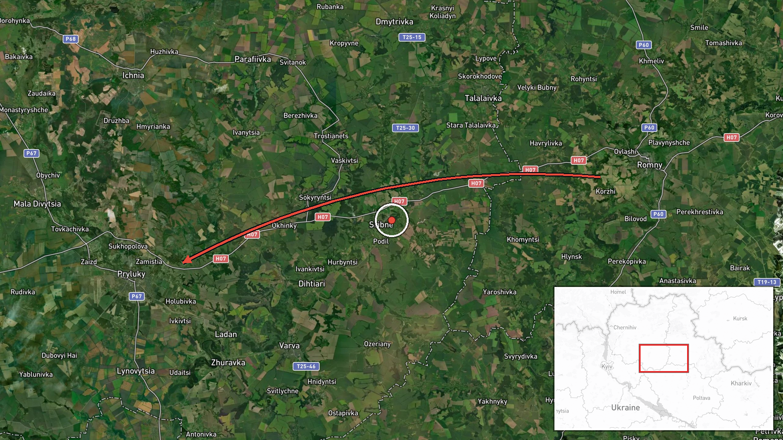
Ukrainian air monitoring reported on 18 October 2026 at 19:19 UTC that one Russian Banderol mini cruise missile was passing Romny, in Sumy Oblast, on a heading toward Pryluky in Chernihiv Oblast. The original Ukrainian-language post, published on a Telegram channel labelled @war_monitor, is brief: it names the Sumy region as a header and states that a Banderol was passing Romny in the direction of Pryluky. The post gives no altitude, no impact report and no information about whether the missile was intercepted or reached its destination. The entry is therefore best read as a transit observation rather than a confirmed strike, and it had not been corroborated by a second channel at the time of logging.
Context and assessment
Pryluky is a regional town in northeastern Ukraine, and its position on approach routes from the Russian border makes it a recurring point in air-monitoring reports. The track described runs through the Sumy and Chernihiv corridor, an axis Ukrainian monitors have followed repeatedly since 2022. Related events logged earlier the same day show a wider pattern. At 06:04 UTC a jet-powered Shahed, reported as a Geran-3, was heading toward Velyka Dymerka. At 07:36 UTC another was reported moving from northern Chernihiv Oblast toward Mena, at 07:46 UTC one passed Kulykivka heading south, and at 07:53 UTC a Banderol was reported over Mena. This sequence suggests drones and cruise missiles were being tracked through the same northern region within a few hours. A separate Banderol track carries the same 19:19 timestamp, described as passing Myrhorod toward the Zolotonosha district, so the reports may describe more than one missile in central Ukraine or overlapping observations of one wider activity. Operationally, such tracks are generally consistent with launches aimed at targets further south or west, though the data does not identify a specific target.
Sources and confidence
The report rests on one Telegram channel, @war_monitor, and no second source is listed. The confidence score of 6.0 reflects a single-channel report that appears to relate to a live air-monitoring feed but has not been independently verified. It is not higher because no second channel, official Ukrainian statement, or imagery confirms the track, and because the post gives a direction rather than a confirmed impact. Confidence would rise if an official air force or regional military statement confirmed the track, if other monitoring channels reported matching positions, or if interception or impact were documented. It would fall if the track were later tied to a different date or missile, or to a misreading of the route.
Location
The location is a settlement-level match to Pryluky, Ukraine, at approximately 50.595 N, 32.384 E, rated high confidence. The coordinates mark the town itself rather than a facility, and the post names Pryluky as the direction of travel, not a point of impact. Pryluky lies in Chernihiv Oblast on flat northeastern lowland of river valleys and farmland, on the Udy River. Romny, where the missile was reported passing, lies to the northeast in Sumy Oblast.
Related events nearby
- Ukrainian air monitoring: 2 Russian Banderol mini cruise missiles over Pryluky.2026-10-18 19:34 UTC · Cruise Missile · Pryluky, Ukraine
- Ukrainian air monitoring: 1 Russian jet-powered Shahed (Geran-3) drone passing Kulykivka, heading south.2026-10-18 07:46 UTC · Drone Transit · Kulykivka, Ukraine
- Ukrainian air monitoring: 1 Russian Banderol mini cruise missile over Mena.2026-10-18 07:53 UTC · Cruise Missile · Mena, Ukraine
- Ukrainian air monitoring: 1 Russian jet-powered Shahed (Geran-3) drone from northern Chernihiv Oblast toward M2026-10-18 07:36 UTC · Drone Transit · Mena, Ukraine
- Ukrainian air monitoring: 1 Russian jet-powered Shahed (Geran-3) drone heading toward Velyka Dymerka.2026-10-18 06:04 UTC · Drone Transit · Velyka Dymerka, Ukraine
▶ View this event on the live map

Intel Mapper aggregates open-source reports from monitored Telegram and X channels, geolocates them, cross-checks duplicates across sources and assigns a confidence score. Entries are updated as new confirmations arrive. Read how we verify events.