Russian Geran-3 drone tracked over central Ukraine in overnight strike wave
What happened
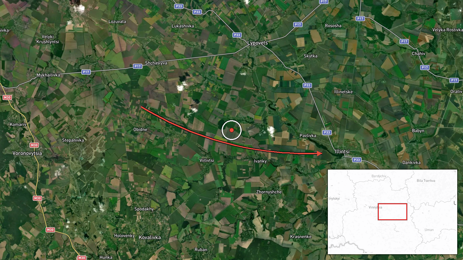
Ukrainian air monitoring reported a single Russian jet-powered Shahed drone (Geran-3 variant) transiting over Illintsi in Vinnytsia Oblast at 02:09 UTC on 15 October 2026. The drone was tracked approaching from the east. The report comes from the official Telegram channel of Ukraine's air command (kpszsu), which monitors Russian air activity across Ukrainian airspace in real time.
Context and assessment
The sighting is part of a wider Russian drone operation spanning central Ukraine overnight, with Geran-3 drones detected near Voronovytsya, Tyvriv, Uzyn, and Zhytomyr Oblast within minutes of the Illintsi report. Geran-3 drones are jet-powered cruise missiles with extended range and loiter capability, typically used for strikes on infrastructure and civilian areas. The concentration of multiple drone tracks across Vinnytsia and adjacent regions suggests either a coordinated multi-target strike or a dispersed salvo. Illintsi lies in a corridor between Vinnytsia city and the Dnieper, an area of repeated Russian drone and missile targeting.
Sources and confidence
Reported solely by the official Telegram channel of Ukraine's Air Force command (kpszsu), a primary source for air activity monitoring. No cross-confirmation from independent monitors or Ukrainian military statements provided. Confidence score of 8.0 reflects official Ukrainian source credibility but single-source constraint. Confirmation by secondary Ukrainian channels or Russian claim would raise confidence; absence of follow-up reporting on impact would lower it slightly.
Location
Illintsi is a settlement in central Vinnytsia Oblast, approximately 35 km east of Vinnytsia city and 15 km west of the Dnieper River. The location sits at coordinates 49.10544°N, 29.20589°E, determined at settlement-level precision. The area is predominantly agricultural with scattered settlements along regional highways connecting Vinnytsia to Kyiv and the north.
Related events nearby
- Ukrainian air monitoring: 1 Russian jet-powered Shahed (Geran-3) drone from Vinnytsia Oblast toward Voronovyts2026-10-15 02:16 UTC · Drone Transit · Voronovytsya, Ukraine
- Ukrainian air monitoring: 1 Russian jet-powered Shahed (Geran-3) drone from Vinnytsia Oblast toward Tyvriv.2026-10-15 02:22 UTC · Drone Transit · Tyvriv, Ukraine
- Ukrainian air monitoring: 1 Russian jet-powered Shahed (Geran-3) drone heading toward Uzyn.2026-10-15 02:27 UTC · Drone Transit · Uzyn, Ukraine
- Ukrainian air monitoring: 1 Russian jet-powered Shahed (Geran-3) drone heading toward Fastiv.2026-10-15 02:32 UTC · Drone Transit · Fastiv, Ukraine
- Russian jet-powered Shahed (Geran-3) drone tracked transiting from northern Zhytomyr Oblast toward northern Ri2026-10-15 01:52 UTC · Drone Transit · Zhytomyr Oblast, Ukraine
▶ View this event on the live map

Intel Mapper aggregates open-source reports from monitored Telegram and X channels, geolocates them, cross-checks duplicates across sources and assigns a confidence score. Entries are updated as new confirmations arrive. Read how we verify events.