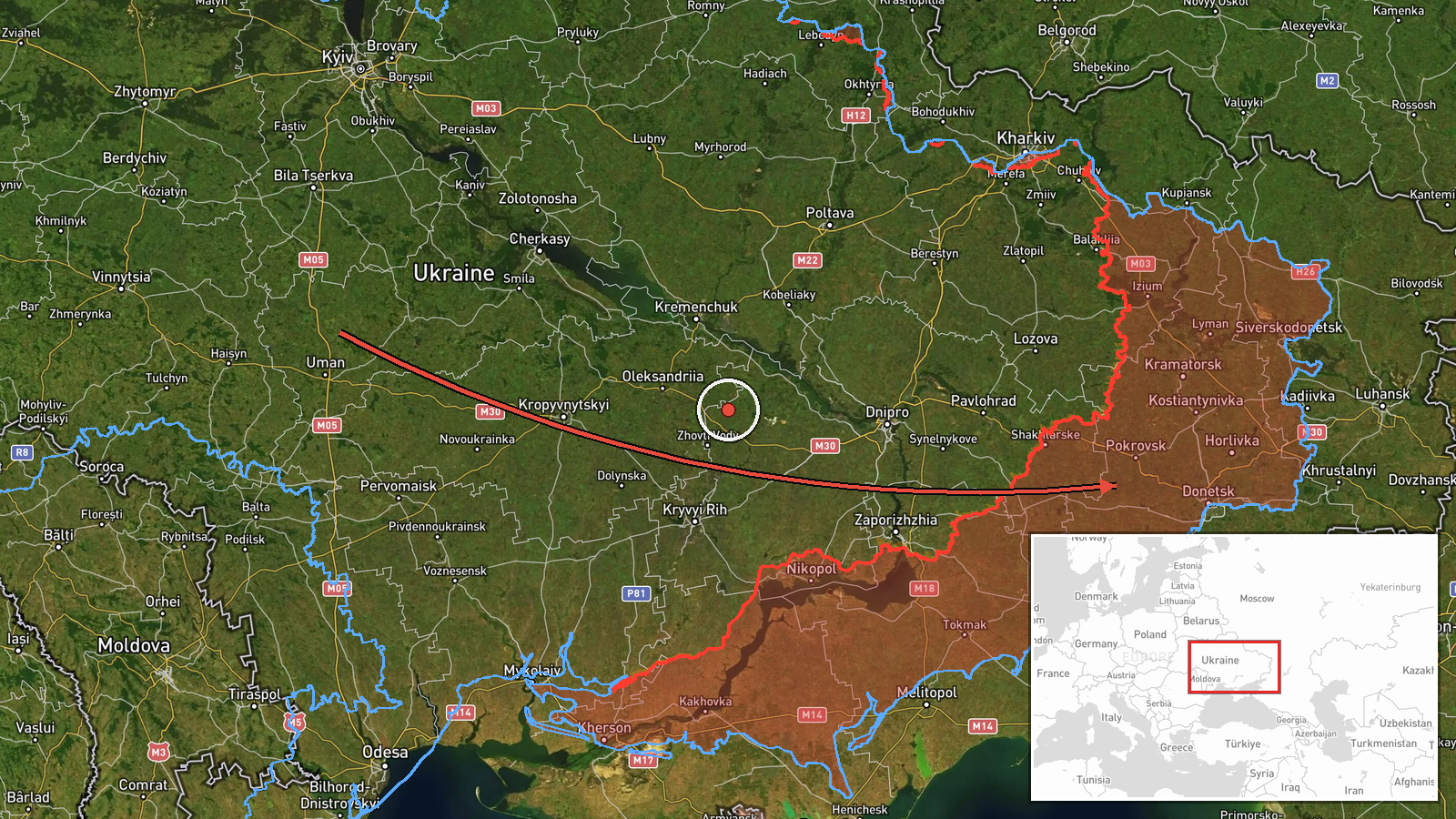
Russian Geran-3 drone transits central Ukraine toward Kalynivskyi
What happened
Ukrainian air monitoring detected one Russian jet-powered Shahed (Geran-3) unmanned aerial vehicle in Vinnytsia Oblast on a westward trajectory toward Kalynivskyi on October 15 at 09:18 UTC. The report was posted to the Kyiv Post Air Defense Telegram channel, which aggregates real-time Ukrainian air-defence observations. Kalynivskyi is a settlement in central Ukraine approximately 180 kilometers west of the Russian border.
Context and assessment
Kalynivskyi lies in a region where Ukrainian forces have recently made territorial gains. On October 14, Ukrainian forces reportedly liberated both Zelena Dolyna and Kolodiazi, recapturing roughly 89 square kilometers in the Zelena Dolyna sector. The Geran-3, a jet-powered variant of the Shahed family, is Russia's longest-range attack drone, capable of strikes deep into Ukrainian territory. This October 15 sighting is part of a broader pattern: a similar drone was detected transiting Lazurnyi earlier that morning heading west, and another passed Blyzniuky in Kharkiv Oblast on October 15 at 03:35 UTC. The repeated use of these aircraft over central Ukraine suggests sustained Russian operations targeting rear-area infrastructure or military positions.
Sources and confidence
Report sourced solely from Kyiv Post Air Defense Telegram channel (@kpszsu), an aggregator of Ukrainian official air-defence monitoring. Single-source reporting with no cross-confirmation from other channels lowers confidence moderately. Confidence score of 8.0 reflects the channel's established track record in real-time air observations but the absence of independent verification. Corroboration from other Ukrainian air-defence accounts or international radar data would strengthen confidence.
Location
Kalynivskyi is a settlement in Vinnytsia Oblast, central Ukraine, at approximately 48.01°N, 37.85°E. It lies roughly 180 kilometers southwest of the Russia–Ukraine border and sits in a region of ongoing ground combat and recent Ukrainian territorial recovery. Nearby Zelena Dolyna, liberated October 14, is approximately 40 kilometers to the south-southwest.
Related events nearby
- Ukrainian air monitoring: 1 Russian jet-powered Shahed (Geran-3) drone passing Lazurnyi, heading west.2026-10-15 07:24 UTC · Drone Transit · Lazurnyi, Ukraine
- Kolodiazi reported liberated by Ukrainian forces (per DeepStateMAP frontline update).2026-10-14 12:20 UTC · Capture · Kolodiazi
- Ukrainian forces regained ground (~89 km²) in the Zelena Dolyna sector per DeepState frontline update. No sett2026-10-14 12:20 UTC · Combat · Zelena Dolyna sector, Ukraine
- Zelena Dolyna reported liberated by Ukrainian forces (per DeepStateMAP frontline update).2026-10-14 12:20 UTC · Capture · Zelena Dolyna
- Ukrainian air monitoring: 2+ Russian jet-powered Shahed (Geran-3) drones over east of Pavlohrad.2026-10-15 09:52 UTC · Drone Transit · east of Pavlohrad, Ukraine
▶ View this event on the live map

Intel Mapper aggregates open-source reports from monitored Telegram and X channels, geolocates them, cross-checks duplicates across sources and assigns a confidence score. Entries are updated as new confirmations arrive. Read how we verify events.