Russian Geran-3 drone tracked toward Dubno in northwestern Ukraine
What happened
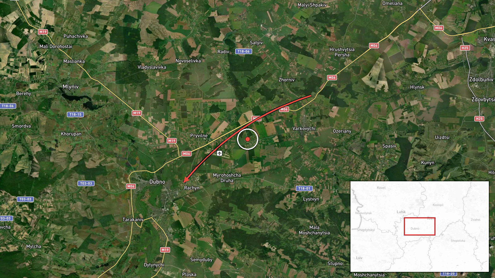
Ukrainian air monitoring reported a single Russian jet-powered Shahed (Geran-3) drone transiting through Rivne Oblast with a course toward Dubno on the morning of October 15, 2026. The sighting was logged at 09:56 UTC. The report came via the official Telegram channel of Ukraine's Air Force command (@kpszsu). No immediate interception or impact was reported in the available data.
Context and assessment
Dubno is a regional hub in northwestern Ukraine's Rivne Oblast, roughly 290 kilometers west of Kyiv. The sighting is part of a sustained pattern of Russian drone activity across the northwestern approaches that began early on October 15, with at least five separate Geran-3 transits tracked between 01:52 and 09:56 UTC. Earlier reports show drones departing from Khmelnytskyi Oblast, passing through Olevsk, and flowing into Rivne Oblast before heading toward Dubno. Geran-3s are jet-powered reconnaissance or strike variants of the Iranian-origin Shahed family, typically used for standoff attacks on infrastructure or military positions. The repetitive routing through this corridor may indicate either a concentrating attack wave or ongoing reconnaissance of northwestern targets.
Sources and confidence
Source is the official Telegram channel of Ukraine's Air Force Command (@kpszsu), which publishes real-time air monitoring alerts. This report represents a single independent channel with no cross-confirmation from other outlets in the available data. Confidence is moderate (8.0/10) due to the official Ukrainian source and consistency with the broader pattern of drone transits on the same date, but the absence of secondary confirmation limits certainty on the specific vector and intended target.
Location
Dubno is a city in Rivne Oblast, northwestern Ukraine, situated approximately 290 kilometers west-northwest of Kyiv. It serves as an administrative and transportation hub in the region. The location was identified at settlement-level precision (50.41°N, 25.76°E) with high confidence. Nearby terrain is relatively open agricultural land with scattered forests typical of Polesia.
Related events nearby
- Ukrainian air monitoring: 1 Russian jet-powered Shahed (Geran-3) drone from Khmelnytskyi Oblast toward Rivne O2026-10-15 09:48 UTC · Drone Transit · Rivne Oblast, Ukraine
- Ukrainian air monitoring: 2+ Russian jet-powered Shahed (Geran-3) drones passing Olevsk, heading toward Rivne 2026-10-15 07:47 UTC · Drone Transit · Rivne Oblast, Ukraine
- Ukrainian air monitoring: 1 Russian jet-powered Shahed (Geran-3) drone heading toward Rivne.2026-10-15 02:29 UTC · Drone Transit · Rivne, Ukraine
- Ukrainian air monitoring: 1 Russian jet-powered Shahed (Geran-3) drone passing Rivne Oblast, heading southwest2026-10-15 01:54 UTC · Drone Transit · Rivne Oblast, Ukraine
- Ukrainian air monitoring: 1 Russian jet-powered Shahed (Geran-3) drone heading toward Rivne.2026-10-15 01:52 UTC · Drone Transit · Rivne, Ukraine
▶ View this event on the live map

Intel Mapper aggregates open-source reports from monitored Telegram and X channels, geolocates them, cross-checks duplicates across sources and assigns a confidence score. Entries are updated as new confirmations arrive. Read how we verify events.