Single jet-powered Shahed drone reported moving toward Slavutych from northern Chernihiv Oblast
What happened
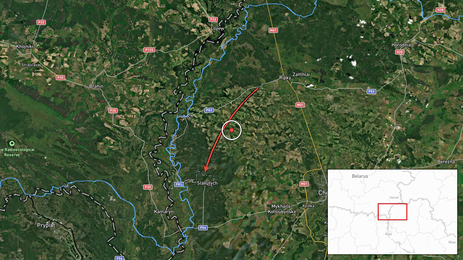
Ukrainian air monitoring channel @kpszsu reported on 16 October 2026 at about 06:54 UTC that one Russian jet-powered Shahed (Geran-3) drone was moving from northern Chernihiv Oblast toward the city of Slavutych, in northern Ukraine. The original Ukrainian-language post described it as a jet-type unmanned aerial vehicle on a course toward Slavutych, a wording that indicates a transit track rather than a confirmed strike. The report names no impact point, damage, or casualties. The event is recorded from a single Telegram source, so the track and the drone's type rest on that channel's monitoring and have not been independently confirmed.
Context and assessment
Slavutych sits in northern Ukraine near the Chernihiv and Kyiv oblast borders and is a town of concern because of its proximity to the Chornobyl Exclusion Zone and to the Dnipro corridor used by drones flying in from the north. The related events form a clear pattern. On 15 October 2026, monitoring logged a sequence of single and multiple Geran-3 transits in the same area: a group of two or more over Chernihiv at 15:38 UTC, a single drone at Ripky heading southwest at 10:39, a drone crossing the Chornobyl Exclusion Zone heading west at 08:55, and further single drones over Chornobyl at 10:57 and heading toward Chernihiv at 17:08. Taken together, this suggests a corridor of repeated drone movement across the region over roughly a day, with Slavutych as a later point on a similar track. Operationally, such transits are typically associated with route probing, reconnaissance, or distraction and air-defence stretching rather than with any single fixed target, though intent cannot be established from a transit report alone.
Sources and confidence
The event rests on one Ukrainian Telegram channel, @kpszsu, which publishes official air-monitoring alerts. No second outlet, official statement, or local confirmation appears in the record. The confidence score of 8.0 reflects a credible, routinely used monitoring source and a consistent pattern with several same-day reports in the area, but it is held below the top range because the source count is one and no independent verification exists. Confidence would rise with corroboration from another monitoring channel, regional authorities, or a later report of impact. It would fall if subsequent alerts contradicted the track or if the drone was later reported as lost or diverted.
Location
The location is recorded at settlement level for Slavutych, Ukraine, with a high location confidence rating, and the coordinates correspond to the town centre rather than a specific facility. The source names only the town as the destination, so the point is an approximation of the target area rather than a verified site. Slavutych lies in northern Ukraine on the Desna and Dnipro river systems, close to the Chornobyl Exclusion Zone to its west and north, and it is surrounded by forest and low-lying wetland terrain typical of the Polissia region.
Related events nearby
- Ukrainian air monitoring: 2+ Russian jet-powered Shahed (Geran-3) drones over Chernihiv.2026-10-15 15:38 UTC · Drone Transit · Chernihiv, Ukraine
- Ukrainian air monitoring: 1 Russian jet-powered Shahed (Geran-3) drone heading toward Chernihiv.2026-10-15 17:08 UTC · Drone Transit · Chernihiv, Ukraine
- Ukrainian air monitoring: 2+ Russian jet-powered Shahed (Geran-3) drones passing Ripky, heading southwest.2026-10-15 10:39 UTC · Drone Transit · Ripky, Ukraine
- Ukrainian air monitoring reports 1 Russian jet-powered Shahed (Geran-3) drone transiting through Chornobyl Exc2026-10-15 08:55 UTC · Drone Transit · Chornobyl Exclusion Zone, Kyiv Oblast, Ukraine
- Ukrainian air monitoring: 1 Russian jet-powered Shahed (Geran-3) drone over Chornobyl.2026-10-15 10:57 UTC · Drone Transit · Chornobyl, Ukraine
▶ View this event on the live map

Intel Mapper aggregates open-source reports from monitored Telegram and X channels, geolocates them, cross-checks duplicates across sources and assigns a confidence score. Entries are updated as new confirmations arrive. Read how we verify events.