Single Shahed-type drone reported moving through Vinnytsia Oblast toward Voronovytsya
What happened
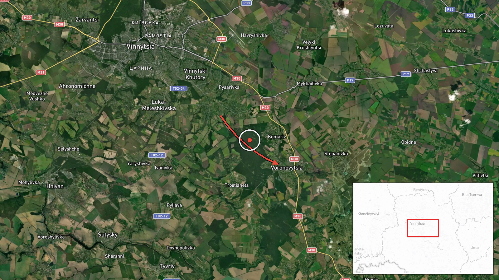
Ukrainian air monitoring reported on 16 October 2026 at about 15:27 UTC that one Russian Shahed-type drone was tracked from Vinnytsia Oblast toward the settlement of Voronovytsya. The original Ukrainian-language post, carried by the Telegram channel @kpszsu, describes it as a strike drone approaching Voronovytsya from the east, using the phrase "ударний БПлА" (strike unmotorized aerial vehicle, a common term for attack drones). The report does not state whether the drone struck anything, what it targeted, or whether any damage or casualties occurred. The post is a monitoring alert rather than a damage report, and it is the only source listed for this event.
Context and assessment
Vinnytsia Oblast lies in central-west Ukraine and has become a recurring corridor for drones heading further west, toward the Zhytomyr and Khmelnytskyi regions and onward toward the Polish and Romanian borders. The related events logged that same afternoon show a dense sequence: a drone moving from Odesa Oblast toward Vinnytsia at 12:28, a single drone over the city of Vinnytsia at 14:31, a group of at least two jet-powered Geran-3 drones passing westward at 14:32, and further single drones heading toward Zhytomyr Oblast at 14:40. An earlier alert at 05:23 described a jet-powered drone toward Nemyriv, a town in the same oblast. Taken together, the pattern suggests a sustained transit route rather than a single isolated attack. Voronovytsya is a small settlement, so the report most likely reflects a drone being tracked along a heading that passes near it, not a deliberate target selection that can be confirmed from this data. Operationally, repeated tracks across the same oblast may indicate long-range flights designed to stretch air defense and early-warning coverage, though the reporting alone cannot establish intent.
Sources and confidence
The event rests on one Telegram channel, @kpszsu, which is the Ukrainian air force-linked monitoring feed commonly used for real-time drone tracking. No second outlet or official statement in the dataset independently confirms this specific track. The confidence score of 8.0 reflects a credible, specialized channel with a consistent reporting format and a corroborating sequence of nearby alerts on the same afternoon, but it is held below the top of the scale because there is no independent cross-confirmation and the report does not describe impact. Confidence would rise with a second monitoring source, regional military administration confirmation, or an official impact report. It would fall if the track were later revised, corrected, or shown to be a different aircraft.
Location
The location is placed at the settlement level for Voronovytsya, a small community in Vinnytsia Oblast, with coordinates of approximately 49.109 N, 28.687 E, and the location confidence is recorded as high. The position is not a facility and is not derived from an impact site. Geographically, the area lies in the rolling farmland of the Podolia region, drained by the Southern Bug river system to the south and west of the oblast's main axes. The nearby city of Vinnytsia lies to the northwest and is the most prominent reference point for the surrounding flight corridor.
Related events nearby
- Ukrainian air monitoring: 1 Russian jet-powered Shahed (Geran-3) drone from Vinnytsia Oblast toward Nemyriv.2026-10-16 05:23 UTC · Drone Transit · Nemyriv, Ukraine
- Ukrainian air monitoring: 1 Russian Shahed-type drone passing Vinnytsia Oblast, heading west; 1 Russian Shahed2026-10-16 14:40 UTC · Drone Transit · Vinnytsia Oblast, Ukraine
- Ukrainian air monitoring: 2+ Russian jet-powered Shahed (Geran-3) drones passing Vinnytsia Oblast, heading wes2026-10-16 14:32 UTC · Drone Transit · Vinnytsia Oblast, Ukraine
- Ukrainian air monitoring: 1 Russian jet-powered Shahed (Geran-3) drone over Vinnytsia.2026-10-16 14:31 UTC · Drone Transit · Vinnytsia, Ukraine
- Ukrainian air monitoring: 1 Russian jet-powered Shahed (Geran-3) drone from Odesa Oblast toward Vinnytsia Obla2026-10-16 12:28 UTC · Drone Transit · Vinnytsia Oblast, Ukraine
▶ View this event on the live map

Intel Mapper aggregates open-source reports from monitored Telegram and X channels, geolocates them, cross-checks duplicates across sources and assigns a confidence score. Entries are updated as new confirmations arrive. Read how we verify events.