Single Shahed-type drone reported moving from Black Sea toward southern Mykolaiv Oblast
What happened
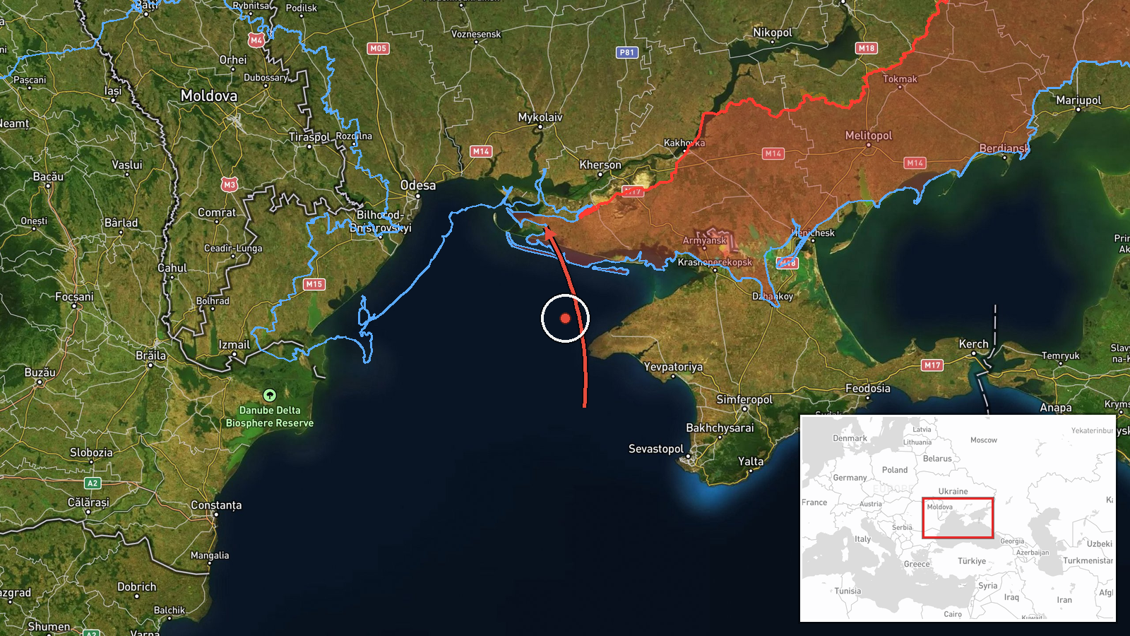
Ukraine's Air Force, posting on its official Telegram channel, reported at 07:29 UTC on 17 October 2026 one Russian Shahed-type drone moving from the Black Sea toward southern Mykolaiv Oblast. The original Ukrainian wording describes it as an 'ударний БпЛА' (strike unmanned aerial vehicle) arriving 'з акваторії Чорного моря' (from the Black Sea waters) and heading to the south of the oblast. The report names no settlement, impact point, damage, or casualties. The word 'toward' indicates direction of travel rather than a confirmed target, so this is best read as an air-monitoring alert rather than a report of an strike impact.
Context and assessment
The event sits within a cluster of activity along Ukraine's southern coast over roughly 24 hours. On 16 October at 09:50 UTC, a jet-powered Geran-3 drone was reported heading from the Black Sea toward Ochakiv, a port town on the Black Sea coast. Earlier that day, two or more Geran-3 drones were reported passing through Mykolaiv Oblast heading north, and another Shahed-type drone was tracked from Kherson Oblast into Mykolaiv Oblast. On 17 October, a Shahed-type drone was reported crossing Kherson Oblast toward the northwest, and a guided glide bomb was reported heading toward Kherson city shortly after 01:43 UTC. The repeated routing along the coast and through the Mykolaiv and Kherson axis suggests a sustained pattern of long-range drone traffic. Operationally, such transits may reflect attempts to reach inland infrastructure or ports, saturation or decoy tactics, or reconnaissance. The data alone does not establish which of these applies to this drone.
Sources and confidence
All information comes from one channel, the Telegram account of the Ukrainian Air Force, which is the official national air-monitoring source and is typically the first public alert for drone activity. The dataset records no independent cross-confirmation, and the confidence score of 8.0 reflects the authority of the source and the specificity of the timestamp, but not any corroboration. Confidence would rise with reports from regional military administrations, local officials, or impact confirmations, or with consistent entries across other monitoring channels. It would fall if the alert were later revised, withdrawn, or found to refer to a different aircraft.
Location
The location is region-level only. No settlement, facility, or grid reference is given, so the coordinates (46.42495, 32.0) are an approximate centroid for southern Mykolaiv Oblast and carry low location confidence. The area is largely flat steppe bordering the Black Sea, with the Bug estuary and coastal lagoons to the west and south. The Ochakiv and Kinburn Spit areas lie within or near the wider zone, which is why the coastal approach is relevant.
Related events nearby
- Ukrainian air monitoring: 1 Russian jet-powered Shahed (Geran-3) drone from Black Sea toward Ochakiv.2026-10-16 09:50 UTC · Drone Transit · Ochakiv, Ukraine
- Ukrainian air monitoring: 1 Russian Shahed-type drone passing Kherson Oblast, heading northwest.2026-10-17 06:44 UTC · Drone Transit · Kherson Oblast, Ukraine
- Ukrainian air monitoring: 1 Russian guided glide bomb (KAB) heading toward Kherson.2026-10-17 01:43 UTC · Airstrike · Kherson, Ukraine
- Ukrainian air monitoring: 1 Russian jet-powered Shahed (Geran-3) drone passing Mykolaiv Oblast, heading northw2026-10-17 07:39 UTC · Drone Transit · Mykolaiv Oblast, Ukraine
- Ukrainian air monitoring: 1 Russian Shahed-type drone from Kherson Oblast toward Mykolaiv Oblast.2026-10-16 14:34 UTC · Drone Transit · Mykolaiv Oblast, Ukraine
▶ View this event on the live map

Intel Mapper aggregates open-source reports from monitored Telegram and X channels, geolocates them, cross-checks duplicates across sources and assigns a confidence score. Entries are updated as new confirmations arrive. Read how we verify events.