Single jet-powered Geran-3 drone reported moving from Black Sea toward Ochakiv, Mykolaiv Oblast
What happened
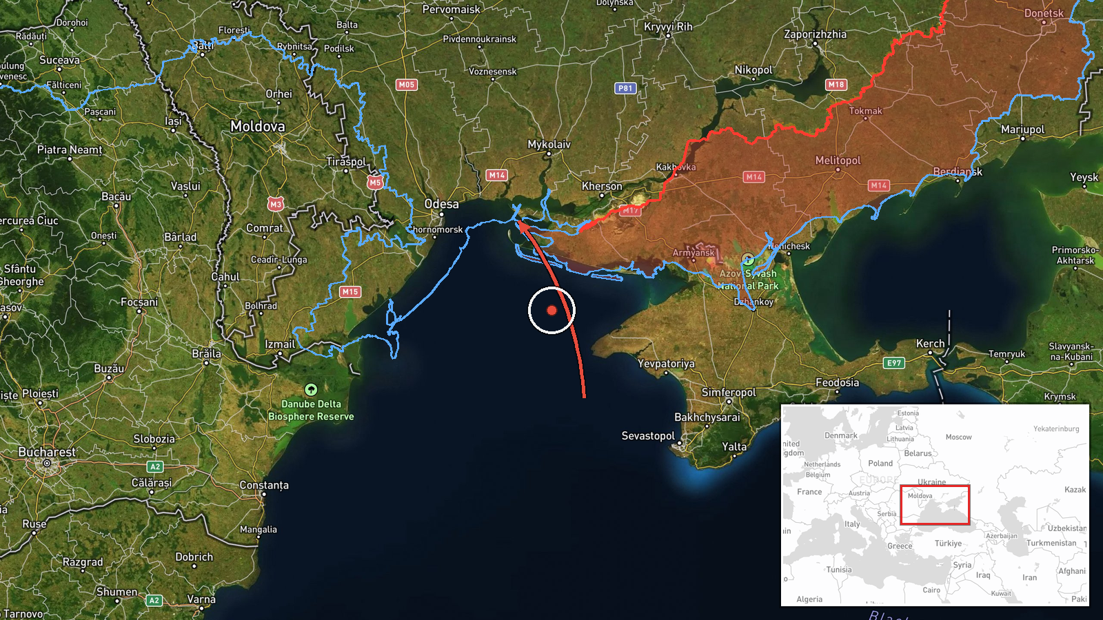
Ukrainian air monitoring reported on 16 October 2026, at about 09:50 UTC, that one Russian jet-powered Shahed (Geran-3) drone was heading from the Black Sea toward Ochakiv, a settlement in Mykolaiv Oblast in southern Ukraine. The report was posted in Ukrainian on a Telegram channel linked to the Ukrainian Air Force monitoring community, with the headline describing a jet drone flying toward Ochakiv from the water area of the Black Sea. The wording indicates a transit alert rather than a confirmed impact, and the report does not describe any strike, damage, or casualties at the time of posting. The event is recorded from a single source.
Context and assessment
Ochakiv sits on the Kinburn Spit approaches near the Dnipro-Bug estuary, a position that makes it a recurring point on the approach corridor for drones launched over the northwestern Black Sea. The related events show a sustained pattern over the previous day and a half: a drone reported from the Black Sea toward Pivdenne on 15 October, another from Odesa Oblast toward the same settlement later that day, and several groups of Geran-3 drones moving through southern and western Mykolaiv Oblast on 16 October, some heading north. Taken together, this suggests a steady stream of single and small-group transits along a coastal corridor rather than a single isolated launch. Operationally, the pattern may indicate routing toward inland targets, reconnaissance, or saturation of air defence coverage, though the data alone cannot confirm which. Jet-powered Geran-3 variants are generally associated with higher speed than the earlier piston-engine models, which would shorten warning times for local residents.
Sources and confidence
The event rests on one Telegram channel, @kpszsu, which is tied to Ukrainian air monitoring reporting. No second independent channel is listed in the data, so cross-confirmation is absent. The confidence score of 8.0 reflects a clear, specific report with a named drone type, direction, and destination, plus consistency with several related transit alerts that day. It is held below the maximum because the report is single-source and describes a transit, not a verified track or outcome. Confidence would rise with corroboration from additional monitoring channels or official regional air alerts, and would fall if later reporting contradicted the drone type or heading.
Location
The location is recorded at settlement precision, placing the point over Ochakiv itself, with high location confidence. The coordinates are approximately 46.61 N, 31.55 E. Ochakiv lies on the Black Sea coast of Mykolaiv Oblast, near the mouth of the Southern Bug and Dnipro estuary system. Nearby features include the Kinburn Spit, the Dnipro-Bug estuary waters, and the Tendra Bay area to the southwest. The flat, low-lying coastal terrain offers little natural cover from low-altitude drones.
Related events nearby
- Ukrainian air monitoring: 1 Russian jet-powered Shahed (Geran-3) drone from Odesa Oblast toward Pivdenne.2026-10-15 13:32 UTC · Drone Transit · Pivdenne, Ukraine
- Ukrainian air monitoring: 2+ Russian jet-powered Shahed (Geran-3) drones from Black Sea toward southern Mykola2026-10-16 01:07 UTC · Drone Transit · southern Mykolaiv Oblast, Ukraine
- Ukrainian air monitoring: 1 Russian jet-powered Shahed (Geran-3) drone passing western Mykolaiv Oblast, headin2026-10-16 04:01 UTC · Drone Transit · western Mykolaiv Oblast, Ukraine
- Ukrainian air monitoring: 2+ Russian jet-powered Shahed (Geran-3) drones passing Mykolaiv Oblast, heading nort2026-10-16 09:03 UTC · Drone Transit · Mykolaiv Oblast, Ukraine
- Ukrainian air monitoring: 1 Russian Shahed-type drone from south of Kropyvnytskyi toward Mykolaiv Oblast.2026-10-16 01:04 UTC · Drone Transit · Mykolaiv Oblast, Ukraine
▶ View this event on the live map

Intel Mapper aggregates open-source reports from monitored Telegram and X channels, geolocates them, cross-checks duplicates across sources and assigns a confidence score. Entries are updated as new confirmations arrive. Read how we verify events.