Ukrainian air monitors report jet-powered Shahed drone passing Horodnytsia toward Rivne Oblast
What happened
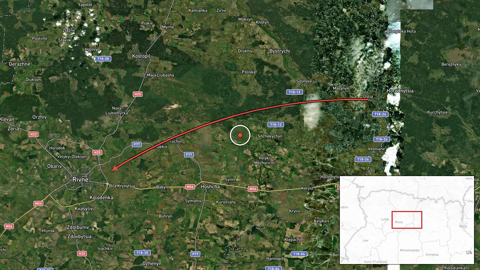
At 08:14 UTC on 17 October 2026, the Telegram channel @kpszsu reported one Russian jet-powered Shahed-type drone, identified as a Geran-3, passing near Horodnytsia and heading toward Rivne Oblast in western Ukraine. The original Ukrainian wording, 'Реактивний БпЛА повз Городницю на Рівненщину,' describes a jet-powered unmanned aerial vehicle flying past Horodnytsia on its way to the Rivne region. The report is an air-monitoring notice. It does not describe an impact, a casualty, or damage. It gives no altitude, speed, or confirmed point of impact. The event is logged as a drone transit, meaning the aircraft was tracked moving through airspace rather than striking a target.
Context and assessment
Rivne Oblast sits in northwestern Ukraine, close to the Belarusian border and well west of the front line, so drones crossing it usually reflect long-range routing rather than close combat. The related events show a sustained pattern. Between 14:40 and 16:17 UTC on 16 October, separate reports described jet-powered Geran-3 drones moving through Khmelnytskyi and Zhytomyr oblasts toward Rivne, and a further unspecified Shahed-type drone was logged heading toward Rivne Oblast at 15:05. Early on 17 October, another Shahed-type drone was logged heading west through the oblast at 06:29, followed by the jet-powered drone toward Rivne at 08:18. Taken together, these entries suggest a series of aircraft following similar corridors across central and western Ukraine over roughly eighteen hours. Operationally, a repeated westward or northwestward track can indicate a route aimed at infrastructure or a target farther west, but single transit reports cannot confirm intent. Monitoring entries like these are most useful for tracking the flight path and tempo of the campaign, not for judging where any drone may finally go.
Sources and confidence
The event rests on one Telegram channel, @kpszsu, which is generally understood to be an official Ukrainian air-monitoring feed. No second outlet or independent tracking source is listed in the data. Related entries share the same reporting format, which supports consistency across the series but not independent verification of this specific track. The confidence score of 8.0 reflects a credible official-style channel, a clear and specific description, and a timestamp. It is held below the top range because there is only one source, no imagery or radar confirmation is attached, and the exact path is not documented. Confirmation from a second monitoring feed, a regional military administration statement, or a documented impact would raise confidence. A correction notice or evidence that the drone was a different type would lower it.
Location
The coordinates, 50.62 N and 26.25 E, are region-level, which means they were set to a point representing Rivne Oblast rather than to the place the drone was observed. The place name Horodnytsia comes from the Ukrainian source text, so the precise settlement was not confirmed by a geographic data point. The area is largely flat to gently rolling terrain of farmland, forest belts, and river valleys in western Ukraine. Notable nearby features include the Horyn and Stub river systems and the Polissia forest zone, which can affect low-altitude radar coverage. The text should therefore be read as a broad corridor reference rather than a fixed observation point.
Related events nearby
- Ukrainian air monitoring: 1 Russian jet-powered Shahed (Geran-3) drone heading toward Rivne.2026-10-17 08:18 UTC · Drone Transit · Rivne, Ukraine
- Ukrainian air monitoring: 1 Russian Shahed-type drone passing Rivne Oblast, heading west.2026-10-17 06:29 UTC · Drone Transit · Rivne Oblast, Ukraine
- Ukrainian air monitoring: 1 Russian jet-powered Shahed (Geran-3) drone from Zhytomyr Oblast toward Rivne.2026-10-16 16:17 UTC · Drone Transit · Rivne, Ukraine
- Ukrainian air monitoring: 1 Russian Shahed-type drone heading toward Rivne Oblast.2026-10-16 15:05 UTC · Drone Transit · Rivne Oblast, Ukraine
- Ukrainian air monitoring: 1 Russian jet-powered Shahed (Geran-3) drone from Khmelnytskyi Oblast toward Rivne O2026-10-16 14:40 UTC · Drone Transit · Rivne Oblast, Ukraine
▶ View this event on the live map

Intel Mapper aggregates open-source reports from monitored Telegram and X channels, geolocates them, cross-checks duplicates across sources and assigns a confidence score. Entries are updated as new confirmations arrive. Read how we verify events.