Single Shahed-type drone reported moving from northern Zhytomyr toward northern Rivne Oblast
What happened
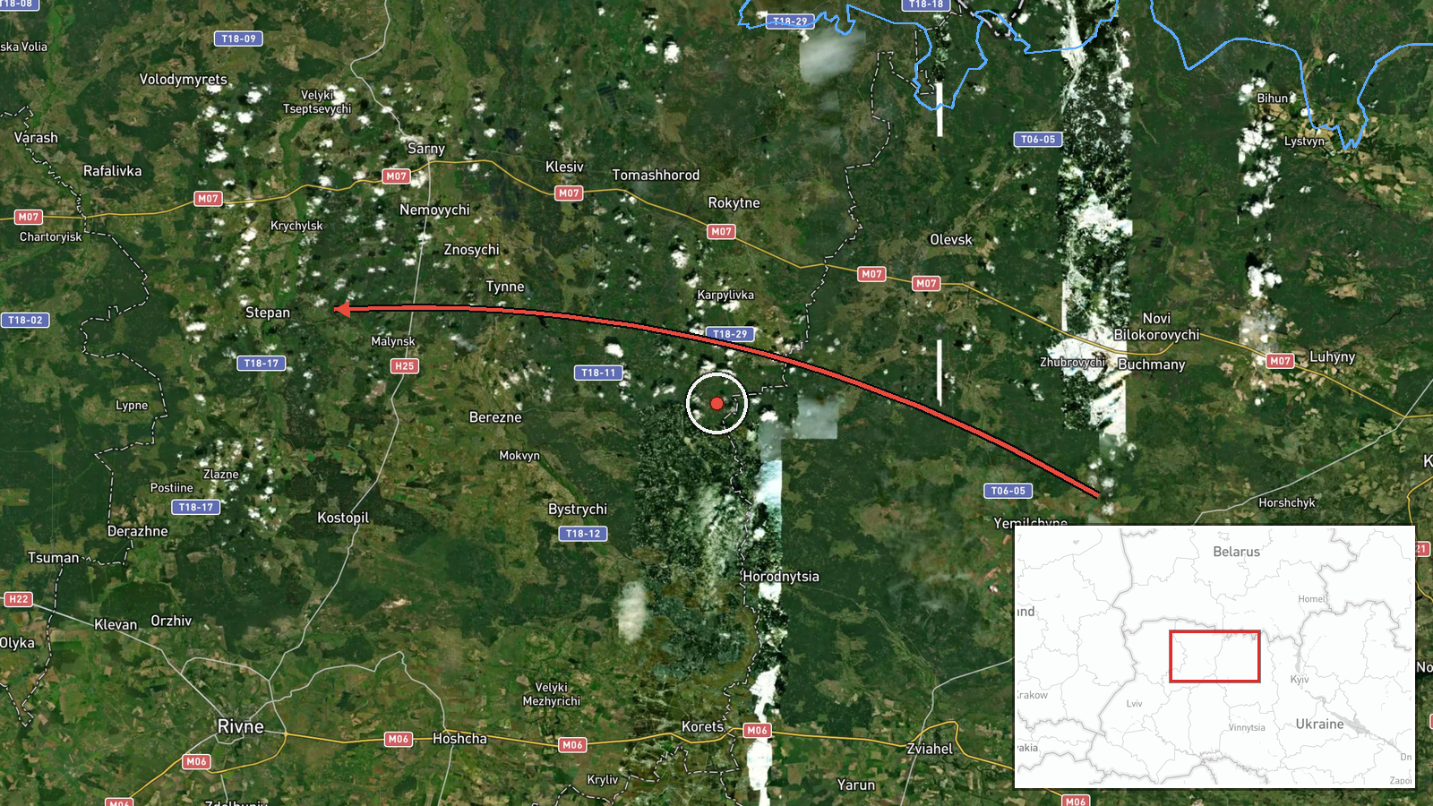
Ukrainian air monitoring reported one Russian Shahed-type drone transiting from northern Zhytomyr Oblast toward northern Rivne Oblast on 17 October 2026, at about 08:32 UTC. The only report comes from the Telegram channel @kpszsu, which posted the update in Ukrainian with a short arrow-style description: a strike drone moving from the north of Zhytomyr region to the north of Rivne region. The post names no impact, target, or casualties, and it does not state a specific settlement as the drone's destination. The wording describes a flight path rather than a confirmed strike, so the event should be read as a tracked airborne movement. Reports of this kind are typically issued as air-alert updates while a drone is still in flight.
Context and assessment
The location sits within a corridor of repeated drone activity over northwestern Ukraine. In the preceding hours, the monitoring feed recorded a series of similar single-drone transits: one jet-powered Shahed, also known as Geran-3, heading toward Sarny on 16 October at 17:26 UTC; a Shahed-type drone heading toward Kostopil at 21:31 UTC; a group of drones reported near Dubrovytsya and Korosten in the early hours of 17 October; and two further jet-powered drones tracked toward Rivne and Rivne Oblast around 08:14 and 08:18 UTC. Taken together, the sequence suggests a steady pattern of long-range drones crossing the region on a broadly northwestward or westward heading, rather than isolated incidents. Such routing is often associated with flights toward distant targets, where drones pass over rural areas, and occasionally with efforts to saturate air defenses. The pattern does not, by itself, identify the intended target. Operationally, the sequence indicates ongoing aerial surveillance and frequent launches in this sector.
Sources and confidence
The event rests on one Telegram channel, @kpszsu, which is the channel the event record lists for this report. The related events in the same sequence come from the same feed type, so they share the same single-source limitation and have not been independently confirmed by other outlets in the data provided. The confidence score of 8.0 reflects a credible official-style air monitoring source with a clear, specific description, but it is capped by the absence of cross-confirmation and by the ambiguity of a transit report. Confidence would rise with corroboration from a second monitoring or government channel, or from wreckage or impact reports. It would fall if later updates revised the drone count, the route, or the report's timing.
Location
The location is recorded at region level for northern Rivne Oblast, with a low location confidence and a coordinate roughly 51.17 N, 26.25 E that represents a general point rather than a specific settlement or facility. The report describes a transit path, so no fixed site was identified. The area lies in the Polissia lowlands of northwestern Ukraine, a region of flat terrain, forests, marshland, and river valleys. Nearby reference points named in the related events include Sarny, Kostopil, and Rivne, which help place the flight path within the broader oblast.
Related events nearby
- Ukrainian air monitoring: 1 Russian jet-powered Shahed (Geran-3) drone heading toward Sarny.2026-10-16 17:26 UTC · Drone Transit · Sarny, Ukraine
- Ukrainian air monitoring: 1 Russian Shahed-type drone heading toward Kostopil.2026-10-16 21:31 UTC · Drone Transit · Kostopil, Ukraine
- Ukrainian air monitoring: 1 Russian Shahed-type drone heading toward Dubrovytsya; 1 Russian Shahed-type drone 2026-10-17 05:53 UTC · Drone Transit · Dubrovytsya, Ukraine
- Ukrainian air monitoring: 1 Russian jet-powered Shahed (Geran-3) drone heading toward Rivne.2026-10-17 08:18 UTC · Drone Transit · Rivne, Ukraine
- Ukrainian air monitoring: 1 Russian jet-powered Shahed (Geran-3) drone passing Horodnytsia, heading toward Riv2026-10-17 08:14 UTC · Drone Transit · Rivne Oblast, Ukraine
▶ View this event on the live map

Intel Mapper aggregates open-source reports from monitored Telegram and X channels, geolocates them, cross-checks duplicates across sources and assigns a confidence score. Entries are updated as new confirmations arrive. Read how we verify events.