Russian Shahed-type drone reported heading toward Khorol, Poltava Oblast
What happened
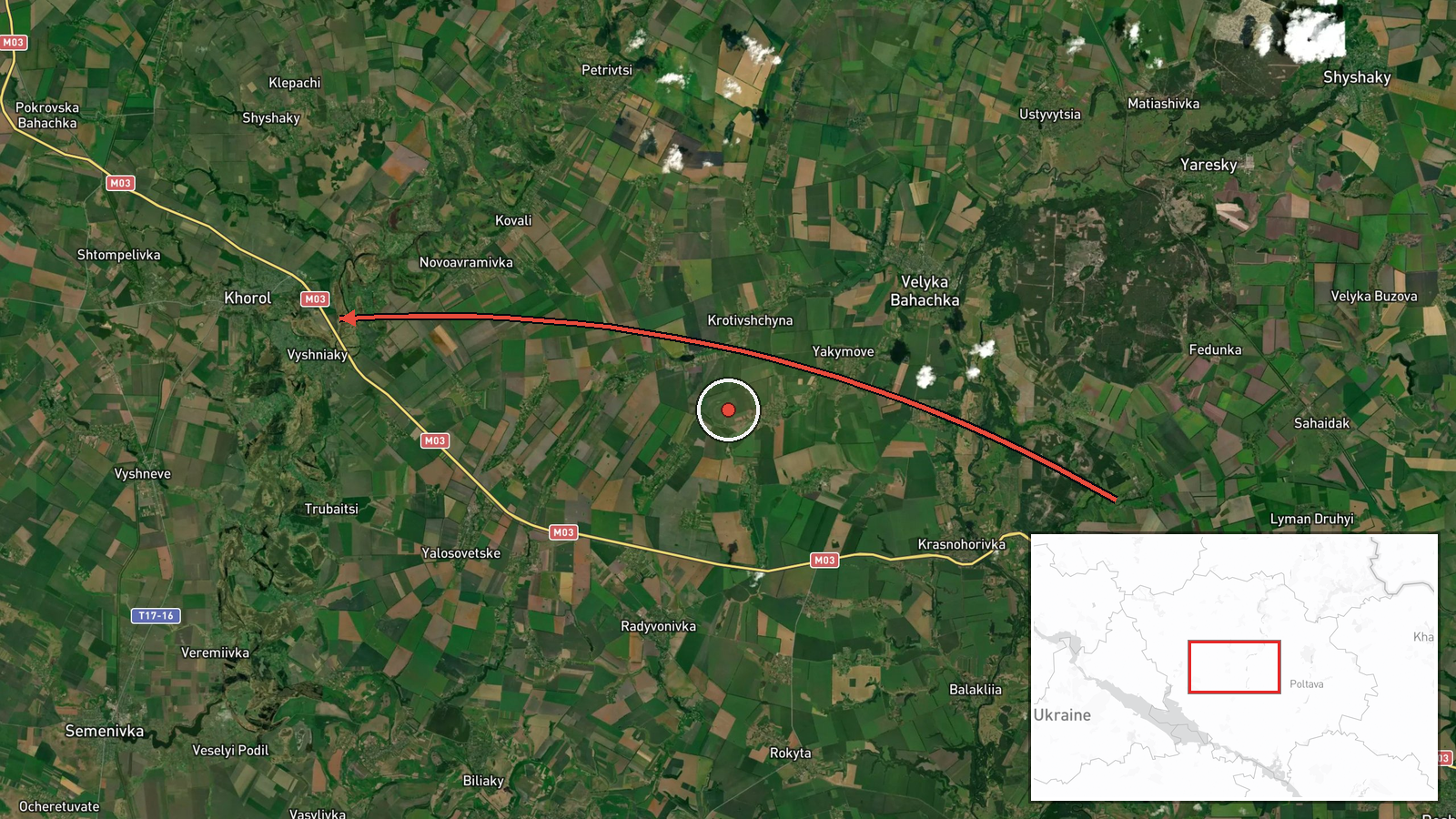
On 17 October 2026 at 11:31 UTC, a single Telegram channel, @kpszsu, reported one Russian Shahed-type drone heading toward Khorol in Poltava Oblast. The original Ukrainian text describes a UAV approaching Khorol from the northeast. The report is a standard air-monitoring alert: it records a drone track and the settlement it was heading toward, not a confirmed impact, strike damage, or casualties. The source does not name a launch point, so the origin field is empty. It also gives no altitude, speed, or interception outcome. Because the event is classed as Drone Transit, it should be read as a flight track in the monitoring feed rather than a documented attack on the town.
Context and assessment
Khorol sits in the central part of Poltava Oblast, within a band of towns and military-related sites that Ukrainian air monitoring has tracked through the same morning. The related reports form a visible pattern. Earlier on 16 October, single drones were logged heading toward Kremenchuk and Lubny, and a jet-powered Shahed variant was reported near Lubny. Overnight into 17 October, another jet-powered drone was reported heading toward Hlobyne. Later that morning, a drone was logged toward Velyki Sorochyntsi and Myrhorod, and two or more drones were reported passing Kozelshchyna on a northwesterly heading. Taken together, these reports suggest drones moving through a corridor across the oblast over a short period. Operationally, such tracks may indicate routing toward distant objectives, a deliberate spread of targets that stretches air defence, or drones being redirected after launch. The reports alone cannot show which of these applies. Khorol is named here as a heading, not as a confirmed target, so any strike or damage assessment would need separate reporting.
Sources and confidence
Only one channel, Telegram @kpszsu, is recorded for this event, so there is no second outlet or independent tracking source to cross-confirm it. The confidence score of 8.0 reflects a specific original text, a plausible track consistent with nearby reports, and a high location confidence. It is kept below the top of the scale because the report is single-source and lacks a launch point or outcome. Confidence would rise if a second monitoring channel, a regional military administration, or track data corroborated the heading. It would fall if later updates revised the destination, reported the drone diverted or downed, or showed no matching track.
Location
Khorol is a small town in Poltava Oblast in central Ukraine. Its marker is placed at settlement level with high location confidence, so it reflects the town as a whole rather than a specific facility. The surrounding terrain is mostly open agricultural land typical of the region, with river valleys and rural roads. Other places in the same air picture, including Lubny, Hlobyne, Myrhorod and Kozelshchyna, lie within a corridor across the oblast, which helps place the track geographically.
Related events nearby
- Ukrainian air monitoring: 1 Russian jet-powered Shahed (Geran-3) drone heading toward Lubny.2026-10-16 18:34 UTC · Drone Transit · Lubny, Ukraine
- Ukrainian air monitoring: 1 Russian jet-powered Shahed (Geran-3) drone heading toward Hlobyne.2026-10-17 00:06 UTC · Drone Transit · Hlobyne, Ukraine
- Ukrainian air monitoring reports a Russian Shahed-type drone heading toward Velyki Sorochyntsi and Myrhorod in2026-10-17 11:24 UTC · Drone Transit · Velyki Sorochyntsi, Ukraine
- Ukrainian air monitoring: 2+ Russian jet-powered Shahed (Geran-3) drones passing Kozelshchyna, heading northwe2026-10-17 11:55 UTC · Drone Transit · Kozelshchyna, Ukraine
- Ukrainian air monitoring: 1 Russian Shahed-type drone heading toward Kremenchuk.2026-10-16 18:29 UTC · Drone Transit · Kremenchuk, Ukraine
▶ View this event on the live map

Intel Mapper aggregates open-source reports from monitored Telegram and X channels, geolocates them, cross-checks duplicates across sources and assigns a confidence score. Entries are updated as new confirmations arrive. Read how we verify events.