Reactive Shahed-type drone reported moving from Khmelnytskyi into Ternopil Oblast
What happened
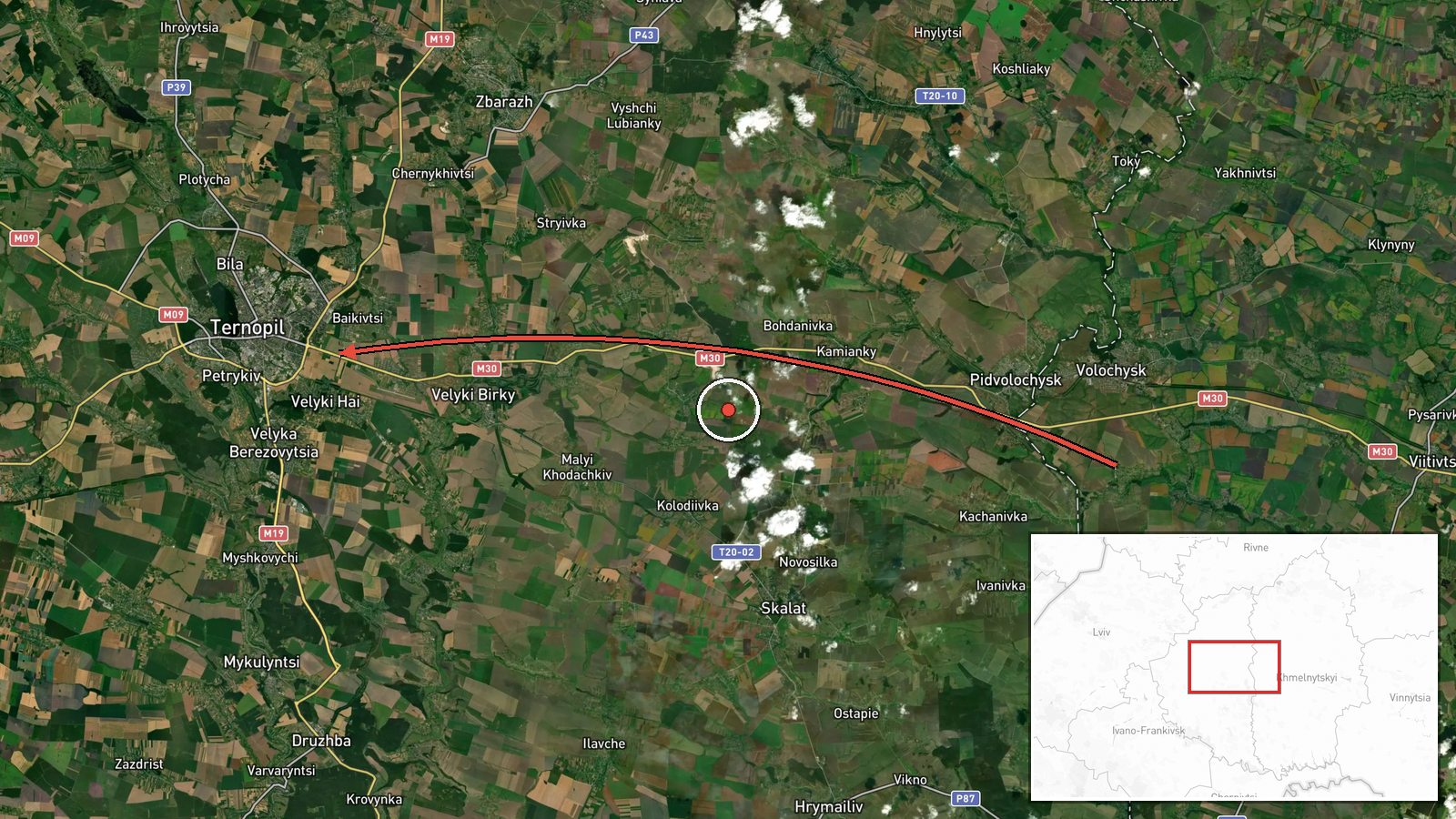
Ukrainian air monitoring reported a single jet-powered Russian Shahed-type drone, identified in the source as a Geran-3, passing near the village of Viytivtsi in Khmelnytskyi Oblast and heading toward Ternopil Oblast in western Ukraine. The report was posted at 15:26 UTC on 17 October 2026. The original Ukrainian wording describes a 'reactive UAV' (Реактивний БпЛА) moving from Khmelnytskyi toward Ternopil, with an arrow indicating direction of travel. The report describes a transit only. It does not mention impacts, damage, casualties, or the drone's final destination, and no further details were given in the source text.
Context and assessment
This event is one of several single-drone transit reports across Ternopil Oblast within roughly a day. Earlier reports on 16 October placed a drone passing Chortkiv heading west, and on 17 October separate reports described drones from Khmelnytskyi toward Krasyliv at 06:23 UTC, from Ternopil toward Zbarazh at 06:46, and passing Ternopil heading west at 06:59. A further report placed a drone heading toward Krasyliv at 14:43, shortly before this one. The repeated pattern of individual drones entering from Khmelnytskyi and crossing Ternopil suggests a sustained flight path through the region rather than a single isolated sortie. Operationally, the reports are consistent with long-range drones routed through western Ukraine, but transit sightings alone do not establish a target. The jet-powered variant is generally associated with higher speed, which could affect how far in advance warnings arrive. Any link to a specific facility or city would require further reporting.
Sources and confidence
The report comes from a single Telegram channel, @kpszsu, which is widely associated with Ukrainian air monitoring, and it was not independently reproduced in the related events supplied. The related events are consistent in type and region, which supports the broader pattern but does not confirm this specific sighting. The confidence score of 8.0 reflects the channel's established role in air alerts and the consistency of the surrounding reports, offset by the single-source basis and the lack of a precise position. Confidence would rise with corroboration from additional Ukrainian official channels or regional military administrations, or with a timestamped track. It would fall if later reporting revised the drone's type, direction, or route.
Location
The location is recorded at region level as Ternopil Oblast, with coordinates of 49.55 N, 25.59 E, and location confidence is marked low. The coordinates do not mark the drone's actual position at the time of the report. The reported route runs from Viytivtsi in Khmelnytskyi Oblast into Ternopil Oblast, which lies in western Ukraine. The exact track of the drone within the oblast is not specified in the source.
Related events nearby
- Ukrainian air monitoring: 1 Russian Shahed-type drone passing Ternopil Oblast, heading west.2026-10-17 06:59 UTC · Drone Transit · Ternopil Oblast, Ukraine
- Ukrainian air monitoring: 1 Russian Shahed-type drone from Ternopil Oblast toward Zbarazh.2026-10-17 06:46 UTC · Drone Transit · Zbarazh, Ukraine
- Ukrainian air monitoring: 1 Russian Shahed-type drone passing Chortkiv, heading west.2026-10-16 21:03 UTC · Drone Transit · Chortkiv, Ukraine
- Ukrainian air monitoring: 1 Russian Shahed-type drone heading toward Krasyliv.2026-10-17 14:43 UTC · Drone Transit · Krasyliv, Ukraine
- Ukrainian air monitoring: 1 Russian Shahed-type drone from Khmelnytskyi Oblast toward Krasyliv.2026-10-17 06:23 UTC · Drone Transit · Krasyliv, Ukraine
▶ View this event on the live map

Intel Mapper aggregates open-source reports from monitored Telegram and X channels, geolocates them, cross-checks duplicates across sources and assigns a confidence score. Entries are updated as new confirmations arrive. Read how we verify events.