Ukrainian monitoring reports one Shahed-type drone heading toward Zbarazh, Ternopil Oblast
What happened
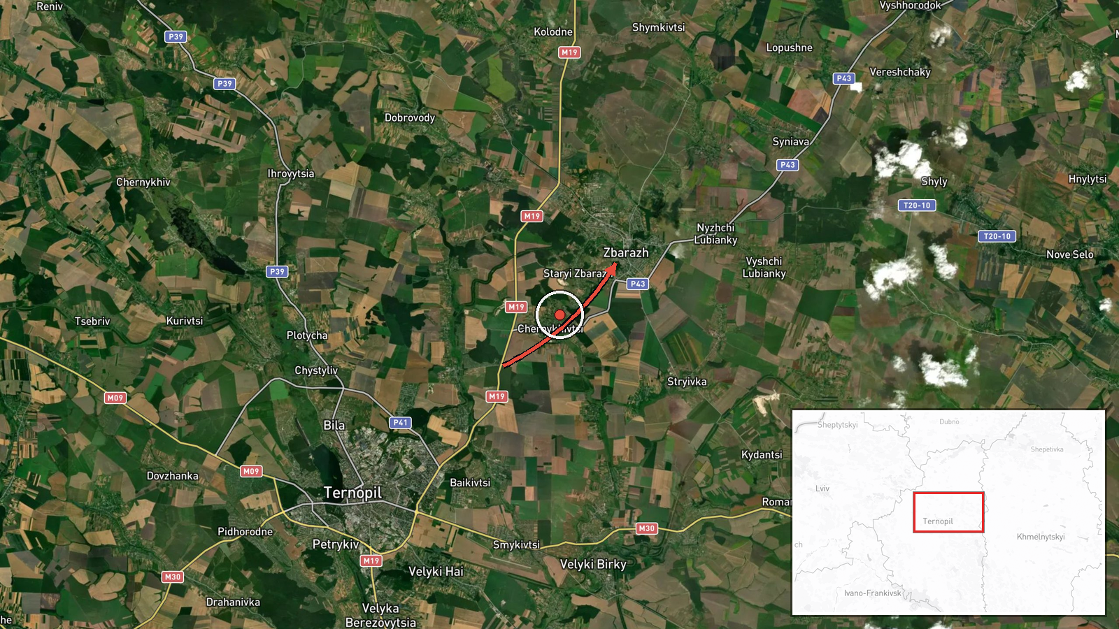
Ukrainian air monitoring, relayed through the Telegram channel @kpszsu, reported at 06:46 UTC on 17 October 2026 a single Russian Shahed-type drone moving toward Zbarazh in Ternopil Oblast, western Ukraine. The original post, written in Ukrainian as 'БпЛА у напрямку Збаража на Тернопільщині', is brief. It names the drone's direction of travel toward the town and says nothing about impact, damage, or casualties. The summary field describes the drone as coming from Ternopil Oblast, but the original wording does not fix an origin point, so that detail should be read cautiously. The entry is a monitoring notice of an airborne track, not a confirmation of a strike.
Context and assessment
Zbarazh sits in the lowlands of Ternopil Oblast, a region that Russian long-range drones have crossed repeatedly on routes toward western Ukraine. The related events show a sequence of single-drone reports on 16 and 17 October. A track was logged near Tyvriv in Khmelnytskyi Oblast at 11:46 UTC on 16 October, followed by a report heading toward Khmelnytskyi at 17:53. A drone was then noted passing Chortkiv, heading west, at 21:03, and another was reported from Khmelnytskyi Oblast toward Krasyliv at 06:23 on 17 October. A drone passing Ternopil Oblast heading west followed at 06:59. Taken together, the reports suggest a drone or drones moving along a broadly westward corridor through central and western Ukraine. Operationally, a pattern of single tracks like this may reflect reconnaissance, route testing, decoy use, or spread-out flights designed to stretch air defence coverage. Because each report covers one aircraft and none records impact, the reports alone do not show intent.
Sources and confidence
The report rests on a single Telegram channel, @kpszsu, which is widely associated with the Ukrainian Air Force. No second outlet in the dataset independently confirms this specific track. The confidence score of 8.0 reflects a credible, official-style source with high location precision, offset by the absence of cross-confirmation and by the thin wording of the post. Confidence would rise with independent corroboration, such as a regional military administration statement, a second channel reporting the same track, or a documented impact. It would fall if the channel corrected or withdrew the notice, or if later tracking placed the drone elsewhere.
Location
The location is recorded at settlement precision, meaning the coordinates approximate the centre of Zbarazh rather than a specific site. The town's location is consistent with the wording 'toward Zbarazh', but the drone's actual track is not known at that level of detail. Zbarazh lies in Ternopil Oblast in western Ukraine, in gently rolling farmland and lowland terrain. Nearby features are mainly agricultural land, small rivers, and the road and rail links that connect Ternopil to the north and east. No specific military or industrial facility is named in the report.
Related events nearby
- Ukrainian air monitoring: 1 Russian Shahed-type drone passing Ternopil Oblast, heading west.2026-10-17 06:59 UTC · Drone Transit · Ternopil Oblast, Ukraine
- Ukrainian air monitoring: 1 Russian Shahed-type drone passing Chortkiv, heading west.2026-10-16 21:03 UTC · Drone Transit · Chortkiv, Ukraine
- Ukrainian air monitoring: 1 Russian Shahed-type drone from Khmelnytskyi Oblast toward Krasyliv.2026-10-17 06:23 UTC · Drone Transit · Krasyliv, Ukraine
- Ukrainian air monitoring: 1 Russian Shahed-type drone heading toward Khmelnytskyi.2026-10-16 17:53 UTC · Drone Transit · Khmelnytskyi, Ukraine
- Ukrainian air monitoring: 1 Russian Shahed-type drone passing Tyvriv, heading toward Khmelnytskyi Oblast.2026-10-16 11:46 UTC · Drone Transit · Khmelnytskyi Oblast, Ukraine
▶ View this event on the live map

Intel Mapper aggregates open-source reports from monitored Telegram and X channels, geolocates them, cross-checks duplicates across sources and assigns a confidence score. Entries are updated as new confirmations arrive. Read how we verify events.