Single Shahed-type drone reported over Vinnytsia region, heading west toward Khmelnytskyi Oblast
What happened
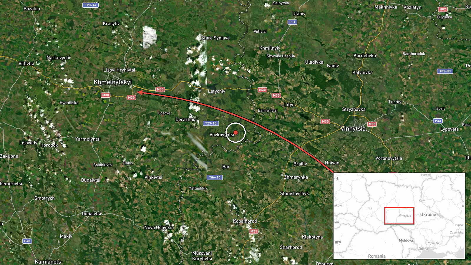
Ukrainian air monitoring reported one Russian Shahed-type drone passing the area of Baru and Tyvriv in Vinnytsia Oblast and continuing on a westward course toward Khmelnytskyi Oblast. The report was posted on the Telegram channel @kpszsu on 16 October 2026 at 11:46 UTC. The original Ukrainian wording describes a UAV in the Baru and Tyvriv area moving west toward Khmelnytskyi, while the English summary specifies a single drone and a Shahed-type classification. The report gives no information on impact, damage, casualties, or whether the drone was intercepted. It is one of several drone transits logged toward Khmelnytskyi over the preceding day and a half.
Context and assessment
Khmelnytskyi Oblast lies in western Ukraine, a region that has repeatedly appeared on air-alert maps as drones move from the north and east toward areas further west. The five related entries from 15 and 16 October show a sustained pattern: single and multiple drones, described as jet-powered Shahed or Geran-3 variants, heading toward Khmelnytskyi and Krasyliv. One batch of at least two drones was reported moving from western Rivne Oblast toward Khmelnytskyi Oblast early on 16 October. The same general corridor is therefore being used repeatedly within a short window. That may suggest routing toward targets beyond Khmelnytskyi, or deliberate probing of air defence coverage in the west. Transit reports of this kind do not by themselves identify an intended target, and none of the supplied sources names one. A plausible hedged reading is that repeated transits along the same axis reflect routing choices, decoy use, or movement toward areas farther west. Analysts would look for follow-up reports of impacts or interceptions before drawing firmer conclusions about purpose.
Sources and confidence
The report rests on a single Telegram channel, @kpszsu, with no independent cross-confirmation in the supplied data, and the event is recorded with one source and a confidence score of 8.0. The score is relatively high for a single-source report because the channel is an official Ukrainian Air Force feed routinely used for air alerts. It is not higher because no second outlet, radar-based tracking record, or impact report corroborates the sighting. Confidence would rise with matching reports from regional military administrations or follow-up interception reports. It would fall if later reporting contradicts the route, the drone count, or the classification.
Location
The location is recorded at region level as Khmelnytskyi Oblast, with coordinates of 49.42 N and 26.98 E, and location confidence is marked low. These coordinates are a regional reference point rather than a settlement, so they should not be read as the drone's exact position. The sighting itself was described near Baru and Tyvriv in Vinnytsia Oblast, with the drone heading west toward Khmelnytskyi Oblast. The area is largely agricultural terrain with river valleys, scattered forest patches, and a dense network of small rural settlements.
Related events nearby
- Ukrainian air monitoring: 2+ Russian jet-powered Shahed (Geran-3) drones heading toward Khmelnytskyi; 1 Russia2026-10-16 04:24 UTC · Drone Transit · Khmelnytskyi, Ukraine
- Ukrainian air monitoring: 2+ Russian jet-powered Shahed (Geran-3) drones from western Rivne Oblast toward Khme2026-10-16 03:05 UTC · Drone Transit · Khmelnytskyi Oblast, Ukraine
- Ukrainian air monitoring: 1 Russian jet-powered Shahed (Geran-3) drone heading toward Khmelnytskyi.2026-10-15 16:04 UTC · Drone Transit · Khmelnytskyi, Ukraine
- Ukrainian air monitoring: 2+ Russian jet-powered Shahed (Geran-3) drones passing Khmelnytskyi, heading toward 2026-10-15 17:35 UTC · Drone Transit · Krasyliv, Ukraine
- Ukrainian air monitoring: 1 Russian Shahed-type drone heading toward Krasyliv.2026-10-15 16:59 UTC · Drone Transit · Krasyliv, Ukraine
▶ View this event on the live map

Intel Mapper aggregates open-source reports from monitored Telegram and X channels, geolocates them, cross-checks duplicates across sources and assigns a confidence score. Entries are updated as new confirmations arrive. Read how we verify events.