Shahed-type drone reported heading from Kyiv Oblast toward Korostyshiv, Zhytomyr Oblast
What happened
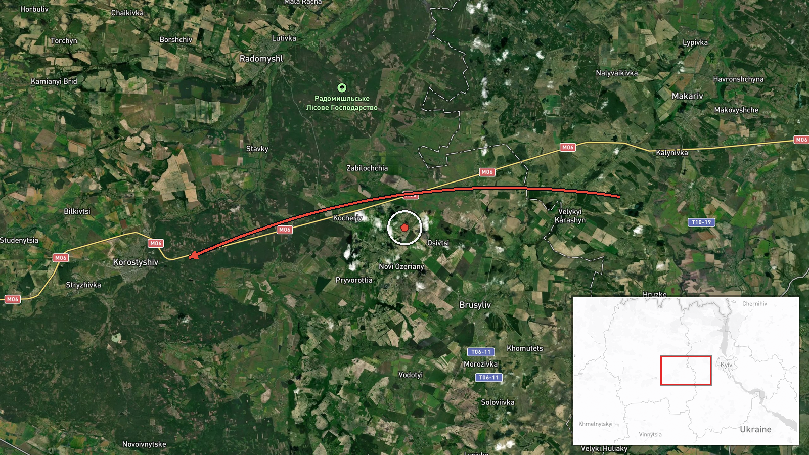
Ukraine's Air Force monitoring channel on Telegram (@kpszsu) reported on 18 October 2026, at 02:04 UTC, that one Shahed-type drone was moving from Kyiv Oblast toward the settlement of Korostyshiv in Zhytomyr Oblast. The original Ukrainian wording describes a UAV heading to Zhytomyr region in the direction of Korostyshiv from Kyiv region, which is the standard format of an air-alert transit notice. The post does not report impact, casualties, damage, or interception, and it does not identify the launch site or a final target. The event is recorded as a drone transit rather than a strike. Russia is listed as the actor, consistent with the drone type and the ongoing conflict, but attribution rests on the drone classification in a single channel's report.
Context and assessment
Korostyshiv sits on the main western corridor from the Kyiv region into Zhytomyr Oblast, so a drone logged here fits a pattern of long-range Shahed-type aircraft crossing northern and central Ukraine on routes toward the west. The related events show this clearly. On 17 October 2026, monitoring reports logged Shahed-type drones passing Zhytomyr Oblast heading west at 03:37 and 08:00 UTC, and a jet-powered Geran-3 variant heading toward Zhytomyr at 04:15 UTC. A further drone moved from Zhytomyr Oblast toward Malyn at 07:52 UTC. The Korostyshiv report therefore continues a sequence of repeated transits through the same oblast over roughly one day. Operationally, this pattern may suggest airborne routing through the region rather than a single targeted attack, although it may also reflect decoy or saturation tactics, or drones heading for targets further west. The Geran-3 mentions indicate that more than one airframe type is in use along these routes. The data does not confirm the destination of this particular aircraft, so any target assessment remains speculative.
Sources and confidence
The event rests on one channel, the Telegram account @kpszsu, which is the official air monitoring feed of Ukraine's Armed Forces and is generally used for real-time alerts. No independent outlet or second channel in the data confirms this specific track, so cross-confirmation is absent. The confidence score of 8.0 reflects a credible official source with a clear location and a specific drone type, offset by the single-source basis and the absence of corroboration or follow-up reporting. Confidence would rise if other monitoring channels, regional military administrations, or local reports confirmed the track or a subsequent impact. It would fall if the alert were revised, withdrawn, or found to refer to a different aircraft.
Location
The location is a settlement-level match to Korostyshiv, a town in Zhytomyr Oblast, using coordinates of roughly 50.32 N and 29.06 E, and the precision is marked as high. The coordinates were assigned from the named settlement in the report, not from a specific facility or impact point. Korostyshiv lies in northern Ukraine in a transitional zone of farmland, forest and river valleys between the Kyiv and Zhytomyr areas. Nearby Malyn, mentioned in the related events, lies to the north-east. The Zhytomyr city area is to the west.
Related events nearby
- Ukrainian air monitoring: 1 Russian jet-powered Shahed (Geran-3) drone passing Zon, heading toward Zhytomyr Ob2026-10-18 02:50 UTC · Drone Transit · Zhytomyr Oblast, Ukraine
- Ukrainian air monitoring: 1 Russian Shahed-type drone heading toward Zhytomyr.2026-10-18 02:04 UTC · Drone Transit · Zhytomyr, Ukraine
- Ukrainian air monitoring: 1 Russian Shahed-type drone passing Zhytomyr Oblast, heading west.2026-10-17 08:00 UTC · Drone Transit · Zhytomyr Oblast, Ukraine
- Ukrainian air monitoring: 1 Russian jet-powered Shahed (Geran-3) drone heading toward Zhytomyr.2026-10-17 04:15 UTC · Drone Transit · Zhytomyr, Ukraine
- Ukrainian air monitoring: 1 Russian Shahed-type drone passing Zhytomyr Oblast, heading west.2026-10-17 03:37 UTC · Drone Transit · Zhytomyr Oblast, Ukraine
▶ View this event on the live map

Intel Mapper aggregates open-source reports from monitored Telegram and X channels, geolocates them, cross-checks duplicates across sources and assigns a confidence score. Entries are updated as new confirmations arrive. Read how we verify events.