Jet-powered Russian Shahed (Geran-3) drone reported moving from Vinnytsia toward Khmelnytskyi
What happened
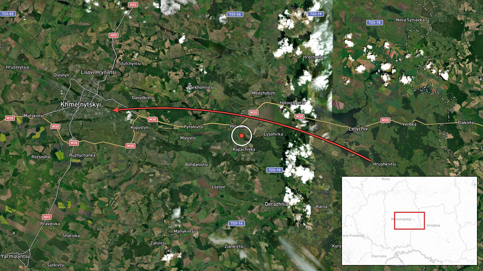
Ukrainian air monitoring, as relayed by the Telegram channel @kpszsu, reported on 18 October 2026 at 06:34 UTC a single Russian jet-powered Shahed-type drone, identified in the report as a Geran-3, moving from Vinnytsia Oblast toward Khmelnytskyi. The original Ukrainian-language message describes a jet-type unmanned aerial vehicle flying from the Vinnytsia region on a course toward Khmelnytskyi city. The map pins the event to Khmelnytskyi at settlement precision. The report names no impact, damage or casualties, and the source wording describes only the track of the object. Attribution to Russia rests on the monitoring message's identification of the drone type, which is widely associated with Russian long-range strike operations. Four nearby reports in the same feed, between 14:13 on 17 October and 06:57 on 18 October, describe further single drones over the oblast and at Krasyliv.
Context and assessment
Khmelnytskyi Oblast lies in western Ukraine, adjacent to Vinnytsia and Ternopil oblasts, and hosts military and logistics infrastructure, which is one reason the area appears often in air-alert reporting. Its position also places it on routes drones use when flying toward western targets, so tracks crossing it recur in monitoring feeds. The related events show a cluster on 17 and 18 October 2026: a Shahed-type drone over the oblast at 14:13 on 17 October, another passing Derazhnya at 14:25 heading toward Khmelnytskyi, then two Geran-3 reports over Krasyliv on the morning of 18 October, one at 06:44 heading north and one at 06:57. The sequence suggests one or more drones tracked across the region over roughly seventeen hours, with the Krasyliv reports possibly indicating a northward track rather than a single fixed target. Operationally, such transit reports may point to routing toward targets further west or north, or to decoy and saturation patterns, but the feed alone does not establish intent. Jet-powered variants are generally faster than the original piston-engined design, which can shorten warning times for air defence units.
Sources and confidence
The only channel in this record is the Telegram account @kpszsu, widely understood to be the Ukrainian Air Force's monitoring channel, which posts real-time air-alert and track messages. No independent outlet or second channel is listed, so cross-confirmation is absent. The confidence score of 8.0 out of 10 reflects a credible official-style source, a clearly stated track, and consistent related reports, offset by single-channel sourcing and the lack of any independent visual or impact record. Confidence would rise with corroboration from a second monitoring feed, regional military administration statements, or impact or wreckage reports. It would fall if later updates revised the track or the drone type.
Location
The pin sits on Khmelnytskyi, the regional capital of Khmelnytskyi Oblast, at settlement precision, and location confidence is rated high. The city is the named target in the message, so the coordinates reflect the stated heading rather than a confirmed drone position. Khmelnytskyi lies on the Southern Bug river in the Podillia upland, a region of rolling terrain, farmland and river valleys that shape low-altitude drone routing.
Related events nearby
- Ukrainian air monitoring: 1 Russian jet-powered Shahed (Geran-3) drone over Khmelnytskyi.2026-10-18 06:38 UTC · Drone Transit · Khmelnytskyi, Ukraine
- Ukrainian air monitoring: 1 Russian Shahed-type drone passing Derazhnya, heading toward Khmelnytskyi.2026-10-17 14:25 UTC · Drone Transit · Khmelnytskyi, Ukraine
- Ukrainian air monitoring: 1 Russian Shahed-type drone over Khmelnytskyi Oblast.2026-10-17 14:13 UTC · Drone Transit · Khmelnytskyi Oblast, Ukraine
- Ukrainian air monitoring: 1 Russian jet-powered Shahed (Geran-3) drone over Krasyliv.2026-10-18 06:57 UTC · Drone Transit · Krasyliv, Ukraine
- Ukrainian air monitoring: 1 Russian jet-powered Shahed (Geran-3) drone passing Krasyliv, heading north.2026-10-18 06:44 UTC · Drone Transit · Krasyliv, Ukraine
▶ View this event on the live map

Intel Mapper aggregates open-source reports from monitored Telegram and X channels, geolocates them, cross-checks duplicates across sources and assigns a confidence score. Entries are updated as new confirmations arrive. Read how we verify events.