Single Shahed-type drone reported passing Derazhnya en route to Khmelnytskyi
What happened
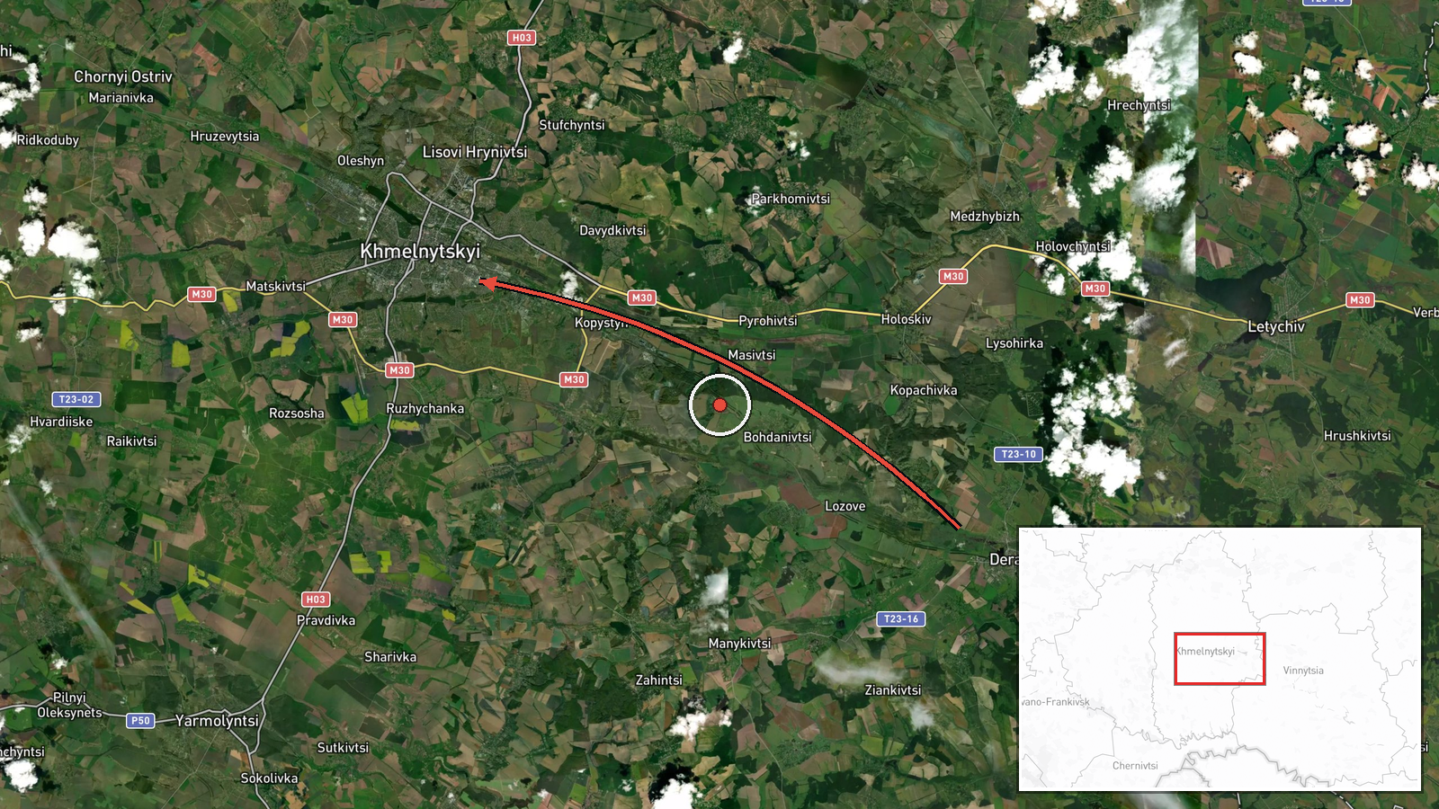
Ukrainian air monitoring reported on 17 October 2026 at 14:25 UTC that one Russian Shahed-type drone was passing Derazhnya, a settlement in Khmelnytskyi Oblast, and heading toward the city of Khmelnytskyi. The report was posted on the Telegram channel @kpszsu. The original Ukrainian wording describes the object as an 'ударний БпЛА' (strike unmanned aerial vehicle) moving 'повз Деражню у напрямку Хмельницького,' and the summary contains no information about impact, damage, casualties, or interception. The post is a movement notice rather than a strike confirmation. The event is logged as a Drone Transit with Russia named as actor, based on the Shahed-type designation in the warning. Coordinates are placed at Khmelnytskyi city, reflecting the stated destination rather than a verified position of the drone when the message was posted.
Context and assessment
Khmelnytskyi Oblast sits in western-central Ukraine, a region that has seen fewer direct strikes than the front-line east and south but has repeatedly appeared on air-alert and drone-tracking maps. The related events in this series show a run of single-drone reports across the oblast within roughly a day. Earlier entries cover a jet-powered Shahed variant, described in the data as Geran-3, heading toward Derazhnya and passing Adyn toward Starokostiantyniv, a town that hosts an airfield. Later entries track a drone moving over the oblast toward Krasyliv and then toward Khmelnytskyi itself. The repetition of similar wording and the sequence of locations suggest a consistent pattern of individual drones moving through the same corridor. Operationally, this could reflect route probing, reconnaissance of air defence coverage, or a deliberate effort to stretch warning systems across several districts. It could also reflect nothing more than improved sensor coverage, which tends to produce more individual reports without any change in attack intensity. Single-drone transit reports do not on their own establish intent, and the pattern should be read as a monitoring signal rather than evidence of a planned strike on the city.
Sources and confidence
The event rests on a single Telegram channel, @kpszsu, and the data records a source count of one with no corroborating outlet listed. The confidence score of 8.0 reflects a credible official-style monitoring feed with specific, time-stamped wording, but it is not higher because no independent confirmation is attached and the post describes only movement. Confidence would rise with matching reports from other Ukrainian air-monitoring or regional military channels, or from official statements that confirm the drone's track or any interception. It would fall if later corrections changed the track, the drone type, or the destination, or if the feed were found to repeat earlier posts. The corrected flag is currently false.
Location
The location is recorded at settlement level, with coordinates placed at the city of Khmelnytskyi and a location confidence rated high. The point reflects the named destination rather than a precise drone position, and Derazhnya appears only as a waypoint in the report. Khmelnytskyi is a regional city on the Southern Bug river in the historic Podillia area of western Ukraine. Its surroundings are mainly agricultural, with river valleys and scattered towns, and the area is generally flat to gently rolling.
Related events nearby
- Ukrainian air monitoring: 1 Russian Shahed-type drone over Khmelnytskyi Oblast.2026-10-17 14:13 UTC · Drone Transit · Khmelnytskyi Oblast, Ukraine
- Ukrainian air monitoring: 1 Russian Shahed-type drone heading toward Khmelnytskyi.2026-10-16 17:53 UTC · Drone Transit · Khmelnytskyi, Ukraine
- Ukrainian air monitoring: 1 Russian Shahed-type drone heading toward Krasyliv.2026-10-17 14:43 UTC · Drone Transit · Krasyliv, Ukraine
- Ukrainian air monitoring: 1 Russian Shahed-type drone from Khmelnytskyi Oblast toward Krasyliv.2026-10-17 06:23 UTC · Drone Transit · Krasyliv, Ukraine
- Ukrainian air monitoring: 1 Russian jet-powered Shahed (Geran-3) drone heading toward Derazhnya.2026-10-17 03:27 UTC · Drone Transit · Derazhnya, Ukraine
▶ View this event on the live map

Intel Mapper aggregates open-source reports from monitored Telegram and X channels, geolocates them, cross-checks duplicates across sources and assigns a confidence score. Entries are updated as new confirmations arrive. Read how we verify events.