Ukrainian air monitoring reports 2+ Russian Banderol cruise missiles heading toward Kryvyi Rih
What happened
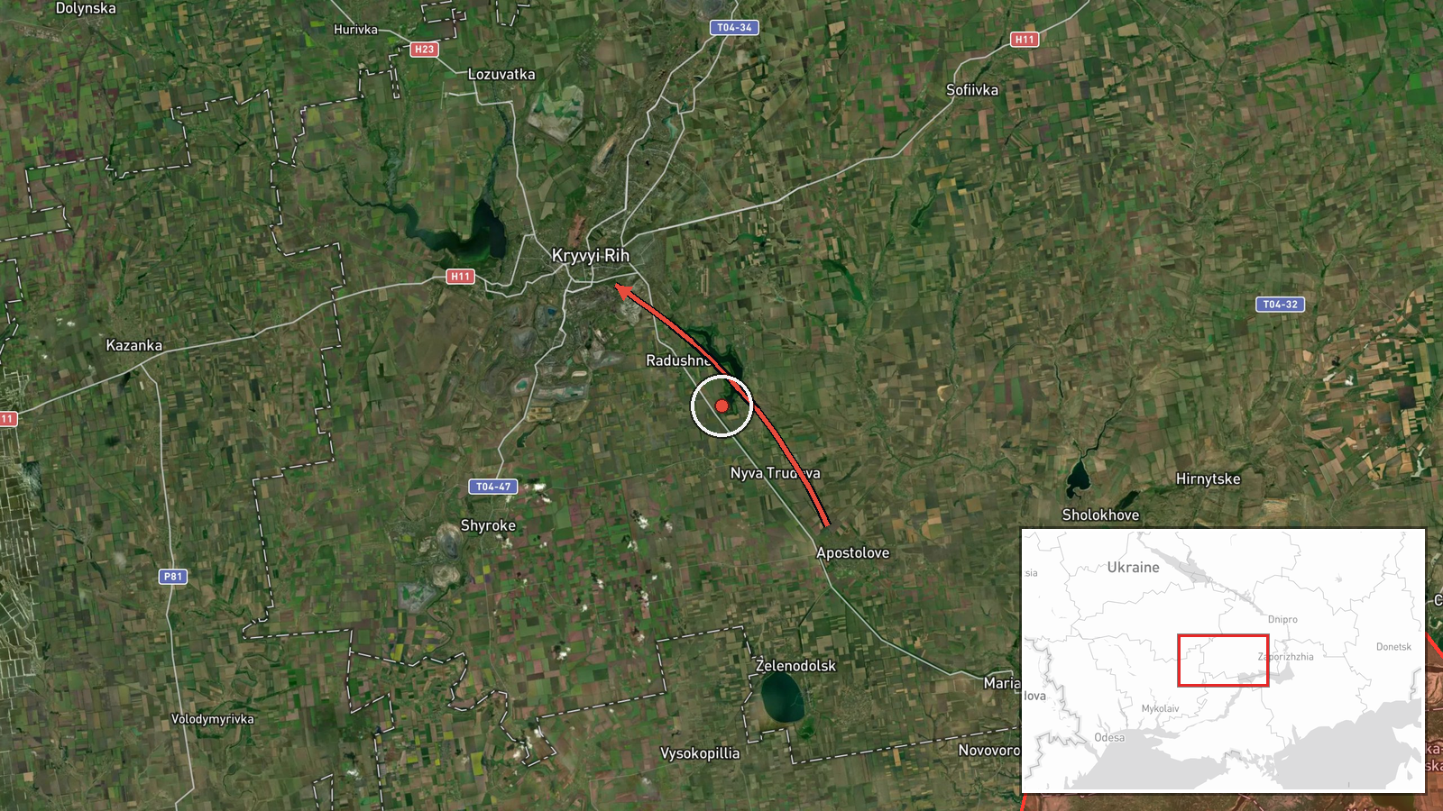
Ukrainian air monitoring, as relayed by the Telegram channel @kpszsu, reported two or more Russian Banderol mini cruise missiles passing Apostolove in Dnipropetrovsk Oblast and heading toward Kryvyi Rih. The timestamp is 18 October 2026 at 09:12 UTC. The original Ukrainian-language post describes the missiles as moving past Apostolove in the direction of Kryvyi Rih. The report does not describe impacts, casualties, or interceptions, and the event is logged as an air-threat transit warning rather than a confirmed strike. Attribution to Russia rests on the post's identification of the Banderol weapon type, which is widely associated with Russian forces. The event is recorded from a single source.
Context and assessment
Kryvyi Rih is a large industrial city of several hundred thousand residents in central Ukraine, home to heavy industry and rail and road links that matter for regional logistics. Its position on the Inhulets river corridor, along the approach from the southern Dnipropetrovsk and Mykolaiv areas, makes it a recurring point of concern in air-threat reporting. The related events show a dense pattern over the previous day in the same southern belt. Shahed-type drones were logged heading toward Bashtanka on 17 October, passing Bashtanka district westward, and again toward Novyi Buh on 17 and 18 October, with one entry describing a jet-powered Geran-3 variant. A Banderol missile was also logged heading toward Nikopol on 17 October. Taken together, these reports suggest a sustained effort to probe or saturate air defences across several oblasts rather than an isolated launch. Operationally, low-altitude cruise missiles of this class are typically harder to track than ballistic systems, so single-source transit reports of this kind often reflect partial radar or observer coverage rather than a complete picture of the flight path.
Sources and confidence
The event rests on one Telegram channel, @kpszsu, which is associated with Ukraine's air-threat reporting. No independent outlet, wire service, or second monitoring channel is cited in the data, so cross-confirmation is absent. The score of 8.0 reflects a credible, specific, and time-stamped post from an official-linked monitoring source, offset by the single-source status and the absence of any reported outcome. Confidence would rise with corroboration from another monitoring channel, Ukrainian Air Force statements, or local authority reports of activity near Kryvyi Rih. It would fall if later updates showed the missiles were misidentified or the track was not confirmed.
Location
The location is recorded at settlement precision, placing the event at the centre of Kryvyi Rih rather than at a specific facility. The reported track references Apostolove, a town in Dnipropetrovsk Oblast to the south-east of the city, indicating the missiles' approach path rather than a confirmed target. The city sits on both banks of the Inhulets river in a broad, largely flat steppe landscape with a long, narrow urban footprint.
Related events nearby
- Ukrainian air monitoring: 1 Russian jet-powered Shahed (Geran-3) drone from Mykolaiv Oblast toward Novyi Buh.2026-10-18 04:41 UTC · Drone Transit · Novyi Buh, Ukraine
- Ukrainian air monitoring: 1 Russian Shahed-type drone from Mykolaiv Oblast toward Novyi Buh.2026-10-17 13:24 UTC · Drone Transit · Novyi Buh, Ukraine
- Ukrainian air monitoring: 1 Russian Banderol mini cruise missile heading toward Nikopol.2026-10-17 11:59 UTC · Cruise Missile · Nikopol, Ukraine
- Ukrainian air monitoring: 1 Russian Shahed-type drone heading toward Bashtanka.2026-10-17 11:13 UTC · Drone Transit · Bashtanka, Ukraine
- Ukrainian air monitoring: 1 Russian Shahed-type drone passing Bashtanka district, heading west.2026-10-17 11:08 UTC · Drone Transit · Bashtanka district, Ukraine
▶ View this event on the live map

Intel Mapper aggregates open-source reports from monitored Telegram and X channels, geolocates them, cross-checks duplicates across sources and assigns a confidence score. Entries are updated as new confirmations arrive. Read how we verify events.