Ukrainian monitors report one jet-powered Geran-3 drone moving toward Donets from Kharkiv Oblast
What happened
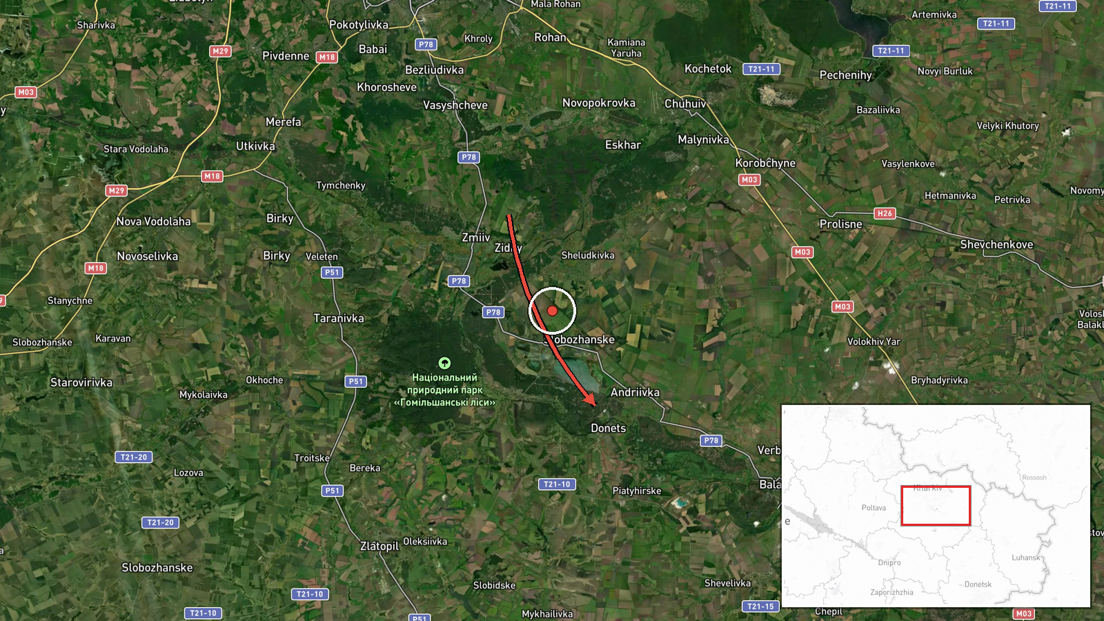
Ukraine's air monitoring service reported one Russian jet-powered Shahed (Geran-3) drone traveling toward the settlement of Donets, approaching from the south in Kharkiv Oblast. The original Ukrainian-language post, published on the Telegram channel @kpszsu, describes it as a jet-type UAV heading to Donets from the south in the Kharkiv region. The report gives a timestamp of 19 October 2026 at 02:53 UTC and does not mention impacts, casualties, or damage. Because the post reports a flight path rather than an outcome, the event records the drone's transit and not a confirmed strike.
Context and assessment
Donets sits in the Kharkiv Oblast, the northeastern Ukrainian region that has seen repeated Russian drone traffic and ground pressure in recent months. The related events show a sequence on 18 October in which the same drone type was tracked heading toward Kharkiv, then over Izyum, over Lozova, and toward Valky, moving through the region in a roughly consecutive pattern. The same day, Ukraine's General Staff reported six Russian assault attempts on the Kupiansk axis, which lies to the east of Kharkiv. Taken together, the sequence suggests that the drones are being used along a corridor that crosses multiple districts rather than targeting a single point. Operationally, such transits are often read as reconnaissance, route-testing, or preparation for strikes on logistics, energy, or rail infrastructure, though a flight report alone cannot establish which purpose applies. Any link to the ground fighting near Kupiansk should be treated as a possibility, not a confirmed connection.
Sources and confidence
The event rests on a single Telegram channel, @kpszsu, which is widely associated with Ukraine's Air Force air-monitoring reporting. No second channel, regional military administration, or independent observer has yet confirmed this specific transit in the data provided. The confidence score of 8.0 reflects an official-sounding source with a clear, specific report, offset by the absence of cross-confirmation and the lack of any outcome data. Confidence would rise if Kharkiv regional authorities, other Ukrainian air-monitoring channels, or open-source flight trackers corroborated the track. It would fall if the report were revised, if the track was attributed to a different drone, or if later reporting contradicted the timing or location.
Location
The location is recorded at settlement precision, with a high location-confidence rating, meaning the coordinates point to the named village rather than to a broader district. The point sits in the Kharkiv Oblast, roughly 55 to 60 kilometers south-southeast of Kharkiv city by approximate coordinates. The landscape is mostly open steppe and farmland interspersed with forest belts and river valleys. The name is close to the Donets river system, and the Siverskyi Donets valley runs through the wider region. Settlement-level placement is adequate for mapping the event, but exact street-level or facility-level targeting cannot be inferred from the data.
Related events nearby
- Ukrainian air monitoring: 1 Russian jet-powered Shahed (Geran-3) drone from Kharkiv Oblast toward Zlatopil.2026-10-19 03:23 UTC · Drone Transit · Zlatopil, Ukraine
- Ukrainian air monitoring: 1 Russian jet-powered Shahed (Geran-3) drone heading toward Kharkiv.2026-10-19 03:12 UTC · Drone Transit · Kharkiv, Ukraine
- Ukrainian air monitoring: 1 Russian jet-powered Shahed (Geran-3) drone heading toward Kharkiv.2026-10-18 03:31 UTC · Drone Transit · Kharkiv, Ukraine
- Ukrainian air monitoring: 1 Russian Shahed-type drone over Izyum.2026-10-18 06:59 UTC · Drone Transit · Izyum, Ukraine
- Ukrainian air monitoring: 1 Russian jet-powered Shahed (Geran-3) drone over Lozova.2026-10-18 07:52 UTC · Drone Transit · Lozova, Ukraine
▶ View this event on the live map

Intel Mapper aggregates open-source reports from monitored Telegram and X channels, geolocates them, cross-checks duplicates across sources and assigns a confidence score. Entries are updated as new confirmations arrive. Read how we verify events.