Ukrainian air monitoring reports jet-powered Shahed drones heading toward Tyvriv, Vinnytsia Oblast
What happened
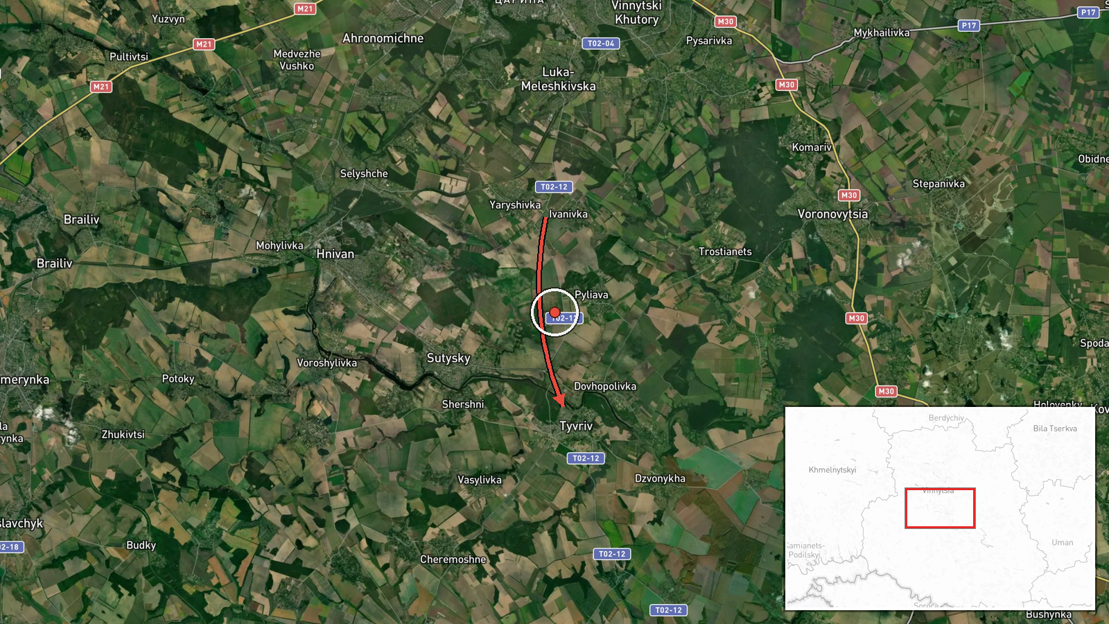
On 19 October 2026 at about 07:45 UTC, the Telegram channel @kpszsu, which carries Ukrainian air monitoring alerts, reported two or more Russian jet-powered Shahed (Geran-3) drones approaching from the east toward Tyvriv and Rakhny-Lisovi in Vinnytsia Oblast. The original Ukrainian wording, 'Реактивні БпЛА курсом на Тиврів та Рахни-Лісові на Вінниччині зі сходу,' names both settlements, but the event record geocodes only Tyvriv. The post reports the heading and approach direction only. It does not describe impacts, casualties, or interceptions, and no independent outlet has yet confirmed the track.
Context and assessment
Tyvriv sits in Vinnytsia Oblast, a central-western region that Russian long-range drones have repeatedly crossed on routes toward western and central Ukraine. The related reports form a pattern. Earlier that morning, a single Geran-3 was logged in eastern Vinnytsia Oblast heading north at 04:12 UTC, then one near Vinnytsia city at 05:22, one approaching Zhmerynka at 05:17, and one near Tulchyn at 06:37. The previous evening, a Banderol mini cruise missile was reported heading toward Kalynivka. Taken together, these reports suggest sustained, multi-axis activity across the oblast over several hours rather than a single isolated transit. Operationally, repeated single-drone tracks in different directions may reflect reconnaissance of air defence coverage, route probing, or a deliberate effort to stretch monitoring and interception resources. Those explanations cannot be distinguished from this single report alone.
Sources and confidence
Only one source is cited: the Telegram channel @kpszsu. The post is timestamped, uses Ukrainian air monitoring terminology, and matches a chain of related alerts from the same regional sequence, which supports its plausibility. However, no official statement, regional administration notice, or independent observer has corroborated it, and the report includes no impact or interception details. The confidence score of 8.0 reflects a credible monitoring channel with consistent related reports but no cross-confirmation. Confirmation from Ukrainian Air Force statements, regional military administration updates, or reports of interceptions or debris would raise confidence. Silence from official channels or a lack of corroborating sightings would lower it.
Location
The event is geocoded at settlement level, with high location confidence, for the centre of Tyvriv in Vinnytsia Oblast. Rakhny-Lisovi is named in the original post but is not separately geocoded here. The area is part of the agricultural plains of central-western Ukraine, where open farmland, scattered villages, and river valleys in the wider Southern Bug basin make low-altitude drone tracking difficult. Precise coordinates for any impact point are not available.
Related events nearby
- Ukrainian air monitoring: 1 Russian jet-powered Shahed (Geran-3) drone heading toward Vinnytsia.2026-10-19 05:22 UTC · Drone Transit · Vinnytsia, Ukraine
- Ukrainian air monitoring: 1 Russian jet-powered Shahed (Geran-3) drone passing Voronovytsya, heading toward Zh2026-10-19 05:17 UTC · Drone Transit · Zhmerynka, Ukraine
- Ukrainian air monitoring: 1 Russian jet-powered Shahed (Geran-3) drone passing Haysyn, heading toward Tulchyn.2026-10-19 06:37 UTC · Drone Transit · Tulchyn, Ukraine
- Ukrainian air monitoring: 1 Russian Banderol mini cruise missile heading toward Kalynivka.2026-10-18 19:18 UTC · Cruise Missile · Kalynivka, Ukraine
- Ukrainian air monitoring: 1 Russian jet-powered Shahed (Geran-3) drone passing eastern Vinnytsia Oblast, headi2026-10-19 04:12 UTC · Drone Transit · eastern Vinnytsia Oblast, Ukraine
▶ View this event on the live map

Intel Mapper aggregates open-source reports from monitored Telegram and X channels, geolocates them, cross-checks duplicates across sources and assigns a confidence score. Entries are updated as new confirmations arrive. Read how we verify events.