Single Russian Shahed-type drone reported transiting Vinnytsia Oblast toward Vinnytsia city
What happened
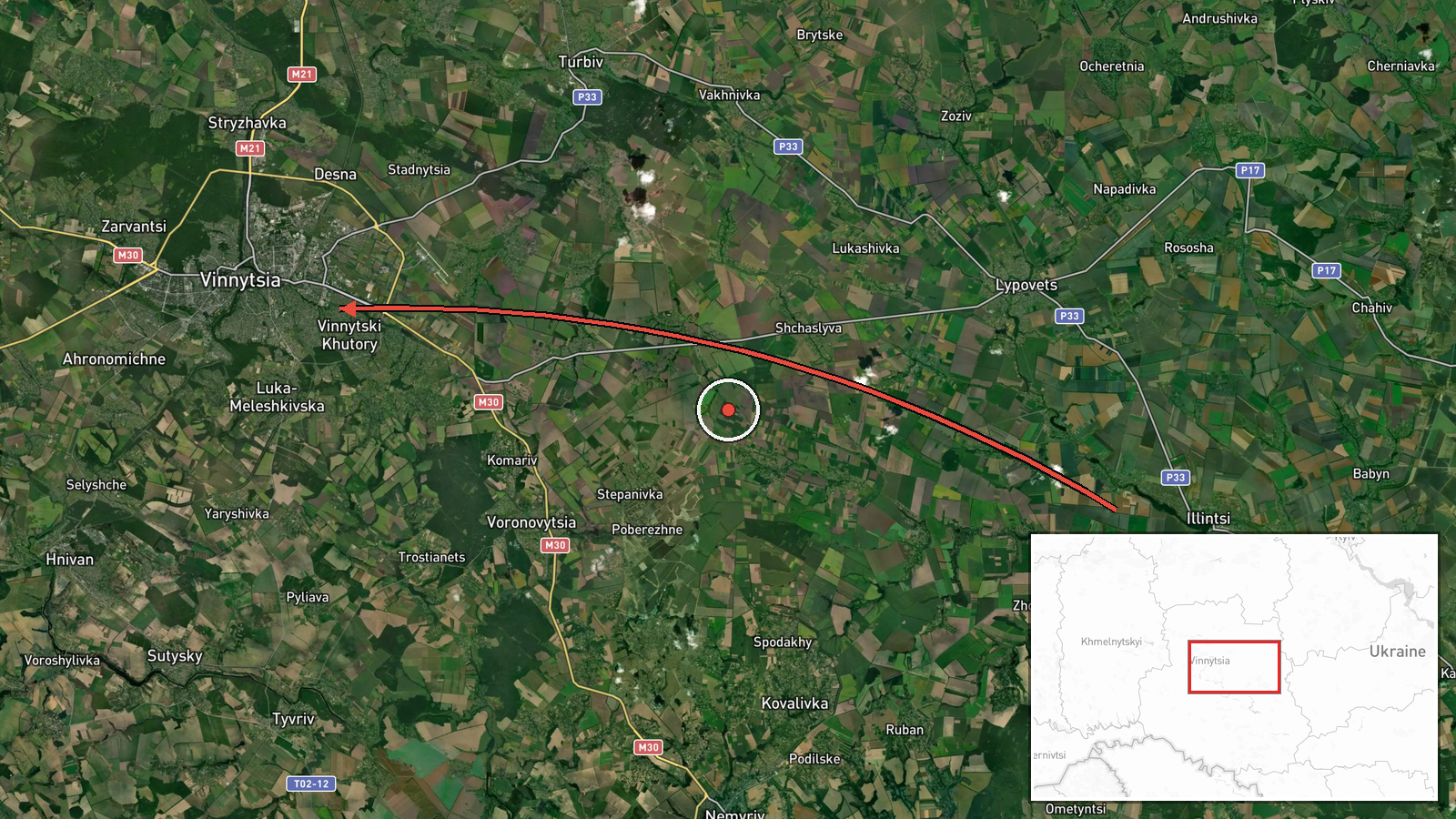
Ukrainian air monitoring channel @kpszsu reported on Telegram that one Russian Shahed-type drone was passing Illintsi, a settlement in Vinnytsia Oblast, heading toward the city of Vinnytsia. The report was timestamped at 01:23 UTC on 20 October 2026. The original Ukrainian wording, 'Повз Іллінці у напрямку Вінниці', is terse and identifies the drone's track rather than any impact or damage. No strike, casualties or debris recovery are mentioned in the source. The alert is one of a series of air-monitoring notices for the oblast in the preceding hours, and it is logged as a transit rather than an attack.
Context and assessment
Vinnytsia Oblast sits in west-central Ukraine, on the routes that Russian long-range drones have increasingly used to cross from the south and east toward western and northwestern targets. Related entries in the same feed show a steady pattern over the previous several hours: drones from Odesa and Kirovohrad oblasts moving toward Vinnytsia, followed by single drones heading north and northwest. Several of these entries describe jet-powered Geran-3 variants, which the feed consistently labels as Shahed-type. The repetition suggests Russian operators were routing drones through the oblast in successive waves, possibly to reach targets further north or west, or to stretch Ukrainian air defence and warning systems. Transit reports of this kind are a common indicator of a broader strike campaign, although a single track by itself does not reveal the intended target. Analysts would expect the picture to become clearer only if later reports confirm a detonation, interception or a change in heading.
Sources and confidence
The event rests on one Telegram channel, @kpszsu, which is the Ukrainian air force's official monitoring account. Its reports are generally timely and used widely, but this entry is a single-source notice with no independent confirmation from another outlet, local authority or wire service at the time of recording. The confidence score of 8.0 reflects an official source with a clear, specific track description, offset by the absence of cross-confirmation and by the brevity of the wording. Confidence would rise with corroboration from regional military administration statements, an interception or impact report, or matching related entries that name the same drone track. It would fall if the track were later revised, corrected or withdrawn by the issuing channel.
Location
The location is recorded at settlement level, pinned to Illintsi, a small settlement in Vinnytsia Oblast, with coordinates of approximately 49.23 N, 28.47 E. The source names the settlement directly, so the placement is considered high confidence, though it marks the drone's position at the time of the report rather than a target. The area is mostly agricultural lowland of the Podolia region, with rivers such as the Southern Bug and its tributaries crossing the broader oblast. Vinnytsia city, the stated heading, lies to the northwest of the pin.
Related events nearby
- Ukrainian air monitoring: 1 Russian jet-powered Shahed (Geran-3) drone passing Vinnytsia Oblast, heading north2026-10-20 01:20 UTC · Drone Transit · Vinnytsia Oblast, Ukraine
- Ukrainian air monitoring: 1 Russian jet-powered Shahed (Geran-3) drone passing Vinnytsia Oblast, heading north2026-10-20 01:14 UTC · Drone Transit · Vinnytsia Oblast, Ukraine
- Ukrainian air monitoring: 2+ Russian jet-powered Shahed (Geran-3) drones from Kirovohrad Oblast toward Vinnyts2026-10-19 23:35 UTC · Drone Transit · Vinnytsia Oblast, Ukraine
- Ukrainian air monitoring: 2+ Russian jet-powered Shahed (Geran-3) drones from northern Odesa Oblast toward Vin2026-10-19 23:06 UTC · Drone Transit · Vinnytsia Oblast, Ukraine
- Ukrainian air monitoring: 1 Russian jet-powered Shahed (Geran-3) drone from Odesa Oblast toward Vinnytsia Obla2026-10-19 17:50 UTC · Drone Transit · Vinnytsia Oblast, Ukraine
▶ View this event on the live map

Intel Mapper aggregates open-source reports from monitored Telegram and X channels, geolocates them, cross-checks duplicates across sources and assigns a confidence score. Entries are updated as new confirmations arrive. Read how we verify events.