Two Geran-3 jet drones reported transiting Vinnytsia Oblast from Odesa and Cherkasy
What happened
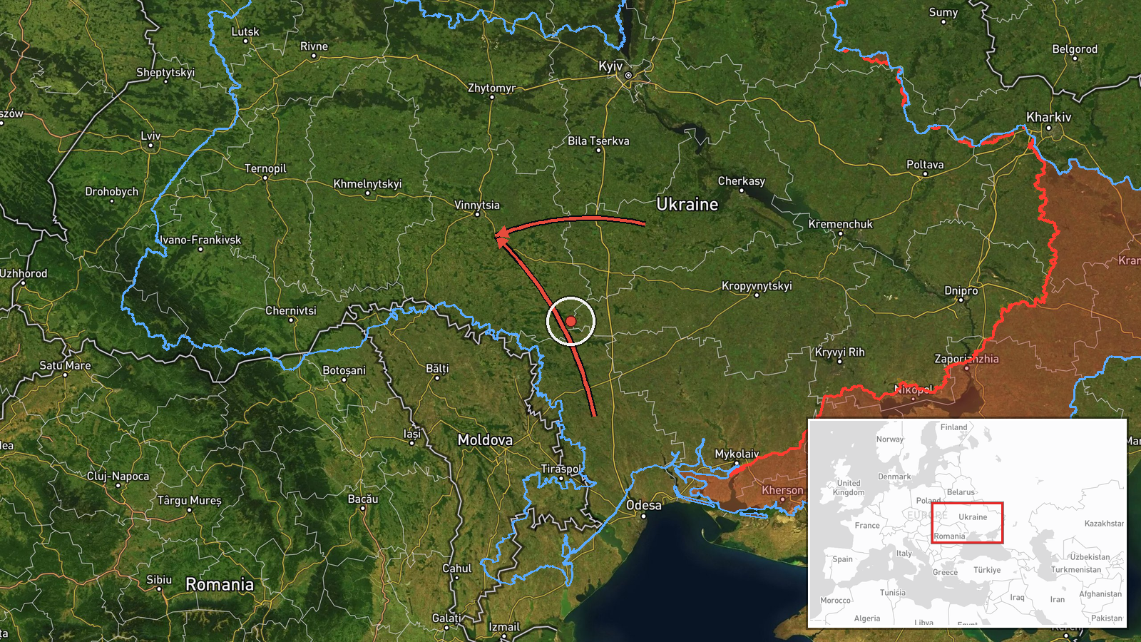
Ukrainian air monitoring reported on 19 October 2026, at about 17:50 UTC, that one Russian jet-powered Shahed (Geran-3) drone was moving from Odesa Oblast toward Vinnytsia Oblast, and a second from Cherkasy Oblast toward eastern Vinnytsia Oblast. The report was posted on the Telegram channel @kpszsu and uses the Ukrainian phrasing for a jet-type UAV transit between regions, not a confirmed strike. The post names no impact site, casualties, or damage, and gives no specific settlement. Both drones are described as moving through the oblast, so the report documents airspace activity rather than a point of attack. The source wording is terse and operational, and the regional framing is the channel's own.
Context and assessment
Vinnytsia Oblast sits in west-central Ukraine, between the Odesa and Cherkasy approaches and the Kyiv and Zhytomyr regions, so it is regularly crossed by long-range drones moving north and west from southern and central launch corridors. The same day shows a pattern of repeated transits. Earlier reports placed one drone heading toward Vinnytsia at 05:22, another passing Voronovytsya toward Zhmerynka at 05:17, and a group of two or more moving from Vinnytsia Oblast toward Tyvriv at 07:45. A group of two or more also came from Odesa Oblast toward Vinnytsia Oblast at 14:04. The previous evening, a Banderol mini cruise missile was reported heading toward Kalynivka. Taken together, the sequence suggests the oblast is being traversed by a steady stream of jet-powered Shaheds, possibly routed toward targets further west or north, or used to stretch air defences. Those readings are inferences from timing and direction, not confirmed intent, and the reports do not establish where any drone ended its flight.
Sources and confidence
The event rests on a single channel, Telegram @kpszsu, and no independent outlet or second monitoring feed is listed for this report. Confidence is scored at 8.0, which is relatively high because the channel is an official Ukrainian air-monitoring source with a consistent record of timestamped transit notices. It is held below the maximum because the post is unconfirmed by other channels and gives no sensor detail. Confidence would rise with corroboration from additional Ukrainian authorities, regional administrations, or independent trackers, or with an official impact report. It would fall if later updates revised the drone counts, the routes, or the timing.
Location
The location is recorded only at oblast level, Vinnytsia Oblast, and is marked as region precision with low location confidence. The coordinates of 49.23 N, 28.47 E are an approximate central point for the oblast rather than a settlement or facility. Vinnytsia Oblast is largely rolling farmland and forest-steppe in the Dnipro-Dniester interfluve, with the Southern Bug River flowing through its territory. The eastern portion, which the report names, lies closer to the Cherkasy border.
Related events nearby
- Ukrainian air monitoring: 2+ Russian jet-powered Shahed (Geran-3) drones from Odesa Oblast toward Vinnytsia Ob2026-10-19 14:04 UTC · Drone Transit · Vinnytsia Oblast, Ukraine
- Ukrainian air monitoring: 1 Russian jet-powered Shahed (Geran-3) drone heading toward Vinnytsia.2026-10-19 05:22 UTC · Drone Transit · Vinnytsia, Ukraine
- Ukrainian air monitoring: 2+ Russian jet-powered Shahed (Geran-3) drones from Vinnytsia Oblast toward Tyvriv.2026-10-19 07:45 UTC · Drone Transit · Tyvriv, Ukraine
- Ukrainian air monitoring: 1 Russian Banderol mini cruise missile heading toward Kalynivka.2026-10-18 19:18 UTC · Cruise Missile · Kalynivka, Ukraine
- Ukrainian air monitoring: 1 Russian jet-powered Shahed (Geran-3) drone passing Voronovytsya, heading toward Zh2026-10-19 05:17 UTC · Drone Transit · Zhmerynka, Ukraine
▶ View this event on the live map

Intel Mapper aggregates open-source reports from monitored Telegram and X channels, geolocates them, cross-checks duplicates across sources and assigns a confidence score. Entries are updated as new confirmations arrive. Read how we verify events.