Russian jet-powered Shahed drones reported transiting Vinnytsia Oblast from Odesa Oblast
What happened
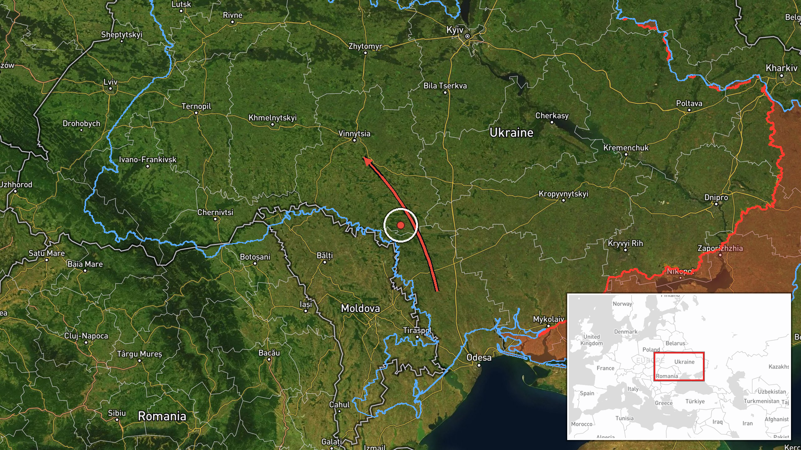
Ukrainian air monitoring reported on 20 October 2026 at 08:13 UTC that two or more Russian jet-powered Shahed (Geran-3) drones were moving from Odesa Oblast toward Vinnytsia Oblast in west-central Ukraine. The report, published on the Telegram channel @kpszsu, is a flight-track notice rather than a strike report. It describes the drones passing near Ananiv in Odesa Oblast on a course toward Vinnytsia Oblast. The original Ukrainian wording refers to jet-type unmanned aerial vehicles, and the 'Geran-3' designation in the summary is the model name for that jet-powered variant. The source describes no impact, casualties or damage. The entry is classified as a drone transit, with Russia named as the actor on the basis of the aircraft type.
Context and assessment
Vinnytsia Oblast lies in west-central Ukraine, on the Southern Bug river, and it sits along the route that long-range drones take when moving from the south toward western Ukraine. The related entries show that this was not a single pass. Earlier that morning, monitoring logged a lone jet-powered drone near Illintsi at 01:23 UTC heading toward Vinnytsia, then a single drone at 03:14 UTC, a group of two or more at 05:49 UTC, and a drone passing Podilsk district at 07:29 UTC, all before the 08:13 update. Several entries record drones heading west, which suggests the flights were moving through the oblast rather than aimed at one fixed site. Taken together, the sequence may indicate routing of drones across central Ukraine, or an effort to keep regional air defense and warning systems tracking multiple tracks over several hours. Transit reports alone do not establish the intended target, and a tracked drone may later be lost, diverted or reach a different area. The pattern is worth comparing against any subsequent impact reports from the region.
Sources and confidence
Only one channel reported this entry: the Telegram account @kpszsu, which carries Ukrainian air monitoring updates. The source count is one. The confidence score of 8.0 reflects a clear, time-stamped report from a government-linked monitoring source, but it is held below the top of the scale because nothing in the data independently confirms it. Confidence would rise with matching reports from other Ukrainian air force or regional administration channels, or from wire services relaying the same notice. It would fall if later updates revised the number of drones, their direction of travel or the oblast involved.
Location
The location is recorded at region level, Vinnytsia Oblast, with an approximate central point of 49.23 N, 28.47 E rather than a specific settlement, which is why location confidence is low. The original message places the track near Ananiv in Odesa Oblast, and related entries name Illintsi and Podilsk district as points on the approach. The area is largely agricultural and rolling, drained by the Southern Bug, with few fixed landmarks that would support a precise position for a transit report.
Related events nearby
- Ukrainian air monitoring: 1 Russian jet-powered Shahed (Geran-3) drone passing Vinnytsia Oblast, heading west.2026-10-20 08:13 UTC · Drone Transit · Vinnytsia Oblast, Ukraine
- Ukrainian air monitoring: 1 Russian jet-powered Shahed (Geran-3) drone passing Podilsk district, heading towar2026-10-20 07:29 UTC · Drone Transit · Vinnytsia Oblast, Ukraine
- Ukrainian air monitoring: 2+ Russian jet-powered Shahed (Geran-3) drones passing Vinnytsia Oblast, heading wes2026-10-20 05:49 UTC · Drone Transit · Vinnytsia Oblast, Ukraine
- Ukrainian air monitoring: 1 Russian jet-powered Shahed (Geran-3) drone passing Vinnytsia Oblast, heading west.2026-10-20 03:14 UTC · Drone Transit · Vinnytsia Oblast, Ukraine
- Ukrainian air monitoring: 1 Russian Shahed-type drone passing Illintsi, heading toward Vinnytsia.2026-10-20 01:23 UTC · Drone Transit · Vinnytsia, Ukraine
▶ View this event on the live map

Intel Mapper aggregates open-source reports from monitored Telegram and X channels, geolocates them, cross-checks duplicates across sources and assigns a confidence score. Entries are updated as new confirmations arrive. Read how we verify events.