Ukrainian Air Force reports one Russian Geran-3 drone transiting Podilsk toward Vinnytsia Oblast
What happened
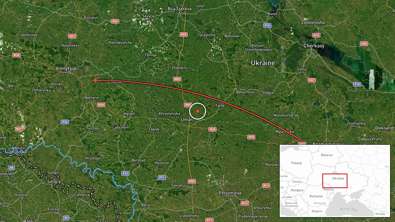
Ukraine's Air Force, reported through its Telegram channel @kpszsu, said at about 07:29 UTC on 20 October 2026 that one Russian jet-powered Shahed (Geran-3) drone was flying through Podilsk district and heading toward Vinnytsia Oblast. The original Ukrainian-language post opens with the word Odeshchyna, meaning Odesa region, and places the drone in the Podilsk district of that region before its course toward Vinnytsia. The event summary describes the same drone passing Podilsk district without naming the oblast, while the event's coordinates sit within Vinnytsia Oblast. The report describes a transit, not a strike, and mentions no impact, casualties or damage.
Context and assessment
Vinnytsia Oblast lies in west-central Ukraine, and drones crossing it are typically moving toward targets farther west or north. The related events in this feed show a dense sequence of transits over the oblast on the same day. Between 01:14 and 01:23 UTC, reports described single Geran-3 contacts heading northwest and north, and a Shahed-type drone approaching Vinnytsia city. At 03:14 a single jet-powered drone was reported heading west, and at 05:49 two or more drones were reported heading west. The 07:29 report fits that pattern, with a drone entering from the south-west and turning toward the oblast. Operationally, repeated transit reports of this kind may point to drones being routed toward western targets, or to diversionary flights, but the feed alone cannot show which. Jet-powered Geran-3 variants are generally assessed as faster and harder to intercept than piston-engine Shahed-136 models, which is one reason their movements draw close tracking. The sequence suggests sustained activity rather than a single flight, but the data does not establish whether it reflects a coordinated campaign or routine launches.
Sources and confidence
The report rests on a single channel, the Telegram account @kpszsu, which carries Ukrainian Air Force air-alert and monitoring updates and is widely followed as an official source. No second outlet, radar record or independent observer confirms the sighting in the data provided. The score of 8.0 reflects the official origin and the specific model identification, but it is held below the top of the scale because the report is single-sourced and its location details conflict: the post names Odesa region while the coordinates fall in Vinnytsia Oblast. Confidence would rise with a corroborating air force statement, a regional military administration notice, or matching reports from Odesa or Vinnytsia authorities. It would fall if the oblast attribution is confirmed as an error or if the report is corrected.
Location
The location is recorded at region precision, so the coordinates (49.23 N, 28.47 E) mark an approximate point in Vinnytsia Oblast rather than a settlement or facility, and location confidence is rated low. The original post places the sighting in Podilsk district of Odesa region, which lies south-west of the coordinates, so they should be read as a general area and not the drone's exact position. The terrain is mainly agricultural plains cut by river valleys, including the Southern Bug, which runs through both oblasts.
Related events nearby
- Ukrainian air monitoring: 2+ Russian jet-powered Shahed (Geran-3) drones passing Vinnytsia Oblast, heading wes2026-10-20 05:49 UTC · Drone Transit · Vinnytsia Oblast, Ukraine
- Ukrainian air monitoring: 1 Russian jet-powered Shahed (Geran-3) drone passing Vinnytsia Oblast, heading west.2026-10-20 03:14 UTC · Drone Transit · Vinnytsia Oblast, Ukraine
- Ukrainian air monitoring: 1 Russian Shahed-type drone passing Illintsi, heading toward Vinnytsia.2026-10-20 01:23 UTC · Drone Transit · Vinnytsia, Ukraine
- Ukrainian air monitoring: 1 Russian jet-powered Shahed (Geran-3) drone passing Vinnytsia Oblast, heading north2026-10-20 01:20 UTC · Drone Transit · Vinnytsia Oblast, Ukraine
- Ukrainian air monitoring: 1 Russian jet-powered Shahed (Geran-3) drone passing Vinnytsia Oblast, heading north2026-10-20 01:14 UTC · Drone Transit · Vinnytsia Oblast, Ukraine
▶ View this event on the live map

Intel Mapper aggregates open-source reports from monitored Telegram and X channels, geolocates them, cross-checks duplicates across sources and assigns a confidence score. Entries are updated as new confirmations arrive. Read how we verify events.