Air monitoring: 2+ jet-powered Shahed drones moving from Odesa Oblast toward Vinnytsia Oblast
What happened
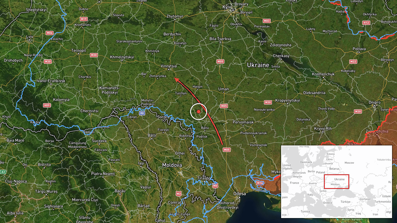
Ukrainian air monitoring, as relayed by the Telegram channel @kpszsu, reported two or more Russian jet-powered Shahed (Geran-3) drones moving from northern Odesa Oblast toward Vinnytsia Oblast. The post is timed 23:06 UTC on 19 October 2026. The original Ukrainian wording, 'Реактивні БпЛА на півночі Одещини у напрямку Вінниччини', describes jet-powered unmanned aerial vehicles in the north of the Odesa region heading in the direction of Vinnytsia. The notice names no settlement, no time of arrival, no target and no outcome. It is a transit warning from air monitoring rather than a confirmed strike, and the attribution to Russia rests on the Geran-3 designation used in the report.
Context and assessment
This notice is one of five drone transit reports for Vinnytsia Oblast issued on 19 October 2026, running from 05:17 to 23:06 UTC. The sequence moves through several local points, including Zhmerynka, Voronovytsya, Tyvriv and Vinnytsia itself, which suggests that the drones were tracked as they crossed the oblast rather than appearing at one spot. Zhmerynka is a significant railway junction, and Vinnytsia is a major regional centre with road and rail links, so the corridor carries logistical and infrastructure weight. Geran-3 is generally described as the jet-powered variant of the Shahed family, reportedly faster and harder to intercept than the older piston-engined models. Taken together, repeated transits across the same oblast may indicate sustained flights through central Ukraine toward targets further west or north, but the reports alone do not establish what those targets were. Each report is a sighting of movement, and none of them confirms intent or impact.
Sources and confidence
All information comes from a single Telegram channel, @kpszsu, and no second outlet is listed, so the source count is one. The confidence score of 8.0 reflects the channel's role in publishing air monitoring updates and the regular cadence of its earlier posts, which makes the basic report of drone movement plausible. It is held below the top of the scale because the post has no independent cross-confirmation and no reported impact. Confidence would rise with corroboration from regional military administrations, further Air Force statements, or reports of interceptions or debris in the area. It would fall if later updates revised the drone count, changed the direction of travel, or contradicted the report.
Location
The location is recorded only at region level, and the coordinates (49.23, 28.47) mark an approximate centre of Vinnytsia Oblast, not a specific settlement or facility. Location confidence is low because the report names no place where the drones were observed. Vinnytsia Oblast lies in west-central Ukraine, in the historic Podillia region. Its terrain is largely rolling farmland and river valleys, with the Southern Bug River running through the territory. The oblast borders Odesa Oblast to the south.
Related events nearby
- Ukrainian air monitoring: 2+ Russian jet-powered Shahed (Geran-3) drones from Kirovohrad Oblast toward Vinnyts2026-10-19 23:35 UTC · Drone Transit · Vinnytsia Oblast, Ukraine
- Ukrainian air monitoring: 1 Russian jet-powered Shahed (Geran-3) drone from Odesa Oblast toward Vinnytsia Obla2026-10-19 17:50 UTC · Drone Transit · Vinnytsia Oblast, Ukraine
- Ukrainian air monitoring: 2+ Russian jet-powered Shahed (Geran-3) drones from Odesa Oblast toward Vinnytsia Ob2026-10-19 14:04 UTC · Drone Transit · Vinnytsia Oblast, Ukraine
- Ukrainian air monitoring: 1 Russian jet-powered Shahed (Geran-3) drone heading toward Vinnytsia.2026-10-19 05:22 UTC · Drone Transit · Vinnytsia, Ukraine
- Ukrainian air monitoring: 2+ Russian jet-powered Shahed (Geran-3) drones from Vinnytsia Oblast toward Tyvriv.2026-10-19 07:45 UTC · Drone Transit · Tyvriv, Ukraine
▶ View this event on the live map

Intel Mapper aggregates open-source reports from monitored Telegram and X channels, geolocates them, cross-checks duplicates across sources and assigns a confidence score. Entries are updated as new confirmations arrive. Read how we verify events.