Ukrainian air alert tracks jet-powered Geran-3 drone toward Shepetivka, Khmelnytskyi Oblast
What happened
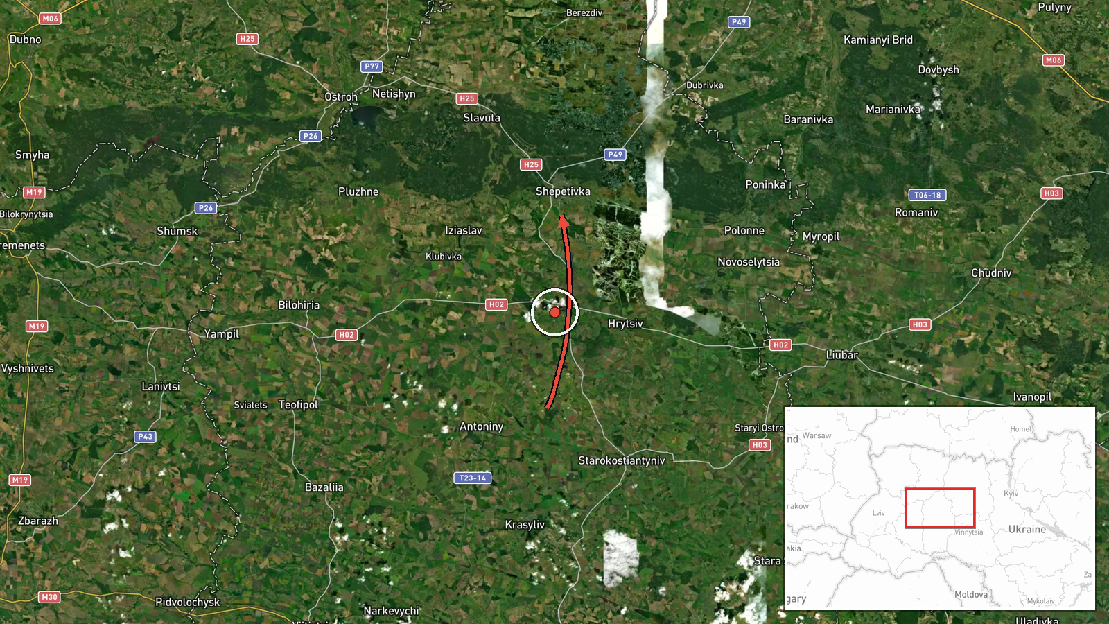
Ukraine's air force monitoring channel on Telegram (@kpszsu) reported one Russian jet-powered Shahed, designated Geran-3, moving from Khmelnytskyi Oblast toward Shepetivka, a city in western-central Ukraine. The original Ukrainian post, a brief alert, described the drone as approaching Shepetivka from the north. The report is timestamped 14:02 UTC on 19 October 2026 and is recorded as a drone transit rather than a confirmed impact. The alert does not mention explosions, damage, casualties, or whether the drone was intercepted or continued flight. Because the wording describes a track rather than a strike, this entry should be read as a monitored airspace movement only.
Context and assessment
Shepetivka matters mainly as a rail junction on lines linking Kyiv with western Ukraine, so a drone track over the town indicates that long-range Shahed-type systems are reaching deep into the northwest. Five other entries from the same day form a visible pattern. Between 02:41 and 07:31 UTC, separate alerts placed drones south of Berezne, over Adyn toward Rivne, and across eastern Rivne Oblast, all heading west. Two further alerts placed drones leaving Zhytomyr Oblast, one toward Liubar and one toward eastern Rivne Oblast. The Shepetivka report fits this sequence and reads as part of the same westward corridor, with several airframes apparently routed through the northwest on different tracks. Operationally, a spread like this may point to multiple launch waves or to routing designed to stretch air defense coverage, but the data does not confirm launch sites, intent, or targets. Jet-powered Geran-3 variants are generally faster and harder to intercept than older piston-engine Shaheds, which is why alerts of this type matter for regional air defense planning. Each track should be treated as an individual report.
Sources and confidence
All information comes from a single Telegram channel, @kpszsu, which relays Ukrainian air monitoring alerts. No second channel, wire agency, or official statement in the dataset independently confirms this specific track. Confidence is scored at 8.0 because the channel is associated with Ukraine's air force and has issued a consistent stream of alerts, and the related events describe the same drone type and corridor. However, the report is single-sourced and describes no impact. Confidence would rise with independent corroboration, such as regional military administration statements or photographs of debris, and would fall if later alerts conflicted with the reported heading or if the channel issued a correction.
Location
The coordinates correspond to Shepetivka, a settlement in Khmelnytskyi Oblast, and are placed at settlement-level precision with high location confidence because the alert names the town directly. The point marks the town rather than any specific facility. Shepetivka lies in northwestern Ukraine on the rail corridor between Kyiv and Lviv, set in flat, agricultural terrain typical of the region.
Related events nearby
- Ukrainian air monitoring: 1 Russian jet-powered Shahed (Geran-3) drone from northern Vinnytsia Oblast toward S2026-10-19 14:45 UTC · Drone Transit · Starokostyantyniv, Ukraine
- Ukrainian air monitoring: 1 Russian jet-powered Shahed (Geran-3) drone passing eastern Rivne Oblast, heading w2026-10-19 03:33 UTC · Drone Transit · eastern Rivne Oblast, Ukraine
- Ukrainian air monitoring: 1 Russian jet-powered Shahed (Geran-3) drone from Zhytomyr Oblast toward eastern Riv2026-10-19 02:57 UTC · Drone Transit · eastern Rivne Oblast, Ukraine
- Ukrainian air monitoring: 1 Russian jet-powered Shahed (Geran-3) drone from Zhytomyr Oblast toward Liubar.2026-10-19 14:00 UTC · Drone Transit · Liubar, Ukraine
- Ukrainian air monitoring: 1 Russian jet-powered Shahed (Geran-3) drone passing south of Berezne, heading west.2026-10-19 02:41 UTC · Drone Transit · south of Berezne, Ukraine
▶ View this event on the live map

Intel Mapper aggregates open-source reports from monitored Telegram and X channels, geolocates them, cross-checks duplicates across sources and assigns a confidence score. Entries are updated as new confirmations arrive. Read how we verify events.