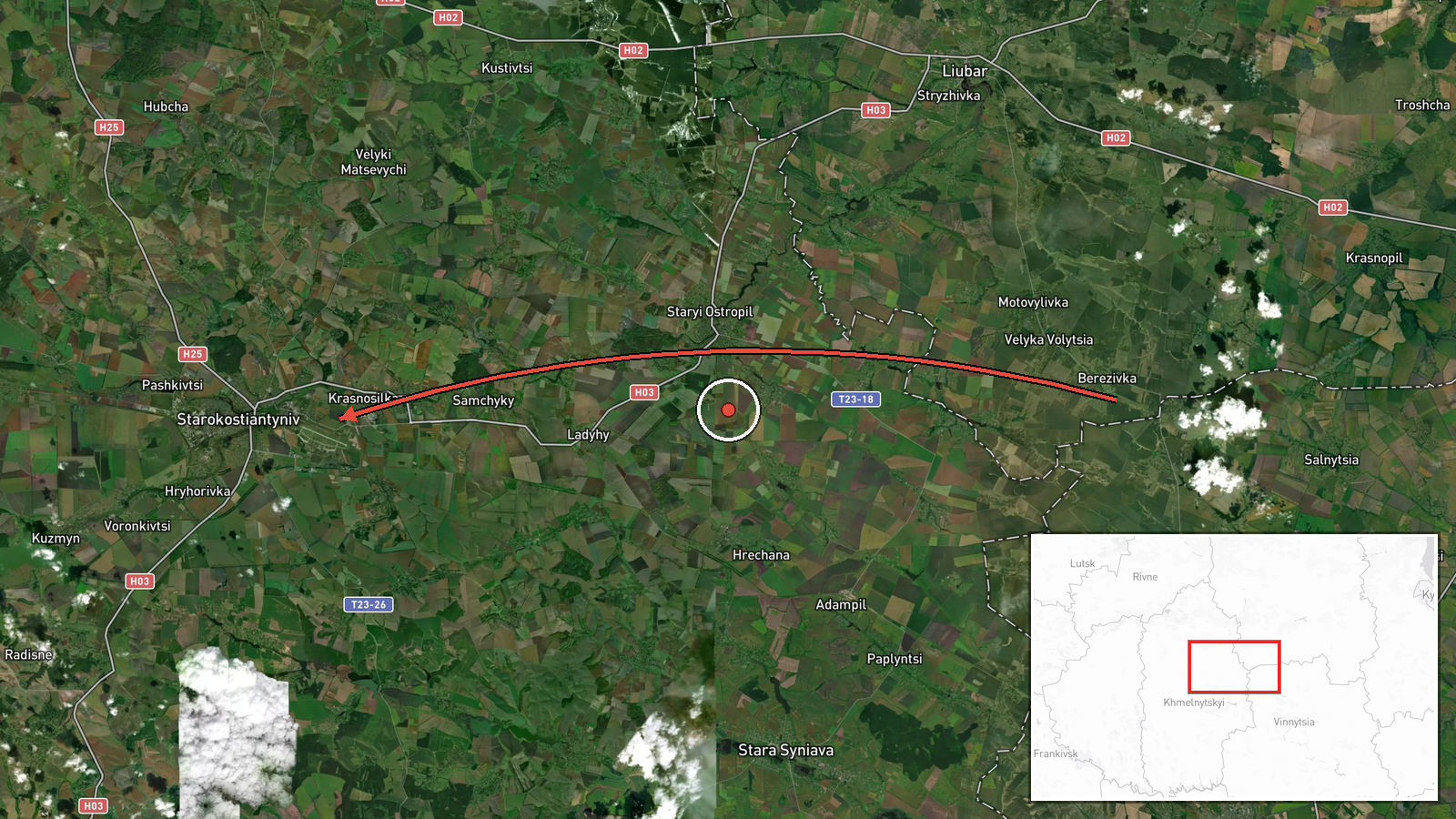
Single jet-powered Shahed (Geran-3) drone tracked from Vinnytsia Oblast toward Starokostyantyniv, Khmelnytskyi Oblast
What happened
Ukrainian air monitoring reported one Russian jet-powered Shahed (Geran-3) drone moving from the north of Vinnytsia Oblast on a course toward Starokostyantyniv in Khmelnytskyi Oblast, western Ukraine, at about 14:45 UTC on 19 October 2026. The information came from the Telegram channel @kpszsu, the account associated with the Ukrainian Air Force's monitoring messages. The original post was worded as a jet-type UAV on the northern Vinnytsia route heading for Khmelnytskyi, with Starokostyantyniv named as the direction of travel. The report describes a transit, not a confirmed strike, and it does not state any impact, damage or casualties.
Context and assessment
Starokostyantyniv sits in western Ukraine, well behind the front line, and the sequence of reports that day shows a corridor of drone movement crossing Khmelnytskyi Oblast. Earlier reports the same day describe two or more Geran-3 drones moving from Vinnytsia Oblast toward Khmelnytskyi Oblast at 07:57 UTC, a single drone over Khmelnytskyi city at 14:01, and another drone heading toward Khmelnytskyi at the same time. A Banderol mini cruise missile was also tracked toward the oblast the evening before. The pattern suggests that the region is being used as a transit route for long-range strike packages aimed at targets farther west or north, rather than as a single isolated target. Tracks like this one are typically reported as the drones are being followed by air defence and monitoring units, so the report most likely reflects an in-flight track rather than the final point of attack. Operationally, repeated single-drone tracks through the same oblasts may indicate probing, decoy use, or attempts to stretch air defence coverage across several regions at once.
Sources and confidence
The report rests on one channel, Telegram @kpszsu, with no independent cross-confirmation in the provided data. The confidence score of 8.0 reflects the official-style origin of the account and the specific, consistent wording of the track, but it is held below the maximum because the post is a single-source, in-flight notification and no later report of impact, interception or a ground outcome is available. Confidence would rise with corroboration from a second monitoring channel, regional military administration statements, or confirmed interception records. It would fall if the track was later revised, reclassified, or contradicted by other air monitoring.
Location
The coordinates correspond to the settlement of Starokostyantyniv, a town in Khmelnytskyi Oblast, which was assigned at settlement precision with high location confidence. The report names the settlement as the direction of flight rather than a specific facility, so the point marks the town rather than any installation within it. The town lies in the Podolia region of western Ukraine, on the Horyn river, a setting of rolling farmland and river valleys. The location is far from the front line and near the Vinnytsia and Khmelnytskyi oblast boundary, which explains its place on the transit route.
Related events nearby
- Ukrainian air monitoring: 1 Russian jet-powered Shahed (Geran-3) drone heading toward Khmelnytskyi.2026-10-19 14:01 UTC · Drone Transit · Khmelnytskyi, Ukraine
- Ukrainian air monitoring: 1 Russian jet-powered Shahed (Geran-3) drone over Khmelnytskyi.2026-10-19 14:01 UTC · Drone Transit · Khmelnytskyi, Ukraine
- Ukrainian air monitoring: 2+ Russian jet-powered Shahed (Geran-3) drones from Vinnytsia Oblast toward Khmelnyt2026-10-19 07:57 UTC · Drone Transit · Khmelnytskyi Oblast, Ukraine
- Ukrainian air monitoring: 1 Russian Banderol mini cruise missile heading toward Khmelnytskyi Oblast.2026-10-18 19:33 UTC · Cruise Missile · Khmelnytskyi Oblast, Ukraine
- Ukrainian air monitoring: 1 Russian jet-powered Shahed (Geran-3) drone from Zhytomyr Oblast toward Liubar.2026-10-19 14:00 UTC · Drone Transit · Liubar, Ukraine
▶ View this event on the live map

Intel Mapper aggregates open-source reports from monitored Telegram and X channels, geolocates them, cross-checks duplicates across sources and assigns a confidence score. Entries are updated as new confirmations arrive. Read how we verify events.