Ukrainian air monitoring reports one Geran-3 jet drone moving from Poltava toward Cherkasy Oblast
What happened
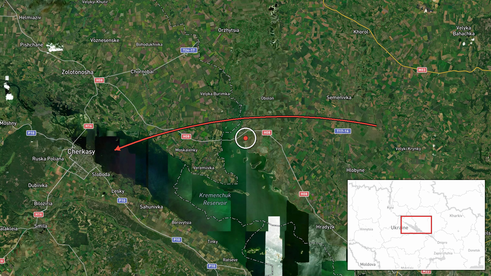
Ukraine's Air Force monitoring channel on Telegram (@kpszsu) reported at 16:00 UTC on 19 October 2026 that one jet-powered Shahed-type drone, identified as a Geran-3, was passing near Orzhytsia in Poltava Oblast and heading into Cherkasy Oblast. The original Ukrainian wording describes a jet-powered drone flying past Orzhytsia in Poltava and moving on toward Cherkasy. The report gives no precise track, altitude, or speed, and it does not say whether the drone was intercepted, crashed, or struck anything. It is classified as a drone transit rather than a strike, and no casualties, damage, or targets are mentioned. Russia is listed as the actor, which matches the platform type and the standard attribution used in Ukrainian monitoring reports.
Context and assessment
Cherkasy Oblast sits on the Dnipro in central Ukraine, and its road, rail and industrial links make it a corridor that Russian long-range drones and missiles have repeatedly crossed on routes toward western and northwestern regions. The related events show a sustained pattern over roughly 36 hours. On 18 October, single Banderol mini cruise missiles were tracked over Zolotonosha district and past Myrhorod, heading toward Cherkasy, and on 19 October morning monitoring logged two or more Geran-3 drones moving west through the oblast. This event is the latest in that sequence and follows the same path from Poltava through Cherkasy. Taken together, the reports suggest a repeated flight corridor across central Ukraine rather than a single isolated launch. The low count of one drone in this report does not show the full size of the activity. Operationally, a mix of cruise missiles and jet-powered drones on overlapping routes may be intended to stretch air defence coverage, or it may reflect routing around sites in the region. Monitoring of this kind is more often used to warn of possible targets than to confirm them, so the reports do not establish intent.
Sources and confidence
The only source is the Telegram channel @kpszsu, which is widely associated with Ukraine's Air Force. No second outlet, official statement, or independent tracking report is cited for this specific drone. The confidence score of 8.0 reflects a credible official-style source with a clear, time-stamped description, but it is held back because the report is single-channel and gives no track detail. Confidence would rise if other monitoring channels or the Air Force's public updates confirm the same drone's path, or if imagery or debris reports tie it to the area. It would fall if later corrections or conflicting monitoring reports show a different route or a different aircraft type.
Location
The location is recorded at the regional level for Cherkasy Oblast, with a low location confidence. The coordinates (49.44, 32.06) are a regional reference point near the city of Cherkasy and do not mark the drone's position. The drone is reported moving from Orzhytsia in Poltava Oblast toward Cherkasy Oblast, so the exact point of the report is not known. The area is largely flat farmland and forest-steppe, with the Dnipro River and its reservoir system running through the oblast.
Related events nearby
- Ukrainian air monitoring: 1 Russian jet-powered Shahed (Geran-3) drone passing Cherkasy Oblast, heading northw2026-10-19 15:54 UTC · Drone Transit · Cherkasy Oblast, Ukraine
- Ukrainian air monitoring: 2+ Russian jet-powered Shahed (Geran-3) drones passing Cherkasy Oblast, heading west2026-10-19 07:26 UTC · Drone Transit · Cherkasy Oblast, Ukraine
- Ukrainian air monitoring: 1 Russian Banderol mini cruise missile passing Myrhorod, heading toward Cherkasy Obl2026-10-18 19:37 UTC · Cruise Missile · Cherkasy Oblast, Ukraine
- Ukrainian air monitoring: 1 Russian Banderol mini cruise missile passing Myrhorod, heading toward Zolotonosha 2026-10-18 19:19 UTC · Cruise Missile · Zolotonosha district, Ukraine
- Ukrainian air monitoring: 1 Russian Banderol mini cruise missile over Zolotonosha district.2026-10-18 18:48 UTC · Cruise Missile · Zolotonosha district, Ukraine
▶ View this event on the live map

Intel Mapper aggregates open-source reports from monitored Telegram and X channels, geolocates them, cross-checks duplicates across sources and assigns a confidence score. Entries are updated as new confirmations arrive. Read how we verify events.