Jet-powered Shahed drones reported moving west through Rivne Oblast, Ukrainian monitoring says
What happened
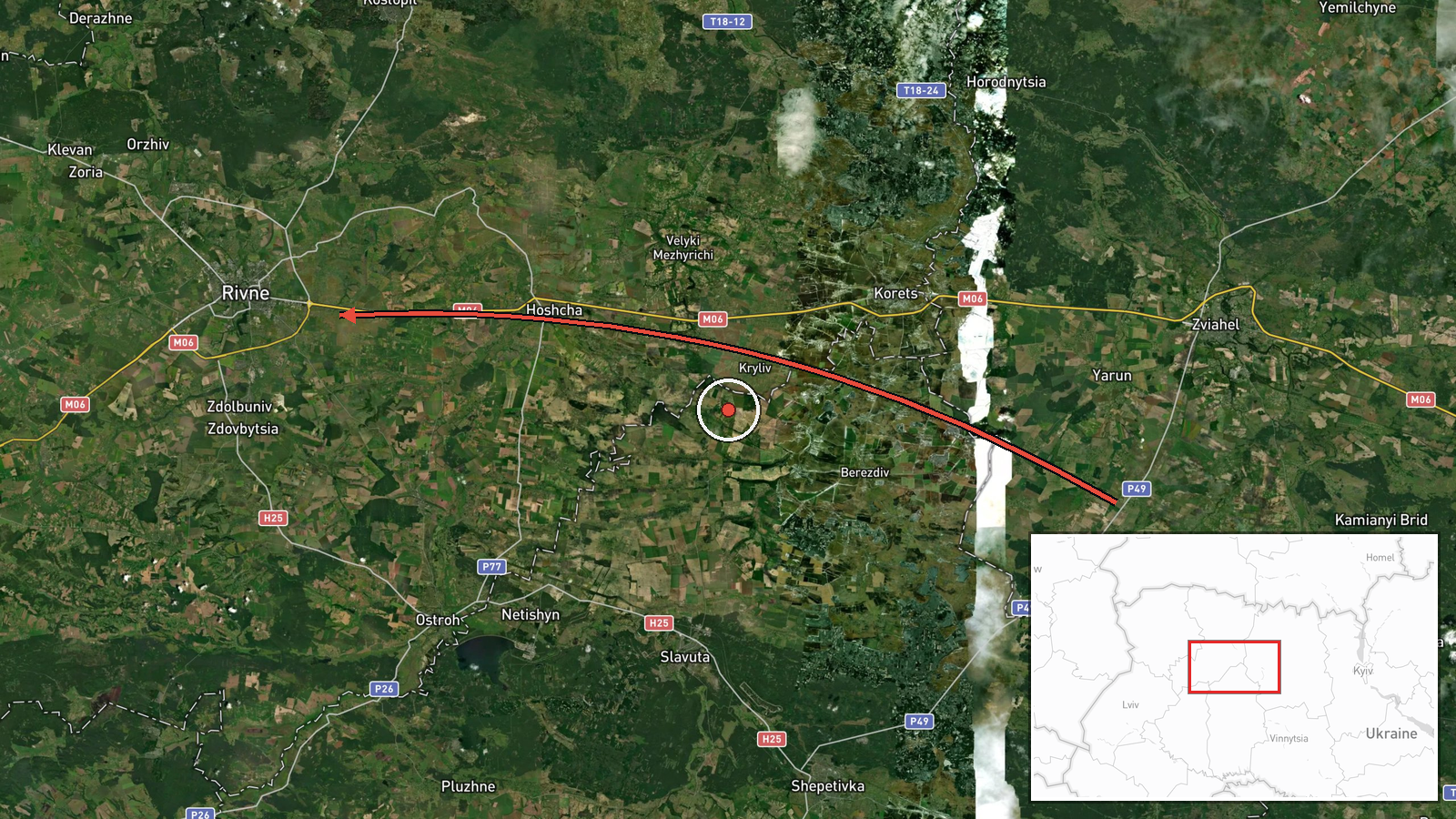
Ukrainian air monitoring reported on 19 October 2026 at 21:38 UTC that jet-powered drones, identified in the summary as Russian Shahed (Geran-3) types, were moving from Zhytomyr Oblast toward Rivne Oblast, with a second movement from Rivne Oblast toward Volyn on a westward course. The Telegram channel @kpszsu, the public feed used for Ukrainian Air Force air-alert messages, carried the original Ukrainian text, which refers to jet drones (реактивні БпЛА) without giving a precise count in that line. The related entries describe two or more drones passing Olevsk, a settlement in northern Zhytomyr Oblast, and a series of single-drone alerts earlier the same afternoon and evening. The report describes transit only; no impacts, casualties, or damage are mentioned.
Context and assessment
Rivne Oblast lies in northwestern Ukraine, in the Polissia lowlands, and its regional centre, Rivne city, sits on the main east-west axis linking the northern part of the country with Volyn and the western regions. Drone transit alerts in this area are common when long-range Shahed-type systems are routed through the north toward western Ukraine, and the sequence here fits that pattern. Between 16:36 and 21:38 UTC the reports show a rising count, moving from single drones to groups of two or more, and a consistent westward heading across several oblasts. Jet-powered Geran-3 variants are widely described as faster than the older propeller-driven models, which could make interception windows shorter. The pattern may indicate a route through the north toward western targets, or it may reflect drones being repositioned or testing corridors. Transit alerts alone do not establish which targets, if any, were intended, so any operational reading should remain provisional.
Sources and confidence
The event rests on a single Telegram channel, @kpszsu, and the data includes no independent cross-confirmation from other official Ukrainian channels, regional military administrations, or media outlets. The confidence score of 8.0 reflects that single-source basis, the transit-only nature of the report, and the region-level location. Confidence would rise with corroboration from additional Ukrainian official sources, regional administration statements, or independent flight-tracking or radar-based reporting that confirms the number and path of drones. It would fall if the alerts were revised, withdrawn, or contradicted by later official information. The record is not marked as corrected.
Location
The location is assigned at region level as Rivne Oblast, Ukraine, and no specific settlement was identified for this entry. The listed coordinates of 50.62 N, 26.25 E approximately match Rivne city, the oblast centre, so they should be read as an approximate placement rather than a confirmed point. The setting is northwestern Ukraine, with forests, wetlands, and farmland typical of Polissia, Zhytomyr Oblast to the east, Volyn to the west, and the Belarus border region to the north.
Related events nearby
- Ukrainian air monitoring: 2+ Russian jet-powered Shahed (Geran-3) drones from northern Zhytomyr Oblast toward 2026-10-19 21:27 UTC · Drone Transit · Rivne Oblast, Ukraine
- Ukrainian air monitoring: 1 Russian jet-powered Shahed (Geran-3) drone heading toward Rivne Oblast.2026-10-19 19:54 UTC · Drone Transit · Rivne Oblast, Ukraine
- Ukrainian air monitoring: 1 Russian jet-powered Shahed (Geran-3) drone heading toward Rivne.2026-10-19 17:53 UTC · Drone Transit · Rivne, Ukraine
- Ukrainian air monitoring: 2+ Russian jet-powered Shahed (Geran-3) drones passing Olevsk, heading toward Rivne 2026-10-19 17:35 UTC · Drone Transit · Rivne Oblast, Ukraine
- Ukrainian air monitoring: 1 Russian jet-powered Shahed (Geran-3) drone passing Rivne Oblast, heading west.2026-10-19 16:36 UTC · Drone Transit · Rivne Oblast, Ukraine
▶ View this event on the live map

Intel Mapper aggregates open-source reports from monitored Telegram and X channels, geolocates them, cross-checks duplicates across sources and assigns a confidence score. Entries are updated as new confirmations arrive. Read how we verify events.