Jet-powered Shahed drones reportedly cross northern Chernihiv Oblast from Kyiv Oblast
What happened
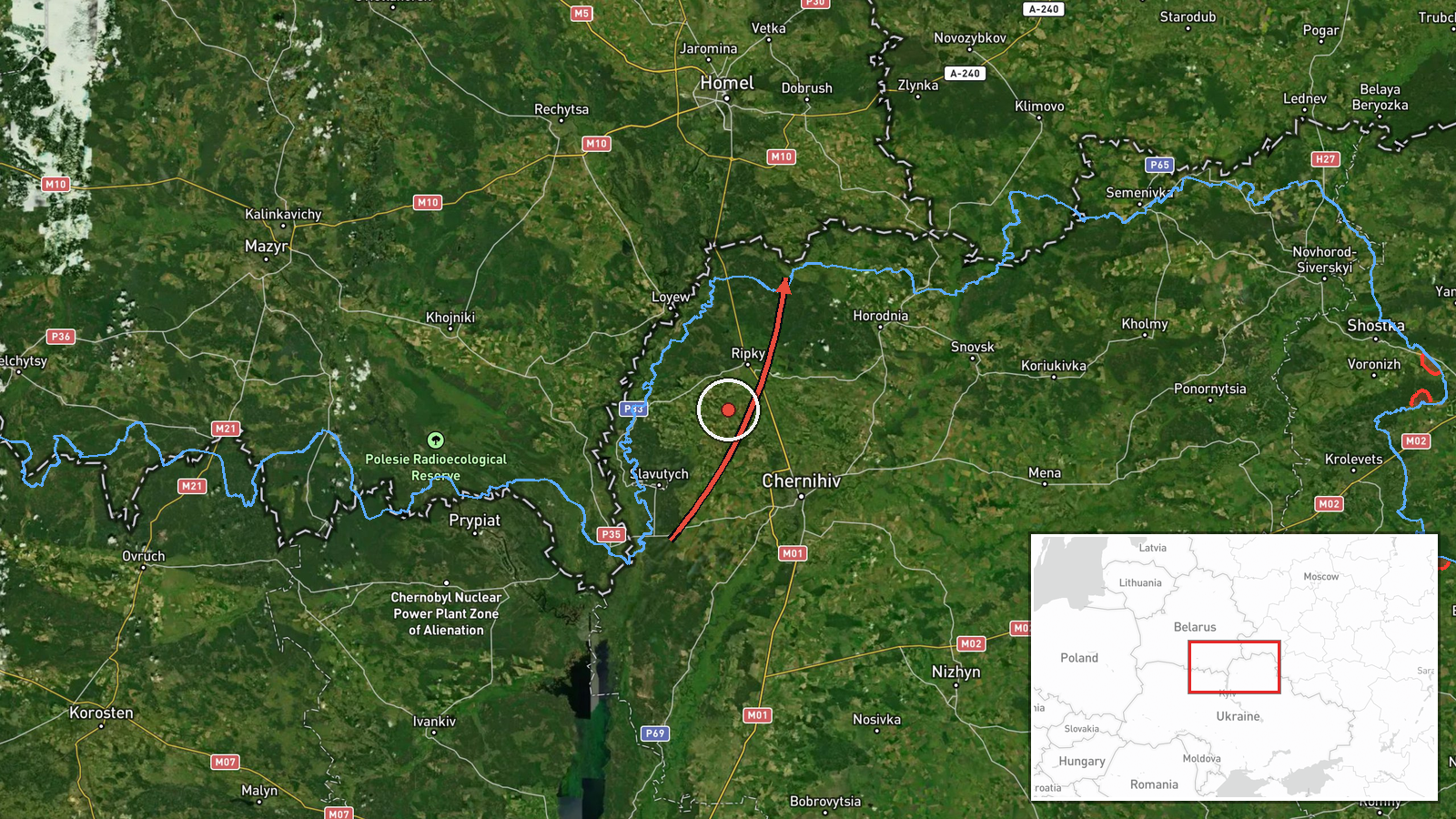
Ukrainian air monitoring, relayed through the Telegram channel @kpszsu, reported at 00:14 UTC on 20 October 2026 that at least two Russian jet-powered Shahed-type drones, identified in the post as Geran-3, were moving from northern Kyiv Oblast toward northern Chernihiv Oblast. The original Ukrainian wording reads 'Реактивні БпЛА з півночі Київщини на північ Чернігівщини', describing the drones as jet-powered and giving only a directional route. The post does not name a target, impact point, or damage. The event is classified as a drone transit, meaning the aircraft were tracked in flight. Because it is a single-channel monitoring update, it records what was observed at posting time rather than a verified outcome.
Context and assessment
Northern Chernihiv Oblast sits along the Belarusian border and near the Bryansk region of Russia, so drones routed through it can be tracking toward Chernihiv city, toward western or central Ukraine, or simply transiting. This report is the latest in a dense run of related alerts on 19 and 20 October. Earlier posts describe drones entering from Bryansk, one from Sumy Oblast, others passing western Chernihiv Oblast and heading south, and groups of two or more heading toward Chernihiv city and onward through Nova. Taken together, the pattern suggests repeated overflights of the same northern corridor over roughly a day rather than a single isolated launch. Operationally, the jet-powered Geran-3 variant is generally understood to be faster than the older propeller-driven models, which may complicate interception and shorten warning windows. It may also indicate attempts to saturate air defenses across several axes. These are inferences from the pattern, not confirmed intentions.
Sources and confidence
The event rests on one Telegram channel, @kpszsu, which is widely associated with Ukraine's Air Force monitoring updates. No independent outlet, second channel, or official statement in the event data confirms the drone count or route. The confidence score of 8.0 reflects a credible, official-leaning primary source with consistent related reporting, but it is held below the top range because the detail comes from a single post and the destination is not stated. Confidence would rise with corroboration from Ukrainian official statements, regional authority alerts, or Chernihiv-area reports of sightings or impacts. It would fall if later updates revise the drone count, correct the route, or show the aircraft turned back or were not Shahed-type.
Location
The coordinates are a broad regional point in northern Chernihiv Oblast, not a settlement, facility, or precise flight-track position, and location confidence is recorded as low. The area is largely flat, forested, and agricultural, with the Desna and Dnipro river basins to the east and the Belarusian frontier to the north. Coordinates should be read as approximate for the oblast's northern half.
Related events nearby
- Ukrainian air monitoring: 2+ Russian jet-powered Shahed (Geran-3) drones from Bryansk (Russia) toward northern2026-10-19 16:17 UTC · Drone Transit · northern Chernihiv Oblast, Ukraine
- Ukrainian air monitoring: 3+ Russian jet-powered Shahed (Geran-3) drones passing Nova, heading toward Chernihi2026-10-19 23:44 UTC · Drone Transit · Chernihiv Oblast, Ukraine
- Ukrainian air monitoring: 2+ Russian jet-powered Shahed (Geran-3) drones heading toward Chernihiv.2026-10-19 21:01 UTC · Drone Transit · Chernihiv, Ukraine
- Ukrainian air monitoring: 1 Russian Shahed-type drone from Sumy Oblast toward Chernihiv Oblast.2026-10-19 02:44 UTC · Drone Transit · Chernihiv Oblast, Ukraine
- Ukrainian air monitoring: 2+ Russian jet-powered Shahed (Geran-3) drones passing Belarus, heading west.2026-10-20 01:02 UTC · Drone Transit · Belarus
▶ View this event on the live map

Intel Mapper aggregates open-source reports from monitored Telegram and X channels, geolocates them, cross-checks duplicates across sources and assigns a confidence score. Entries are updated as new confirmations arrive. Read how we verify events.