Jet-powered Shahed-type drones reported moving from Bryansk toward northern Chernihiv Oblast
What happened
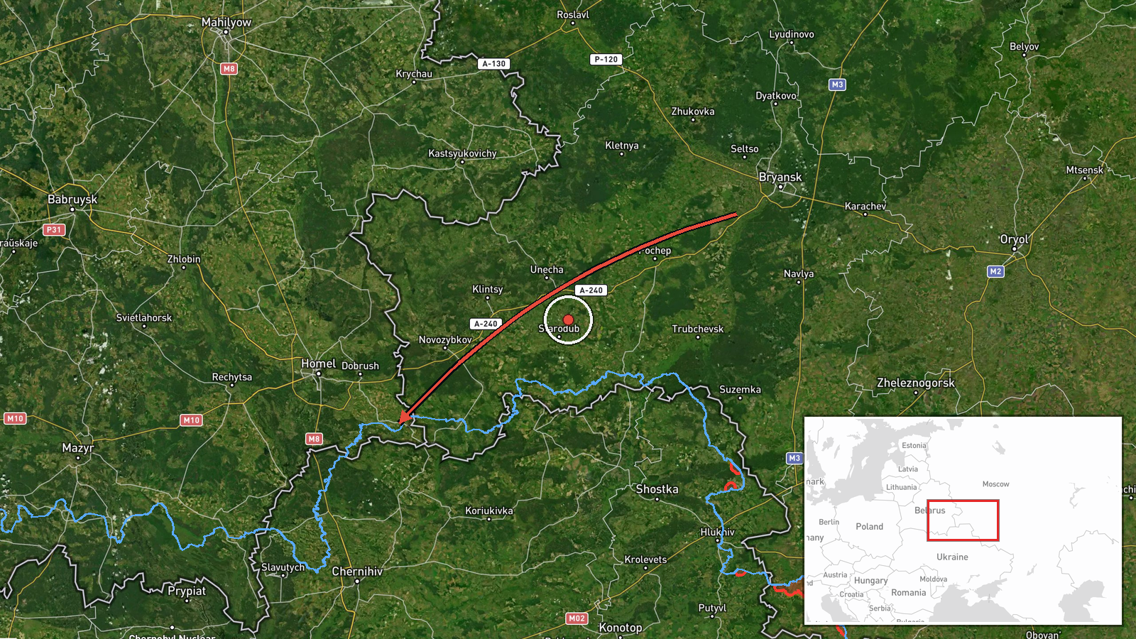
Ukraine's air monitoring channel on Telegram, @kpszsu, reported at 16:17 UTC on 19 October 2026 that two or more jet-powered drones were flying from Bryansk Oblast in Russia toward northern Chernihiv Oblast in Ukraine. The original Ukrainian post uses the phrase 'Реактивні БпЛА' (jet-powered unmanned aerial vehicles) and an arrow showing direction of travel. The summary identifies the drones as Russian Shahed-type models, specifically Geran-3, which is the jet-powered variant. The post gives only a broad area, northern Chernihiv region, and names no settlement. It does not describe any impact, damage, casualties, or interception. The report is a single-channel air alert and is recorded as stated, pending confirmation from other sources.
Context and assessment
Chernihiv Oblast sits on Ukraine's northern border, next to Belarus and Russia's Bryansk and Sumy regions, so routes that cross it from Bryansk are a recurring feature of the air war in the north. The related entries on the same day show a dense pattern of transits. Earlier, a single Shahed-type drone was reported moving from Sumy Oblast toward Chernihiv Oblast, and two or more jet-powered Geran-3 drones were reported passing western Chernihiv Oblast heading south. Later alerts describe a cruise missile crossing eastern Chernihiv heading west, another moving toward Kozelets, and additional drones passing western Chernihiv heading south, one of them from southern Kirovohrad Oblast. Taken together, these reports suggest multiple launch axes and routes that cut across the oblast from several directions. Such activity may be intended to stretch air defence coverage across the north, to hit targets further south or west, or both. Transit reports on their own do not show the intended target, and the related events are a pattern signal rather than confirmation of a strike plan.
Sources and confidence
The report rests on one Telegram channel, @kpszsu, which is the official Ukrainian Air Force channel that publishes air alerts and monitoring updates. No second outlet, official statement, or independent tracking source is linked to this entry, so cross-confirmation is absent. The confidence score of 8.0 is low on the platform's scale, which reflects a single source, a general area rather than a specific location, and no verified outcome. Confidence would rise if other monitoring channels or regional authorities confirmed the same track, or if subsequent reports named a settlement or described an impact. It would fall if later reporting contradicted the route or showed that the drones were diverted elsewhere.
Location
The location is recorded at the regional level as northern Chernihiv Oblast, with approximate coordinates near 52.08 north and 31.29 east. This is not a settlement or facility, and the precision is marked as low. The area lies close to the Belarus border and is north of the oblast's main city of Chernihiv. It is largely flat, wooded and farmland terrain, with rivers such as the Desna and its tributaries crossing the broader region. Bryansk Oblast borders this part of Chernihiv to the northeast.
Related events nearby
- Ukrainian air monitoring: 1 Russian Shahed-type drone from Sumy Oblast toward Chernihiv Oblast.2026-10-19 02:44 UTC · Drone Transit · Chernihiv Oblast, Ukraine
- Ukrainian air monitoring: 1 Russian Shahed-type drone passing western Chernihiv Oblast, heading south; 1 Russi2026-10-19 03:57 UTC · Drone Transit · western Chernihiv Oblast, Ukraine
- Ukrainian air monitoring: 1 Russian cruise missile passing eastern Chernihiv Oblast, heading west.2026-10-19 03:38 UTC · Cruise Missile · eastern Chernihiv Oblast, Ukraine
- Ukrainian air monitoring: 2+ Russian jet-powered Shahed (Geran-3) drones passing western Chernihiv Oblast, hea2026-10-19 02:44 UTC · Drone Transit · western Chernihiv Oblast, Ukraine
- Ukrainian air monitoring: 1 Russian cruise missile heading toward Kozelets.2026-10-19 03:43 UTC · Cruise Missile · Kozelets, Ukraine
▶ View this event on the live map

Intel Mapper aggregates open-source reports from monitored Telegram and X channels, geolocates them, cross-checks duplicates across sources and assigns a confidence score. Entries are updated as new confirmations arrive. Read how we verify events.