Two or more Russian Geran-3 drones reported moving toward Slavutych from northern Chernihiv Oblast
What happened
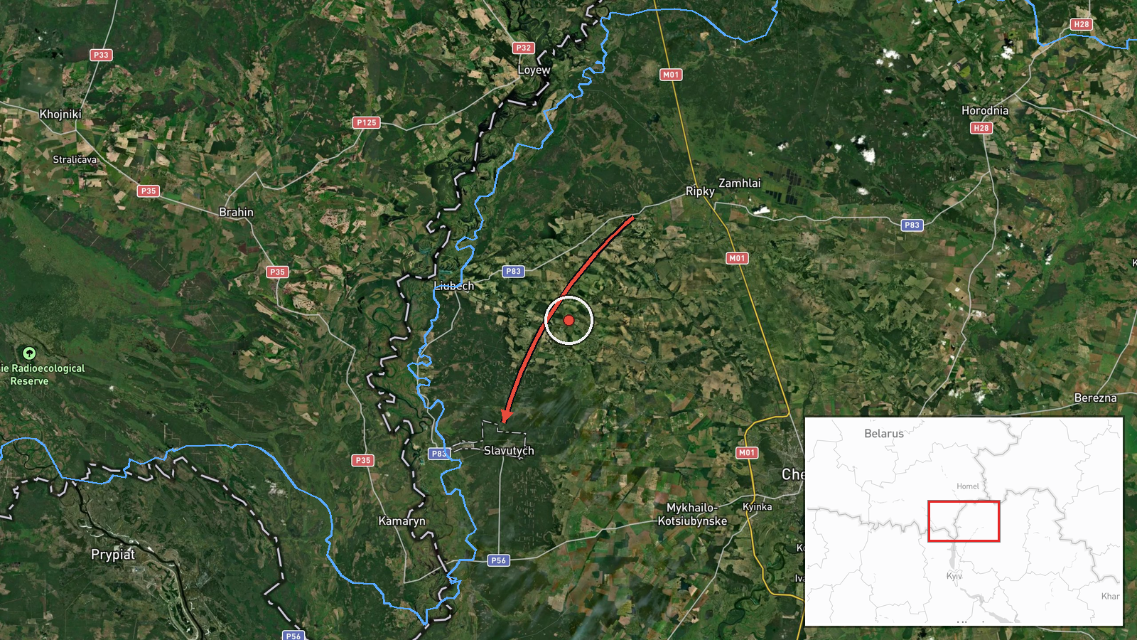
Ukraine's Air Force, through its official Telegram channel @kpszsu, reported at about 07:29 UTC on 20 October 2026 that two or more Russian jet-powered Shahed (Geran-3) drones were moving from northern Chernihiv Oblast toward Slavutych, a city in northern Ukraine. The original Ukrainian-language post described jet-type unmanned aircraft over northern Chernihiv Oblast on a course for Slavutych. The wording is a monitoring notice, not a report of impact. It does not describe any strike, damage, or casualties, and the '2+' figure indicates a minimum count rather than a confirmed total. The event is logged as a drone transit, with Russia named as the actor.
Context and assessment
Slavutych matters less as a stated target than as a point on a route. The related events show a sustained drone track across the region. Between 19:44 UTC on 19 October and early on 20 October, Ukrainian monitoring logged groups of Geran-3 drones passing Nova and heading toward Chernihiv, then Chernihiv itself, then moving from northern Chernihiv Oblast into northern Kyiv Oblast, with later reports describing movement heading south. The pattern suggests formations entering from the north, using the Chernihiv and Kyiv border area as a corridor, and turning or dispersing as they move south. Groups of two or three aircraft recurring over several hours may indicate successive waves or repeated sorties rather than a single launch. Because Slavutych sits near the Chernobyl exclusion zone and the Belarus border, its inclusion in the report may also reflect its position as a navigation reference point in the northern approach. These are inferences from the reporting pattern, not confirmed intent, and the reports do not establish which final targets, if any, the drones were aimed at.
Sources and confidence
The report rests on a single Telegram channel, @kpszsu, which is the official channel of the Ukrainian Air Force and is widely used for real-time air alerts. The confidence score of 8.0 reflects that institutional authority and the consistency of the wider drone-transit series, but it is not a cross-confirmed score. No independent outlet, satellite imagery, or second monitoring source appears in the data for this specific post. Confidence would rise if an independent source or official follow-up confirmed the track or reported an impact, and it would fall if later official updates changed the number of aircraft or the direction of travel.
Location
The location is a settlement-level match. Slavutych is a city in Chernihiv Oblast, placed at its town coordinates, and the report names it directly, so the point marks the city rather than a specific facility. The setting is northern Ukraine, close to the Belarus border and the Chernobyl exclusion zone, on relatively flat terrain with forest and river valleys typical of the Polissia lowlands. The point does not indicate the drones' exact path, only the stated destination.
Related events nearby
- Ukrainian air monitoring: 3+ Russian jet-powered Shahed (Geran-3) drones passing Nova, heading toward Chernihi2026-10-19 23:44 UTC · Drone Transit · Chernihiv Oblast, Ukraine
- Ukrainian air monitoring: 2+ Russian jet-powered Shahed (Geran-3) drones heading toward Chernihiv.2026-10-19 21:01 UTC · Drone Transit · Chernihiv, Ukraine
- Ukrainian air monitoring: 2+ Russian jet-powered Shahed (Geran-3) drones passing northern Kyiv Oblast, heading2026-10-20 07:04 UTC · Drone Transit · northern Kyiv Oblast, Ukraine
- Ukrainian air monitoring: 1 Russian jet-powered Shahed (Geran-3) drone from northern Chernihiv Oblast toward n2026-10-20 03:25 UTC · Drone Transit · northern Kyiv Oblast, Ukraine
- Ukrainian air monitoring: 2+ Russian jet-powered Shahed (Geran-3) drones from northern Chernihiv Oblast toward2026-10-20 02:38 UTC · Drone Transit · northern Kyiv Oblast, Ukraine
▶ View this event on the live map

Intel Mapper aggregates open-source reports from monitored Telegram and X channels, geolocates them, cross-checks duplicates across sources and assigns a confidence score. Entries are updated as new confirmations arrive. Read how we verify events.