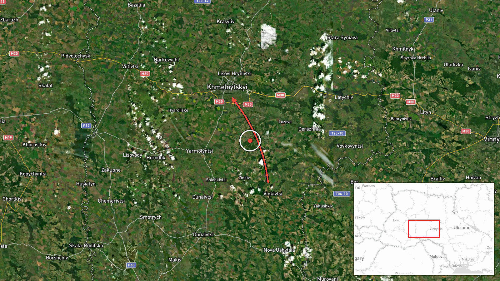
Single Russian Shahed-type drone reported passing Vinkivtsi toward Khmelnytskyi, Ukraine
What happened
Ukrainian air monitoring, relayed through the Telegram channel @kpszsu, reported at 03:02 UTC on 20 October 2026 that one Russian Shahed-type drone was passing Vinkivtsi and heading toward Khmelnytskyi. The original Ukrainian post reads 'Повз Віньківці ➡️ у напрямку Хмельницького', which describes a transit along a route rather than a strike or impact. The post does not state the drone's altitude, speed, type variant, or whether it was later intercepted or tracked to a target. It reports no casualties, damage, or outcome. The event is logged as a single-channel report classed as a drone transit, and it forms part of a series of similar air-monitoring alerts issued across Khmelnytskyi Oblast in the preceding three hours.
Context and assessment
Khmelnytskyi is a regional centre in western Ukraine, and the oblast has appeared repeatedly in air-monitoring alerts in the hours before this report. Between 00:05 and 02:55 UTC on the same day, five related transit reports described one to two or more drones moving through or toward Khmelnytskyi and Khmelnytskyi Oblast. Several of those reports specify jet-powered Geran-3 variants, and one describes a drone travelling from Zhytomyr Oblast, which suggests a sustained flow crossing northern and central western Ukraine rather than an isolated incursion. The pattern of repeated waypoints, including Murovani Kurylivtsi and Derazhnya, indicates that operators are moving drones along a corridor over several hours. Operationally, this may reflect a deliberate sequence of long-range launches, decoys or saturation aimed at stretching air defence and radar coverage, though transit alerts alone do not establish intent or target selection. Because the data contains no confirmed impact, the most defensible reading is that the cluster shows persistent activity in the region, with the purpose of individual drones remaining unverified.
Sources and confidence
The report rests on one Telegram channel, @kpszsu, which the data identifies as Ukrainian air monitoring, and no independent outlet has been recorded as confirming it. That single-source status, combined with the absence of any named impact, explains the confidence score of 8.0, which is high for a transit report but reflects the lack of cross-confirmation. The location is marked as high confidence, but the source is a short monitoring update rather than a verified track. Confidence would rise if a second Ukrainian or independent monitoring source corroborated the track, if official air force statements gave a route or time confirmation, or if the drone was later reported as intercepted or striking a site. It would fall if the track were revised, the channel corrected the post, or no further reports matched the trajectory.
Location
The event is geolocated to Khmelnytskyi city at coordinates 49.42 N, 26.98 E, at settlement precision, which marks the drone's stated destination rather than its exact position over Vinkivtsi. Vinkivtsi is named as a waypoint and is not separately geolocated in the data. The area lies in Podillia, a region of rolling upland in western Ukraine, and the city is among the larger population centres in that part of the country. The Khmelnytskyi nuclear power plant is located in the wider area near Netishyn, a notable regional feature.
Related events nearby
- Ukrainian air monitoring: 1 Russian jet-powered Shahed (Geran-3) drone passing Brayiliv, heading toward Khmeln2026-10-20 03:35 UTC · Drone Transit · Khmelnytskyi Oblast, Ukraine
- Ukrainian air monitoring: 2+ Russian jet-powered Shahed (Geran-3) drones passing Murovani Kurylivtsi, heading 2026-10-20 02:55 UTC · Drone Transit · Khmelnytskyi Oblast, Ukraine
- Ukrainian air monitoring: 1 Russian jet-powered Shahed (Geran-3) drone passing Derazhnya, heading toward Khmel2026-10-20 02:19 UTC · Drone Transit · Khmelnytskyi, Ukraine
- Ukrainian air monitoring: 1 Russian jet-powered Shahed (Geran-3) drone from Zhytomyr Oblast toward Khmelnytsky2026-10-20 01:45 UTC · Drone Transit · Khmelnytskyi Oblast, Ukraine
- Ukrainian air monitoring: 1 Russian jet-powered Shahed (Geran-3) drone heading toward Khmelnytskyi.2026-10-20 00:21 UTC · Drone Transit · Khmelnytskyi, Ukraine
▶ View this event on the live map

Intel Mapper aggregates open-source reports from monitored Telegram and X channels, geolocates them, cross-checks duplicates across sources and assigns a confidence score. Entries are updated as new confirmations arrive. Read how we verify events.