Ukrainian Air Force reports one jet-powered Shahed drone passing Derazhnya toward Khmelnytskyi
What happened
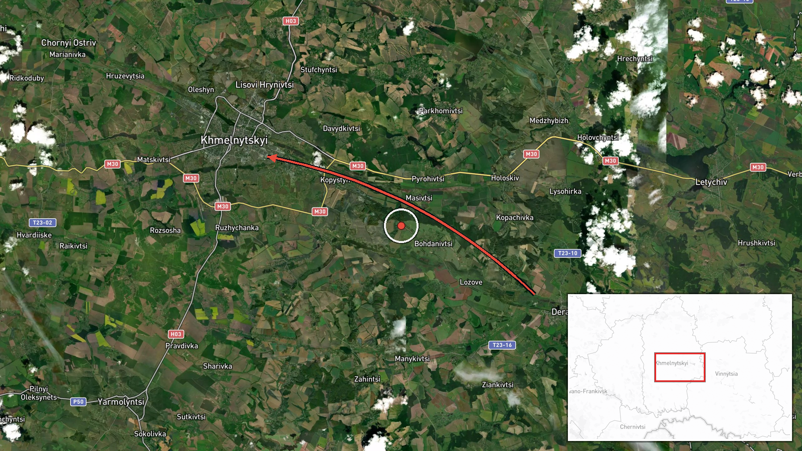
Ukraine's Air Force monitoring channel on Telegram, @kpszsu, reported at 02:19 UTC on 20 October 2026 that one jet-powered Shahed-type drone, identified as the Geran-3, was passing Derazhnya and heading toward Khmelnytskyi. The original Ukrainian wording describes a 'reactive UAV' passing Derazhnya in the direction of Khmelnytskyi, the standard format in which the monitoring service flags a track and its heading. The post reports transit only and does not describe any strike, detonation or damage. The event is recorded as a drone transit in Khmelnytskyi, Ukraine, with Russia listed as the actor on the basis of the Shahed-series attribution in the report.
Context and assessment
This report is one of five drone-transit entries in the Khmelnytskyi area logged between 14:01 UTC on 19 October and 01:45 UTC on 20 October 2026. The earlier entries describe single drones heading toward Khmelnytskyi, and groups of two or more passing from southern Vinnytsia Oblast and over Murovani Kurylivtsi. The 01:45 entry tracks a drone moving from Zhytomyr Oblast toward Khmelnytskyi Oblast, which suggests a track that crossed the region from the north before this later report. The pattern of repeated tracks along a similar northwest to southwest corridor over roughly twelve hours may indicate drones routed through western Ukraine, either toward targets further west or as part of a broader night launch. The data alone cannot identify the intended target. The jet-powered Geran-3 variant is generally described as faster than piston-engine Shaheds, which would shorten the warning window for communities along the route, though that is a general characteristic rather than a measured value for this flight.
Sources and confidence
The event rests on a single Telegram channel, @kpszsu, which is the official air monitoring account of Ukraine's Air Force. No independent outlet or second channel is listed for this entry, so cross-confirmation is absent. The related events come from the same type of monitoring feed and are not independent corroboration of this specific track. The confidence score of 8.0 reflects an official-origin source, consistent timing and a clearly described track, offset by the single-source basis. Confidence would rise with confirmation from wire agencies, regional authorities or a second monitoring account, and would fall if the Air Force issued a correction or a later update changed the track or heading.
Location
The coordinates, 49.42 N and 26.98 E, are set at settlement precision and matched to Khmelnytskyi city, with high location confidence. Derazhnya is a smaller settlement in the wider area, so the plotted point reflects the destination named in the report rather than the exact position of the drone when it was observed over Derazhnya. Khmelnytskyi lies in western Ukraine within the historical Podillia region, on the Southern Bug river. The terrain is largely rolling farmland with river valleys and scattered forest.
Related events nearby
- Ukrainian air monitoring: 2+ Russian jet-powered Shahed (Geran-3) drones passing Murovani Kurylivtsi, heading 2026-10-20 02:55 UTC · Drone Transit · Khmelnytskyi Oblast, Ukraine
- Ukrainian air monitoring: 1 Russian jet-powered Shahed (Geran-3) drone from Zhytomyr Oblast toward Khmelnytsky2026-10-20 01:45 UTC · Drone Transit · Khmelnytskyi Oblast, Ukraine
- Ukrainian air monitoring: 1 Russian jet-powered Shahed (Geran-3) drone heading toward Khmelnytskyi.2026-10-20 00:21 UTC · Drone Transit · Khmelnytskyi, Ukraine
- Ukrainian air monitoring: 2+ Russian jet-powered Shahed (Geran-3) drones passing Murovani Kurylivtsi, heading 2026-10-20 00:05 UTC · Drone Transit · Khmelnytskyi Oblast, Ukraine
- Ukrainian air monitoring: 2+ Russian jet-powered Shahed (Geran-3) drones from southern Vinnytsia Oblast toward2026-10-19 23:23 UTC · Drone Transit · Khmelnytskyi Oblast, Ukraine
▶ View this event on the live map

Intel Mapper aggregates open-source reports from monitored Telegram and X channels, geolocates them, cross-checks duplicates across sources and assigns a confidence score. Entries are updated as new confirmations arrive. Read how we verify events.