Jet-powered Shahed drones reported transiting Vinnytsia toward Khmelnytskyi Oblast
What happened
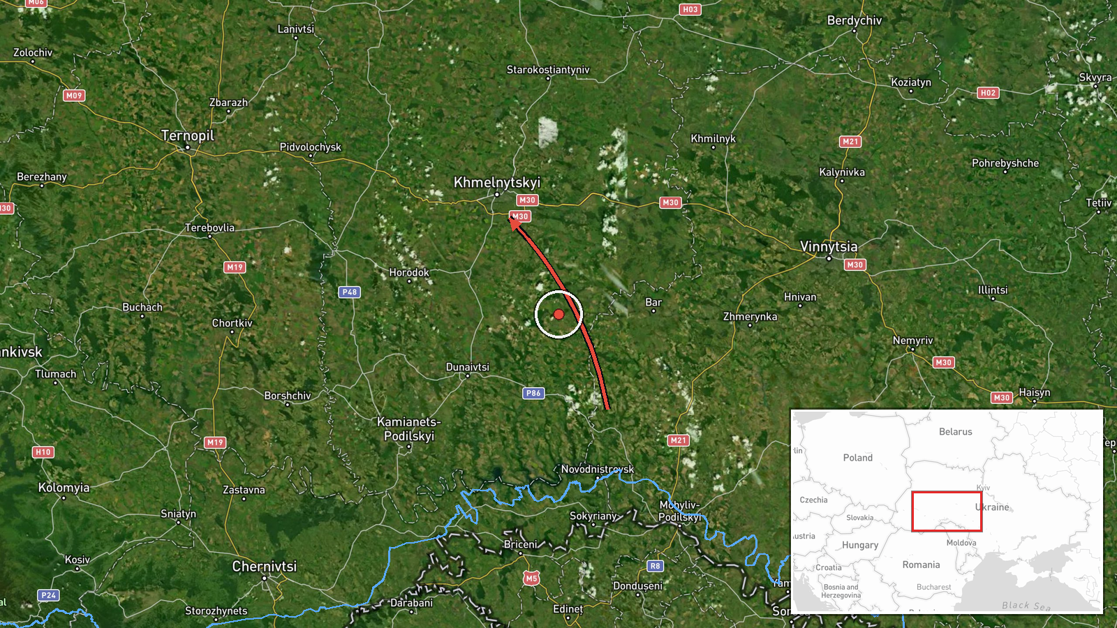
A Ukrainian air monitoring channel on Telegram (@kpszsu) reported at 00:05 UTC on 20 October 2026 that two or more Russian jet-powered Shahed (Geran-3) drones were passing Murovani Kurylivtsi and Berezivka in Vinnytsia Oblast, heading toward Khmelnytskyi Oblast. The original Ukrainian wording describes them as reactive UAVs moving in the direction of the Khmelnytskyi region, and the English summary frames the event as a transit rather than a strike. The report mentions no impact, casualties, or damage. Attribution to Russia rests on the channel's identification of the Geran-3 type, the jet-powered variant of the Shahed family. The alert is one of five other transit reports in the data, logged between 07:57 UTC on 19 October and 00:21 UTC on 20 October, all along the same corridor.
Context and assessment
Khmelnytskyi Oblast lies in western Ukraine and hosts military-industrial and logistics sites that have drawn attention in earlier phases of the war. The related reports show a consistent pattern. Between 07:57 and 23:23 UTC on 19 October, drone groups were logged moving from Vinnytsia Oblast toward Khmelnytskyi, with single drones reported over or near the city later that day and another heading toward it shortly after midnight. Repetition along one axis suggests either a sustained raid routed through central-western Ukraine or successive waves aimed at the same regional objectives, though the reports alone cannot show which targets, if any, were intended. Transit reports of this kind are typically issued as warnings to air defence units and civil authorities rather than confirmations of impact. Operationally, a path crossing Vinnytsia toward Khmelnytskyi may be an attempt to stretch air defence coverage across the region. That is an inference from the sequence, not something the data establishes.
Sources and confidence
All six entries derive from one Telegram channel, @kpszsu, which is the official channel of Ukraine's Air Force and usually the first public source for airborne threat warnings. No independent outlet or second channel in the data confirms the sightings, so the source count is one. The confidence score of 8.0 reflects the authoritative origin and consistent wording across the series, offset by the lack of cross-confirmation and the absence of a precise position. Confidence would rise with corroboration from regional military administrations, a second monitoring source, or reports of debris or interception. It would fall if updates revised or withdrew the sightings.
Location
The location is recorded only at region level. The coordinates 49.42 N, 26.98 E approximate the centre of Khmelnytskyi Oblast, so the pin does not mark a specific settlement or facility. The named waypoints Murovani Kurylivtsi and Berezivka sit in the Vinnytsia direction and were used to infer the corridor, though Berezivka is a name shared by several settlements. The oblast is mostly gently rolling Podillia upland and farmland with few natural barriers to low-flying drones.
Related events nearby
- Ukrainian air monitoring: 1 Russian jet-powered Shahed (Geran-3) drone heading toward Khmelnytskyi.2026-10-20 00:21 UTC · Drone Transit · Khmelnytskyi, Ukraine
- Ukrainian air monitoring: 2+ Russian jet-powered Shahed (Geran-3) drones from southern Vinnytsia Oblast toward2026-10-19 23:23 UTC · Drone Transit · Khmelnytskyi Oblast, Ukraine
- Ukrainian air monitoring: 1 Russian jet-powered Shahed (Geran-3) drone heading toward Khmelnytskyi.2026-10-19 14:01 UTC · Drone Transit · Khmelnytskyi, Ukraine
- Ukrainian air monitoring: 1 Russian jet-powered Shahed (Geran-3) drone over Khmelnytskyi.2026-10-19 14:01 UTC · Drone Transit · Khmelnytskyi, Ukraine
- Ukrainian air monitoring: 2+ Russian jet-powered Shahed (Geran-3) drones from Vinnytsia Oblast toward Khmelnyt2026-10-19 07:57 UTC · Drone Transit · Khmelnytskyi Oblast, Ukraine
▶ View this event on the live map

Intel Mapper aggregates open-source reports from monitored Telegram and X channels, geolocates them, cross-checks duplicates across sources and assigns a confidence score. Entries are updated as new confirmations arrive. Read how we verify events.