Single Russian Shahed-type drone reported transiting Khmelnytskyi toward Ternopil Oblast
What happened
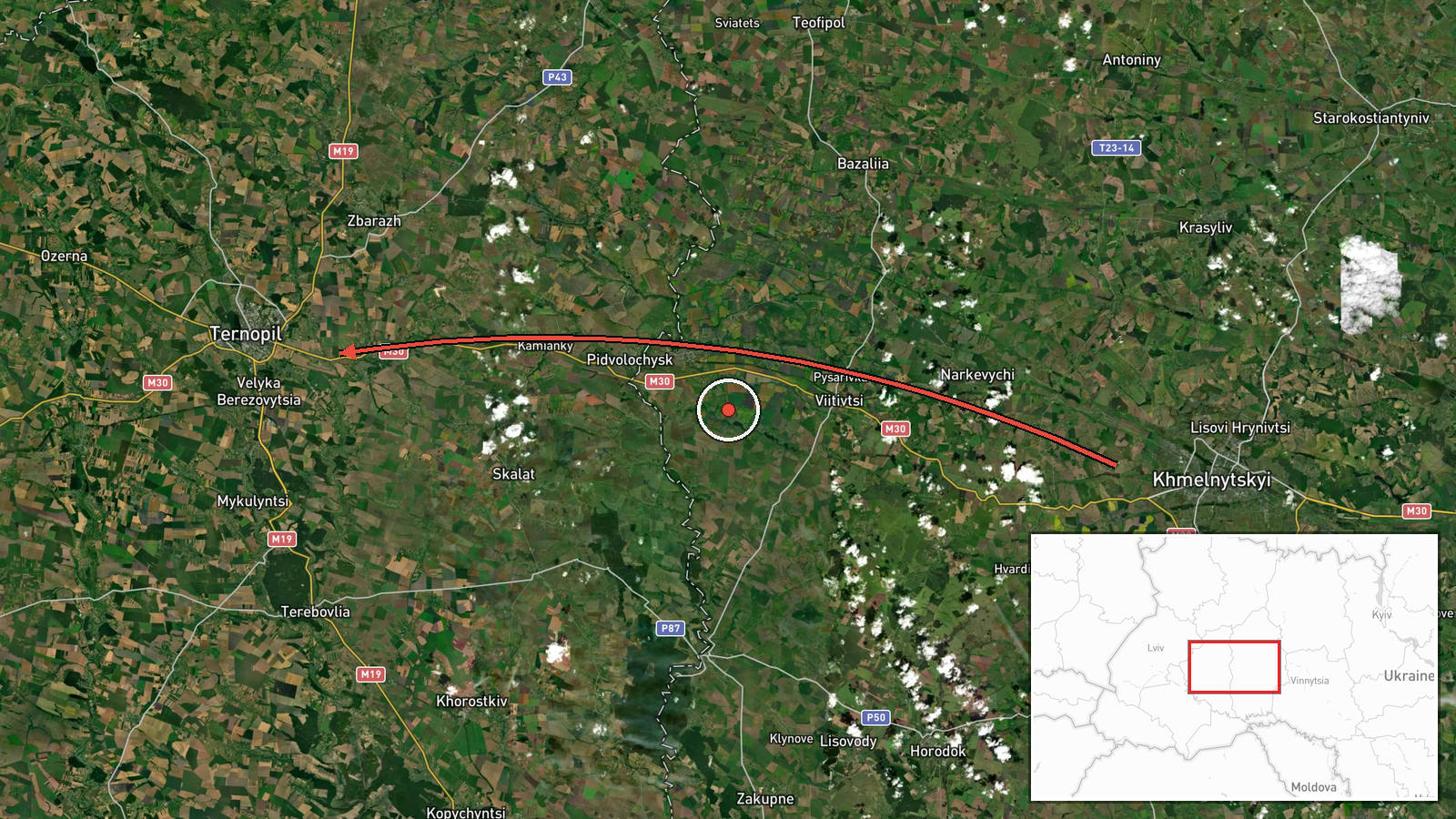
Ukrainian air monitoring channel @kpszsu reported on 20 October 2026, at 03:12 UTC, that one Russian Shahed-type drone was passing Khmelnytskyi and heading toward Ternopil Oblast in western Ukraine. The alert is a transit notice rather than a report of impact, and it names no strike target or damage. The original Ukrainian wording, "Повз Хмельницький ➡️ на Тернопільщину", roughly means "past Khmelnytskyi, toward Ternopil region," and the English summary adds the Shahed-type classification. The location is recorded only at regional level, so the exact track and final point of the drone are not established by this report. No casualties, fires or intercepts are mentioned in the source.
Context and assessment
Ternopil Oblast has appeared repeatedly in the preceding hours of this feed. Between 23:33 UTC on 19 October and 02:41 UTC on 20 October, the monitoring channel logged several further drones moving through the same region, including reports near Horodok and Skalat and one passing Kozova toward Ivano-Frankivsk Oblast. Most of these were described as jet-powered Geran-3 variants, and the sequence points to a sustained air corridor through western Ukraine rather than a single isolated sortie. Such routing is consistent with long-range one-way attack drones being directed deep into the west, where they can threaten logistics hubs, energy infrastructure and rail links that sit well away from the front line. The pattern also fits a practice of sending individual drones on staggered routes, which can stretch air defence and early warning coverage. On the available evidence, this event looks like one segment of an ongoing transit pattern rather than a discrete targeted strike. Its operational purpose cannot be confirmed from transit alerts alone.
Sources and confidence
The report comes from a single Telegram channel, @kpszsu, which is associated with Ukrainian air monitoring and carries the air alert style of messages. No second outlet is listed as having independently confirmed this specific transit, so cross-confirmation is absent. The confidence score of 8.0 reflects a credible official-style channel with a consistent track record in this feed, offset by the single-source status and the lack of a precise position. Confidence would rise if the reading were matched by other monitoring outlets, by regional military administration statements, or by reports of impact or interception along the stated route. It would fall if later updates contradicted the direction of travel or if the track could not be corroborated by the related alerts.
Location
The location is recorded as Ternopil Oblast, Ukraine, at approximate regional precision with low location confidence. The coordinates, 49.55 N and 25.59 E, place the point near the centre of the oblast rather than at any named settlement, because the source names only the region as the drone's destination. Ternopil Oblast lies in western Ukraine, bordering Poland to the west and sitting north of the Carpathian foothills. The terrain is largely rolling agricultural plain with river valleys, and the region contains several mid-sized towns and rail and road routes linking eastern and western Ukraine. Khmelnytskyi, named in the report as the drone's previous position, lies to the northeast.
Related events nearby
- Ukrainian air monitoring: 1 Russian jet-powered Shahed (Geran-3) drone passing Ternopil Oblast, heading northw2026-10-20 00:33 UTC · Drone Transit · Ternopil Oblast, Ukraine
- Ukrainian air monitoring: 1 Russian jet-powered Shahed (Geran-3) drone heading toward Ternopil Oblast.2026-10-19 23:33 UTC · Drone Transit · Ternopil Oblast, Ukraine
- Ukrainian air monitoring: 1 Russian jet-powered Shahed (Geran-3) drone from Ternopil Oblast toward Skalat.2026-10-20 03:53 UTC · Drone Transit · Skalat, Ukraine
- Ukrainian air monitoring: 1 Russian jet-powered Shahed (Geran-3) drone heading toward Skalat.2026-10-20 02:30 UTC · Drone Transit · Skalat, Ukraine
- Ukrainian air monitoring: 1 Russian Shahed-type drone passing Horodok, heading northwest.2026-10-20 00:17 UTC · Drone Transit · Horodok, Ukraine
▶ View this event on the live map

Intel Mapper aggregates open-source reports from monitored Telegram and X channels, geolocates them, cross-checks duplicates across sources and assigns a confidence score. Entries are updated as new confirmations arrive. Read how we verify events.