Jet-powered Shahed drones reported passing Olevsk toward Rivne Oblast, Ukraine
What happened
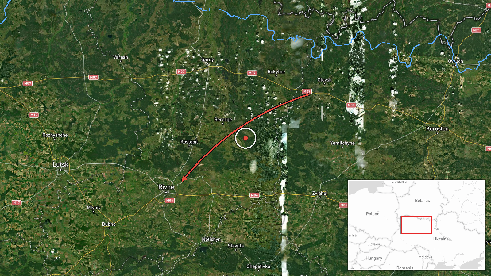
A Ukrainian air monitoring post on the Telegram channel @kpszsu reports that two or more Russian jet-powered Shahed (Geran-3) drones were passing Olevsk and Horodnytsia in Zhytomyr Oblast and heading toward Rivne Oblast. The event is timestamped 04:35 UTC on 20 October 2026. The original Ukrainian wording refers to jet-type UAVs moving past the two settlements on their way into Rivne Oblast, language that describes transit rather than a confirmed strike. The source reports no impacts, casualties, or damage, and no other channel had published corroboration at the time of this entry. Attribution to Russia rests on the source's identification of the Geran-3 type.
Context and assessment
The entry sits within a dense cluster of drone transit reports issued between 01:43 and 04:35 UTC on the same night. Earlier entries describe a single Geran-3 moving from Zhytomyr Oblast toward Rivne Oblast at 01:44, another heading toward Rivne at 01:43, and a group of two or more drones approaching Rivne at 01:50. Later reports place one drone passing Horodnytsia at 03:06 and another heading toward Rivne city at 03:10. The pattern shows a repeated corridor of northwestward movement across the Zhytomyr to Rivne axis, with reported group sizes rising from one to two or more over several hours. Rivne is a regional centre in northwestern Ukraine, and the sequence of reports suggests the drones were tracked as they crossed several districts rather than being aimed at a single known site. Operationally, a series of tracks along one corridor may reflect a sustained overnight launch, multiple waves, or drones routed to avoid defenses in other areas. Because the related reports do not name targets, the sequence should be read as evidence of movement and air-defense tracking, not as an indication of intended objectives.
Sources and confidence
The event rests on a single Telegram channel, @kpszsu, which publishes Ukrainian air monitoring alerts. The related events in the same window also appear as air monitoring entries, but the data does not show whether they came from the same channel or from independent sources. No wire service, official statement, or second channel is recorded for this specific report. The confidence score of 8.0 reflects a clear, specific, and consistent source that names the drone type and route, but it is held below the top of the scale because the report is unconfirmed by any second source. Confidence would rise with independent corroboration from another monitoring channel, regional military administration statements, or imagery. It would fall if later reports contradicted the drone type or route.
Location
The coordinates (50.62, 26.25) correspond to central Rivne city, not to the rest of the reported corridor. Geo precision is recorded as region level and location confidence as low, so the point should be read as a placeholder for Rivne Oblast rather than a track position. Olevsk and Horodnytsia lie in northern Zhytomyr Oblast, within the Polesia lowlands, an area of forest, wetlands, and river valleys. Rivne Oblast lies to the west and southwest, and the drone route is described as moving across this lowland region.
Related events nearby
- Ukrainian air monitoring: 1 Russian jet-powered Shahed (Geran-3) drone heading toward Rivne.2026-10-20 03:10 UTC · Drone Transit · Rivne, Ukraine
- Ukrainian air monitoring: 1 Russian jet-powered Shahed (Geran-3) drone passing Horodnytsia, heading toward Riv2026-10-20 03:06 UTC · Drone Transit · Rivne Oblast, Ukraine
- Ukrainian air monitoring: 2+ Russian jet-powered Shahed (Geran-3) drones heading toward Rivne.2026-10-20 01:50 UTC · Drone Transit · Rivne, Ukraine
- Ukrainian air monitoring: 1 Russian jet-powered Shahed (Geran-3) drone from Zhytomyr Oblast toward Rivne Oblas2026-10-20 01:44 UTC · Drone Transit · Rivne Oblast, Ukraine
- Ukrainian air monitoring: 1 Russian jet-powered Shahed (Geran-3) drone heading toward Rivne.2026-10-20 01:43 UTC · Drone Transit · Rivne, Ukraine
▶ View this event on the live map

Intel Mapper aggregates open-source reports from monitored Telegram and X channels, geolocates them, cross-checks duplicates across sources and assigns a confidence score. Entries are updated as new confirmations arrive. Read how we verify events.