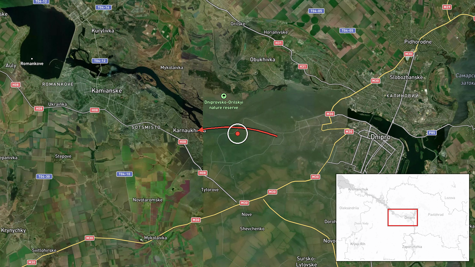
Jet-powered Geran-3 drone reported heading toward Karnaukhivka, Dnipropetrovsk Oblast
What happened
Ukrainian air monitoring reports, relayed through the Telegram channel @kpszsu, state that on 20 October 2026 at 06:30 UTC a single jet-powered Shahed-type drone, identified as a Geran-3, was moving toward the settlement of Karnaukhivka in Dnipropetrovsk Oblast. The original Ukrainian-language post describes the drone as approaching from the south. The report does not describe any impact, damage, or casualties, and it does not identify a specific target within the village. The event is logged as a drone transit, meaning an aircraft tracked in flight rather than a confirmed strike. Attribution to Russia rests on the drone type, which is associated with Russian forces in the ongoing war, and on the monitoring channel's own tracking.
Context and assessment
This track sits within a dense sequence of alerts over Dnipropetrovsk Oblast in the preceding hours. At 23:02 on 19 October, groups of Shahed-type drones were tracked south of Kamianske on a westward course. Between 02:04 and 02:05 on 20 October, drones were reported inbound to Dnipro from the southeast, and a guided glide bomb was reported heading toward the city. At 04:36, two or more Geran-3 drones were reported passing through the oblast heading west, and at 05:20 another Geran-3 was reported heading toward Dnipro. The Karnaukhivka alert follows about an hour later. Taken together, the pattern suggests a sustained overnight and early-morning wave with drones moving along several axes, some westward and some toward Dnipro. A single drone tracked toward a smaller settlement could plausibly be a decoy, a reconnaissance asset, or an aircraft diverted from or following a corridor toward a larger objective. The available reporting does not confirm which, and the alert alone does not establish intent.
Sources and confidence
The event rests on a single Telegram channel, @kpszsu, which is widely understood to be an official Ukrainian Air Force monitoring account. No independent outlet, regional administration, or second monitoring source is attached to this entry, and the record is not marked as corrected. The confidence score of 8.0 reflects an official-source origin and a specific, time-stamped report, offset by the absence of cross-confirmation and the transient nature of drone tracks. Confidence would rise with corroboration from regional military administration statements, impact or debris reports, or other monitoring channels confirming the track. It would fall if later official updates revise the direction, type, or destination, or if no subsequent reporting references the drone.
Location
The location is recorded at settlement precision, placing the point on Karnaukhivka itself, with high location confidence. This is a village-level geocode rather than a facility, so the point marks the named settlement and not a specific installation. Karnaukhivka lies in Dnipropetrovsk Oblast in central-eastern Ukraine, an area of open steppe crossed by the Dnipro River and its associated reservoirs. The wider corridor includes the city of Dnipro and several smaller settlements that have appeared repeatedly in recent alerts.
Related events nearby
- Ukrainian air monitoring: groups of Russian jet-powered Shahed-type drones tracked south of Kamianske on a wes2026-10-19 23:02 UTC · Drone Transit · Kamianske, Dnipropetrovsk Oblast, Ukraine
- Ukrainian air monitoring: 1 Russian guided glide bomb (KAB) heading toward Dnipro.2026-10-20 02:05 UTC · Airstrike · Dnipro, Ukraine
- Ukrainian air monitoring reports Russian drone(s) inbound toward Dnipro from the southeast.2026-10-20 02:04 UTC · Drone Transit · Dnipro, Dnipropetrovsk Oblast, Ukraine
- Ukrainian air monitoring: 1 Russian jet-powered Shahed (Geran-3) drone heading toward Dnipro.2026-10-20 06:47 UTC · Drone Transit · Dnipro, Ukraine
- Ukrainian air monitoring: 1 Russian jet-powered Shahed (Geran-3) drone heading toward Dnipro.2026-10-20 05:20 UTC · Drone Transit · Dnipro, Ukraine
▶ View this event on the live map

Intel Mapper aggregates open-source reports from monitored Telegram and X channels, geolocates them, cross-checks duplicates across sources and assigns a confidence score. Entries are updated as new confirmations arrive. Read how we verify events.