Single jet-powered Shahed (Geran-3) reported transiting Kyiv Reservoir toward Vyshhorod
What happened
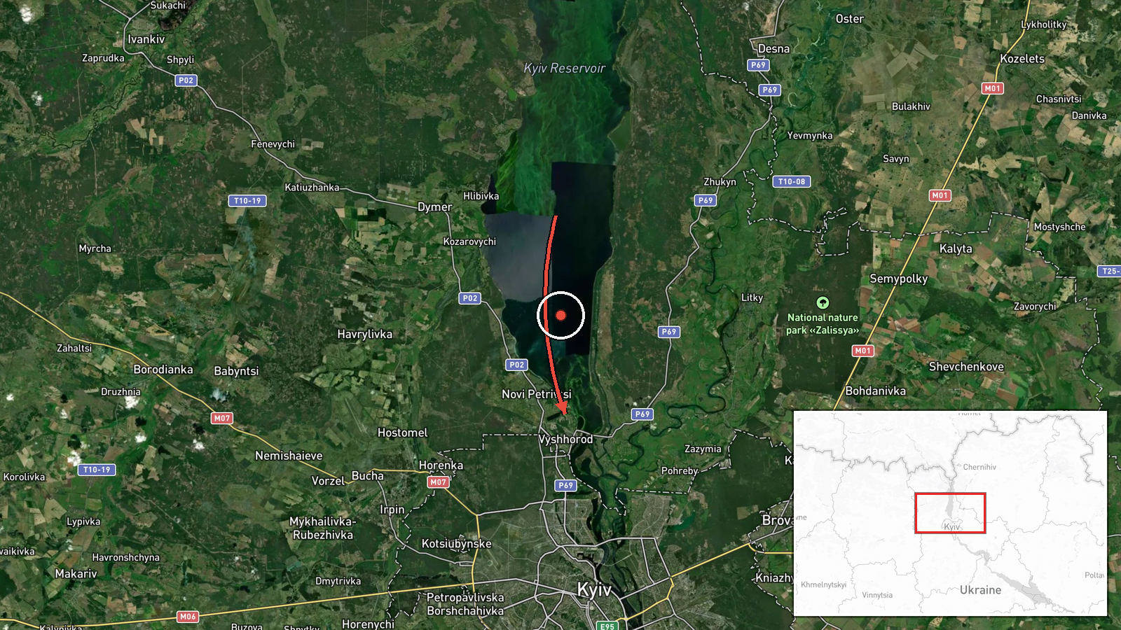
On 20 October 2026, at about 11:07 UTC, Ukraine's air monitoring channel Telegram (@kpszsu) reported one Russian jet-powered Shahed (Geran-3) drone passing the Kyiv Reservoir on a course toward Vyshhorod and Kyiv. The original Ukrainian-language post describes it as a jet-powered UAV flying past the reservoir, with the heading given as Vyshhorod/Kyiv. The report is a brief monitoring notice and does not describe any impact, damage, or casualties. It appears as part of a series of drone transit alerts issued across the Kyiv area over the preceding hour and a half, beginning at about 09:49 UTC.
Context and assessment
Vyshhorod sits on the Dnipro-side approaches to northern Kyiv, and the Kyiv Reservoir is a long, visible water body that drones often follow as a navigational feature toward the capital. Within the monitoring window, the related alerts show a steady progression of single and multiple Geran-3 drones moving from the Kyiv city outskirts (Boyarka, Brovary) to Shuliavka and Makariv in Kyiv Oblast, which suggests a sustained air raid pattern rather than a one-off sortie. Reports of individual drones heading toward Kyiv with multiple tracks in the same hour are consistent with a broader launch wave being tracked as it moves through the region. Geran-3 is the jet-powered variant of the Shahed design, generally faster and harder to intercept with older low-speed countermeasures than piston-engine versions. Its appearance in this sequence may indicate that the attack is aimed at the capital and its surroundings, though the single-drone entry itself does not establish intent or a specific target. Operationally, this type of alert mainly signals that air defence units and population warning systems are being activated along the flight path.
Sources and confidence
The event rests on one Telegram channel, @kpszsu, which is an official Ukrainian air force-linked monitoring account and is generally regarded as a timely primary source for airspace tracking. No second independent channel is listed in the data, and the related alerts come from the same source type, so they reinforce the pattern but do not independently verify this specific track. The confidence score of 8.0 reflects an official-source origin and a clear, specific description, offset by single-channel reporting and the absence of corroborating imagery or wreckage. Confidence would rise with confirmation from a second monitoring feed, a reported interception or impact location, or wreckage imagery; it would fall if the track were later revised or corrected.
Location
The location is given at settlement level for Vyshhorod, Ukraine, at approximately 50.583 N, 30.486 E, with high location confidence. The coordinates refer to the town as a whole rather than a specific facility, since the report names only the course and not a point on it. Geographically, Vyshhorod lies on the right bank of the Dnipro just north of Kyiv, with the Kyiv Reservoir extending nearby to the north and west and forested river terrain around it.
Related events nearby
- Ukrainian air monitoring: 2+ Russian jet-powered Shahed (Geran-3) drones heading toward Vyshhorod.2026-10-20 11:42 UTC · Drone Transit · Vyshhorod, Ukraine
- Ukrainian air monitoring: 1 Russian jet-powered Shahed (Geran-3) drone heading toward Pochaina, Kyiv.2026-10-20 12:42 UTC · Drone Transit · Pochaina, Kyiv, Ukraine
- Ukrainian air monitoring: 1 Russian jet-powered Shahed (Geran-3) drone heading toward Pochaina, Kyiv.2026-10-20 12:34 UTC · Drone Transit · Pochaina, Kyiv, Ukraine
- Ukrainian air monitoring: 1 Russian jet-powered Shahed (Geran-3) drone heading toward Shuliavka, Kyiv.2026-10-20 10:20 UTC · Drone Transit · Shuliavka, Kyiv, Ukraine
- Ukrainian air monitoring reports Russian jet-powered Shahed (Geran-3) drones tracked over Shuliavka and the Mi2026-10-20 12:08 UTC · Drone Transit · Shuliavka, Kyiv, Ukraine
▶ View this event on the live map

Intel Mapper aggregates open-source reports from monitored Telegram and X channels, geolocates them, cross-checks duplicates across sources and assigns a confidence score. Entries are updated as new confirmations arrive. Read how we verify events.