Two or more jet-powered Shahed drones tracked toward Bila Tserkva from eastern Kyiv Oblast
What happened
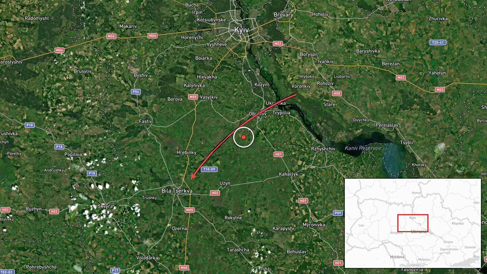
Ukrainian air monitoring reported at 13:58 UTC on 20 October 2026 that at least two jet-powered Shahed-type drones, identified in the report as Geran-3, were moving from the eastern part of Kyiv Oblast toward Bila Tserkva. The alert was posted in Ukrainian on Telegram. The original wording describes jet-type unmanned aerial vehicles on the eastern edge of the Kyiv region heading in the direction of Bila Tserkva. The report does not say whether any drones were intercepted, struck a target, or caused damage, and it gives no impact location. It is a transit warning rather than a confirmed strike, so the outcome remains unknown from this source alone.
Context and assessment
Bila Tserkva sits on the Ros River roughly 80 km south of Kyiv, on the road and rail corridors linking the capital with central and southern Ukraine, which makes it a regional transport and industrial node. The current report is the latest in a sequence of five related alerts over less than 24 hours. At 15:43 on 19 October one Geran-3 was reported from Kyiv Oblast toward Fastiv. At 16:04 two or more were reported passing Rzhyshchiv toward Obukhiv. Single and multiple drones were then reported heading toward Bila Tserkva at 17:52, 18:25 and 19:23. The pattern points to a sustained flight path through the Kyiv region toward the Bila Tserkva area rather than one isolated wave. Operationally, repeated reports along one corridor may reflect drones routed toward a distant aim point, or a test of air defense and warning systems, but the data cannot distinguish between these. Jet-powered Geran-3 variants are faster than the older piston-engine Shaheds, which would shorten warning time for communities along the route. Any inference about targeting should be treated as provisional.
Sources and confidence
Only one channel, the Telegram account @kpszsu, carries this report, so there is no cross-confirmation and the source count is one. The confidence score of 8.0 reflects the channel's established role in publishing Ukrainian air monitoring alerts and the consistency of this report with the earlier alerts in the same area. It is not independently verified. Confidence would rise with corroboration from Kyiv Oblast or Bila Tserkva officials, or from reports of interceptions or impacts in the area. It would fall if the monitoring channel corrected the drone count or route, or if later alerts retracted the track.
Location
The location is recorded at settlement level for Bila Tserkva in Kyiv Oblast, at approximately 49.8 N, 30.12 E. Location confidence is high because the report names the city directly, but the alert does not identify any facility, so the map pin marks the town rather than a specific site. Bila Tserkva lies on the Ros River, a tributary of the Dnipro, in a largely flat landscape of farmland and woodland south of the capital.
Related events nearby
- Ukrainian air monitoring: 1 Russian jet-powered Shahed (Geran-3) drone heading toward Bila Tserkva.2026-10-19 19:23 UTC · Drone Transit · Bila Tserkva, Ukraine
- Ukrainian air monitoring: 2+ Russian jet-powered Shahed (Geran-3) drones from Kyiv Oblast toward Bila Tserkva.2026-10-19 18:25 UTC · Drone Transit · Bila Tserkva, Ukraine
- Ukrainian air monitoring: 1 Russian jet-powered Shahed (Geran-3) drone heading toward Bila Tserkva.2026-10-19 17:52 UTC · Drone Transit · Bila Tserkva, Ukraine
- Ukrainian air monitoring: 1 Russian jet-powered Shahed (Geran-3) drone from Kyiv Oblast toward Fastiv.2026-10-19 15:43 UTC · Drone Transit · Fastiv, Ukraine
- Ukrainian air monitoring: 2+ Russian jet-powered Shahed (Geran-3) drones passing Rzhyshchiv, heading toward Ob2026-10-19 16:04 UTC · Drone Transit · Obukhiv, Ukraine
▶ View this event on the live map

Intel Mapper aggregates open-source reports from monitored Telegram and X channels, geolocates them, cross-checks duplicates across sources and assigns a confidence score. Entries are updated as new confirmations arrive. Read how we verify events.