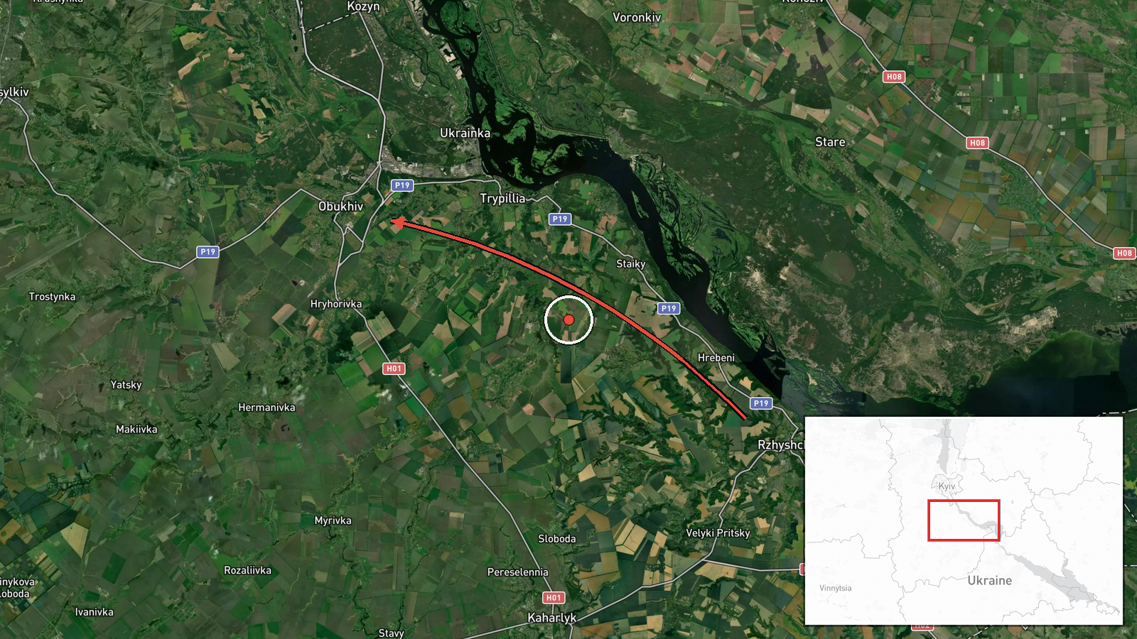
Jet-powered Shahed-type drones reported moving past Rzhyshchiv toward Obukhiv, Kyiv Oblast
What happened
Ukraine's Air Force monitoring channel on Telegram (@kpszsu) posted on 19 October 2026 at 16:04 UTC that at least two jet-powered unmanned aerial vehicles were moving past Rzhyshchiv in the direction of Obukhiv. The original Ukrainian wording is brief: 'Jet-powered UAVs past Rzhyshchiv, heading toward Obukhiv,' accompanied by a directional arrow. The post does not report impacts, casualties, or damage, and it does not say whether the drones were engaged. The event summary attributes the drones to Russia and identifies them as Geran-3 jet-powered Shaheds. That attribution and designation rest on the channel's framing and the summary, not on independent imagery or wreckage analysis. The report should be read as a transit notice rather than a confirmed strike.
Context and assessment
Obukhiv sits in Kyiv Oblast, south-east of the capital, and the wider area has repeatedly come under air attack as Russian long-range strikes have targeted Kyiv and its surroundings. The report follows a significant ballistic missile strike the previous evening, when missiles reportedly hit thermal power plants TPP-5 in Vydubychi and TPP-6 in Troyeshchyna, with further strikes on southern Kyiv. A related summary references estimates of up to 16 ballistic missiles available for such raids. Separately, Ukrainian President Zelensky stated on the same day that high-speed equipment failures are hampering frontline logistics and limiting mid-strike drones and the jet interceptors used against Shaheds. If accurate, that constraint would make jet-powered drones harder to counter, which may explain why their movement is being flagged publicly. Operationally, a transit toward Obukhiv could indicate a route along the Kyiv approaches, a decoy or saturation element within a larger combined raid, or a drone group redirected after launch. The single post cannot distinguish among these possibilities.
Sources and confidence
The event rests on one channel, the Telegram account @kpszsu, and the dataset records no independent cross-confirmation, so the source count is one. The confidence score of 8.0 reflects that the channel is an official Ukrainian air monitoring source with a direct operational role and that the report fits a documented pattern of nearby raids the previous evening. It is still a single brief post without imagery, track data, or local corroboration, and the record is not marked as corrected. Confidence would rise with matching reports from other official channels, local sirens or debris reports in Obukhiv, or open-source flight tracking. It would fall if the drone type, count, or direction were revised, or if later reporting described the sighting differently.
Location
The coordinates are given at settlement precision and the location confidence is recorded as high, so the point marks Obukhiv itself rather than a facility. The geography is largely flat, with river valleys and wetlands associated with the Dnipro system and a mix of farmland, settlements, and forest belts. The area lies within the approaches to Kyiv from the south-east, where the terrain offers few natural barriers to low-flying aerial systems. Rzhyshchiv, named in the report as a waypoint, is a town on the Dnipro that marks a visible reference point along the transit path.
Related events nearby
- Ballistic missiles directly struck TPP-5 in Vydubychi and TPP-6 in Troyeschyna, with further strikes on southe2026-10-18 20:04 UTC · Ballistic Missile · TPP-5, Vydubychi, Kyiv, Ukraine
- Zelensky says high-speed equipment failures (130–161 km/h) are hampering frontline logistics and limiting mid-2026-10-19 14:49 UTC · Statement · Kyiv, Ukraine
- Zelensky offers to halt strikes on Russian diesel facilities in exchange for Patriot missiles, and accuses Was2026-10-19 05:57 UTC · Statement · Kyiv, Ukraine
- Ukrainian General Staff publishes cumulative Russian combat loss tally covering 24.02.22 to 19.10.26.2026-10-19 03:48 UTC · Report · Kyiv, Ukraine
- Zelensky says Trump has a good relationship with Putin but cannot force Putin to end the war.2026-10-18 20:22 UTC · Statement · Kyiv, Ukraine
▶ View this event on the live map

Intel Mapper aggregates open-source reports from monitored Telegram and X channels, geolocates them, cross-checks duplicates across sources and assigns a confidence score. Entries are updated as new confirmations arrive. Read how we verify events.