Single Russian Shahed-type drone reported heading toward Rybakivka, Mykolaiv Oblast
What happened
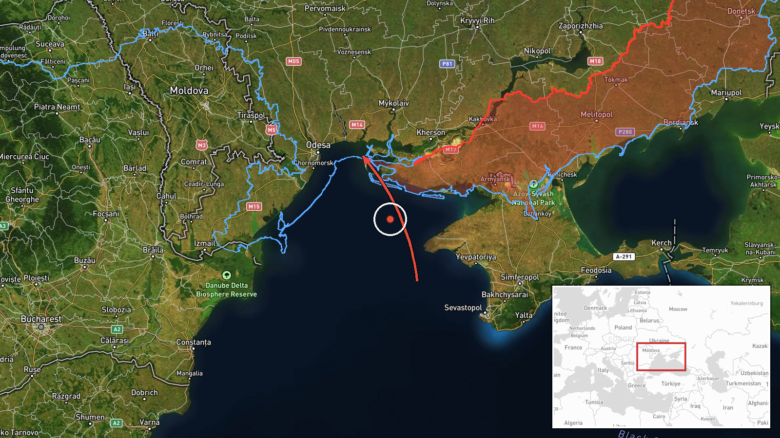
Ukrainian air monitoring reportedly tracked one Russian Shahed-type drone entering from the Black Sea and heading toward Rybakivka, a settlement in Mykolaiv Oblast, in a post timed 15:47 UTC on 20 October 2026. The original Ukrainian-language message describes a UAV from the Black Sea area on a course toward the Mykolaiv region, with Rybakivka named in parentheses. The report does not describe impact, damage, casualties or interception, and the wording suggests only a flight track was observed. The data identifies the channel as Telegram account @kpszsu. The event is classed as a drone transit rather than a confirmed strike.
Context and assessment
Rybakivka lies in the Mykolaiv area, a coastal corridor that Russian long-range drones have repeatedly crossed on routes toward Odesa and Mykolaiv oblasts. This entry is the latest in a short run of transit reports on the same axis. On 19 October at 20:58 UTC, a jet-powered Shahed identified as Geran-3 was tracked from the Black Sea toward Ochakiv. The next morning, between 06:30 and 10:11 UTC, the monitoring feed logged a sequence of Geran-3 tracks: first passing eastern Odesa Oblast heading west, then several reports at Berezanka, one heading toward it at 07:46 and others passing it at 08:44 and 10:11, the last heading northwest. The pattern suggests individual drones moving along a coastal approach that bends northwest from the Black Sea. Operationally, repeated single-drone tracks in this corridor may indicate routine launches meant to stretch air defence attention, probe radar coverage, or reach targets further inland. Such reports do not on their own confirm a target. The Rybakivka entry rests on one report, and its link to the earlier drones depends on geographic proximity and shared pattern rather than a confirmed flight path.
Sources and confidence
Only one channel is listed: Telegram account @kpszsu, which posts Ukrainian air monitoring alerts. No second outlet, wire service or official statement in this dataset independently confirms the track, so the item rests on a single source. The 8.0 score reflects a recurring alert feed with a consistent pattern in related events, offset by the lack of corroboration and the general nature of the wording. Confidence would rise with confirmation from an official Ukrainian air force or regional military administration statement, or from public flight-tracking data. It would fall if later updates retract or amend the location, or if no related reports surface.
Location
The location is settlement-level with high location confidence, placed at Rybakivka in Ukraine at approximately 46.623 N, 31.365 E. The settlement lies in Mykolaiv Oblast on the southern Ukrainian coast, in the Black Sea littoral between Odesa and Mykolaiv. The surrounding terrain is largely flat steppe and estuary landscape, with the Dnipro-Buh estuary and the Black Sea coastline in the broader area. The exact drone position at the time of the report is not specified.
Related events nearby
- Ukrainian air monitoring: 1 Russian jet-powered Shahed (Geran-3) drone from Black Sea toward Ochakiv.2026-10-19 20:58 UTC · Drone Transit · Ochakiv, Ukraine
- Ukrainian air monitoring: 1 Russian jet-powered Shahed (Geran-3) drone passing Berezanka, heading northwest.2026-10-20 10:11 UTC · Drone Transit · Berezanka, Ukraine
- Ukrainian air monitoring: 1 Russian jet-powered Shahed (Geran-3) drone passing Berezanka, heading northwest.2026-10-20 08:44 UTC · Drone Transit · Berezanka, Ukraine
- Ukrainian air monitoring: 1 Russian jet-powered Shahed (Geran-3) drone heading toward Berezanka.2026-10-20 07:46 UTC · Drone Transit · Berezanka, Ukraine
- Ukrainian air monitoring: 1 Russian jet-powered Shahed (Geran-3) drone passing eastern Odesa Oblast, heading w2026-10-20 06:30 UTC · Drone Transit · eastern Odesa Oblast, Ukraine
▶ View this event on the live map

Intel Mapper aggregates open-source reports from monitored Telegram and X channels, geolocates them, cross-checks duplicates across sources and assigns a confidence score. Entries are updated as new confirmations arrive. Read how we verify events.