Jet-powered Shahed (Geran-3) drone reported transiting Ternopil Oblast toward the west, Ukraine
What happened
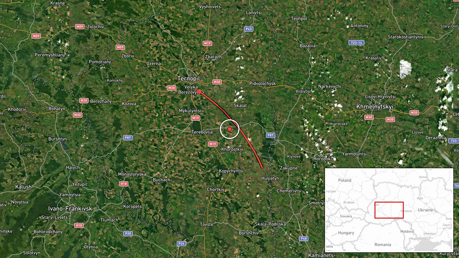
Ukrainian air monitoring reported on Telegram, via the channel @kpszsu, that a single Russian jet-powered Shahed-type drone, identified in the report as a Geran-3, was moving from Khmelnytskyi Oblast into Ternopil Oblast and passing near Husiatyn on a westward heading. The message, timestamped 21 October 2026 at 02:16 UTC, describes a transit rather than a strike. It does not report impact, damage, casualties or any air-defence engagement. The original Ukrainian wording refers to the drone flying past Husiatyn, and the English summary uses the same settlement name. The report is a single-source operational alert, so its details rest on one monitoring channel's assessment of the drone's track.
Context and assessment
Husiatyn sits in the southeast of Ternopil Oblast along the Zbruch River, close to the boundary with Khmelnytskyi Oblast, so a drone entering from Khmelnytskyi and heading west would pass through this area on its way deeper into western Ukraine. The related reports show a sustained sequence of Geran-3 transits across the same corridor on 20 October 2026: a Shahed-type drone entering Ternopil Oblast from Khmelnytskyi, several jet-powered drones tracked toward or from Skalat, one heading toward Burshtyn, and one from Lviv Oblast toward Lopatyn. The pattern is consistent with multiple drones using overlapping western routes, although the timestamps in the related feed are not in chronological order and should be read as individual alerts rather than a verified sequence. Operationally, repeated transits through this belt may indicate routing toward targets further west or north, or may reflect drones being tracked over an extended flight path. The reports alone do not establish destination or intent. Jet-powered variants are generally faster than the piston-engine Shahed models, which can shorten the warning window for air-defence and civil alert systems, a point that matters when the same region is crossed repeatedly within hours.
Sources and confidence
The report comes from a single Telegram channel, @kpszsu, which is widely understood to be a Ukrainian air-force-linked feed used for real-time airspace alerts. No second channel, wire service or official statement in the supplied data corroborates it, so cross-confirmation status is single-source. The confidence score of 8.0 reflects a credible, specialised monitoring origin and a clearly specified drone type, offset by the absence of corroboration and the low location confidence. The score would rise with independent confirmation from another monitoring source or an official alert, or with observed tracks matching the reported heading. It would fall if later updates contradict the route, or if the channel revises or retracts the report.
Location
The location is recorded as Ternopil Oblast at region-level precision, with low location confidence. The coordinates (49.55, 25.59) fall near the city of Ternopil rather than Husiatyn, so they should be treated as an oblast-level placeholder and not as a point on the drone's track. Ternopil Oblast is a largely agricultural region in western Ukraine. Husiatyn lies on the Zbruch River near the Khmelnytskyi boundary, and that river corridor is the most relevant local terrain feature for this transit.
Related events nearby
- Ukrainian air monitoring: 1 Russian Shahed-type drone passing Khmelnytskyi, heading toward Ternopil Oblast.2026-10-20 03:12 UTC · Drone Transit · Ternopil Oblast, Ukraine
- Ukrainian air monitoring: 1 Russian jet-powered Shahed (Geran-3) drone from Ternopil Oblast toward Skalat.2026-10-20 03:53 UTC · Drone Transit · Skalat, Ukraine
- Ukrainian air monitoring: 1 Russian jet-powered Shahed (Geran-3) drone from Ternopil Oblast toward Burshtyn.2026-10-20 11:48 UTC · Drone Transit · Burshtyn, Ukraine
- Ukrainian air monitoring: 1 Russian jet-powered Shahed (Geran-3) drone from Lviv Oblast toward Lopatyn.2026-10-20 08:16 UTC · Drone Transit · Lopatyn, Ukraine
- Ukrainian air monitoring: 1 Russian jet-powered Shahed (Geran-3) drone passing Ivano-Frankivsk Oblast, heading2026-10-20 04:12 UTC · Drone Transit · Ivano-Frankivsk Oblast, Ukraine
▶ View this event on the live map

Intel Mapper aggregates open-source reports from monitored Telegram and X channels, geolocates them, cross-checks duplicates across sources and assigns a confidence score. Entries are updated as new confirmations arrive. Read how we verify events.