Russian Shahed-type drone reported heading toward Uman, Cherkasy Oblast, via Kirovohrad Oblast
What happened
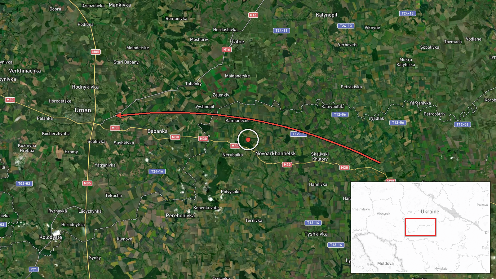
Ukraine's air monitoring channel reported one jet-powered Shahed-type drone, identified in the message as a Geran-3, moving through Kirovohrad Oblast on a course toward Cherkasy Oblast and the city of Uman. The alert was posted at 04:42 UTC on 21 October 2026. The original Ukrainian-language message describes a jet UAV flying toward Cherkasy region, with Uman named in parentheses. It does not report impact, damage, casualties, or interception, and the event is logged as a drone transit rather than a strike. Because this is a route warning, the mapped point reflects the stated destination, and the message gives no arrival time or confirmation of the drone's final position.
Context and assessment
Uman sits in Cherkasy Oblast in central Ukraine. It is a rail and road junction and the home of the Sofiivka Park landscape complex, and it lies well north of the front lines in the east and south. Its significance in a monitoring feed is less about the city itself than about the corridor it sits on. Drones crossing central oblasts can be routed toward targets farther west or north, and each new warning shows how air defense coverage is being tracked. The five related entries in the Intel Mapper record show the same type of object moving through a sequence of central Ukrainian districts over roughly a day, with alerts naming Hayvoron, Kryzhopil and Rudnytsya. A separate earlier entry from 21 October also names Uman. Together the pattern suggests one or more drones being followed through successive waypoints, although the records do not establish whether these are the same airframe or distinct launches. Operationally, repeated transit alerts of this kind are generally associated with long-range one-way attack drones being moved toward deeper targets, and with air defense units shifting coverage. Nothing in this report confirms an intended target or a specific strike.
Sources and confidence
The report comes from a single Telegram channel, @kpszsu, which relays official alerts from Ukraine's air monitoring. The Intel Mapper record lists one source and no wire service, government statement, or open-source imagery corroborating it. The confidence score of 8.0 reflects a credible official-style channel that is widely used for these alerts and a clear, specific message, offset by the lack of a second source and the fact that route warnings are not always followed by confirmed events. Confidence would rise if the air force, regional military administrations, or local officials confirmed the track or reported debris or impact. It would fall if the drone were later reported as lost, redirected, or not observed near Uman.
Location
The point is set to the settlement of Uman at approximately 48.75 N, 30.22 E. Location confidence is high because the message names the city directly, but precision is settlement-level rather than facility-level. Uman lies in the Cherkasy region of central Ukraine on the Umanka river, in a transitional landscape of farmland and forest-steppe. The nearest notable feature is Sofiivka Park, a landscaped estate on the town's edge. The reference to Kirovohrad region marks the drone's reported entry area, not a second location.
Related events nearby
- Ukrainian air monitoring: 1 Russian jet-powered Shahed (Geran-3) drone heading toward Uman.2026-10-21 03:16 UTC · Drone Transit · Uman, Ukraine
- Ukrainian air monitoring: 1 Russian jet-powered Shahed (Geran-3) drone from Kirovohrad Oblast toward Hayvoron.2026-10-20 08:43 UTC · Drone Transit · Hayvoron, Ukraine
- Ukrainian air monitoring: 1 Russian jet-powered Shahed (Geran-3) drone from Vinnytsia Oblast toward Berezivka.2026-10-21 05:08 UTC · Drone Transit · Berezivka, Ukraine
- Ukrainian air monitoring: 1 Russian jet-powered Shahed (Geran-3) drone heading toward Kryzhopil.2026-10-20 11:12 UTC · Drone Transit · Kryzhopil, Ukraine
- Ukrainian air monitoring: 1 Russian jet-powered Shahed (Geran-3) drone from Vinnytsia Oblast toward Kryzhopil.2026-10-20 08:58 UTC · Drone Transit · Kryzhopil, Ukraine
▶ View this event on the live map

Intel Mapper aggregates open-source reports from monitored Telegram and X channels, geolocates them, cross-checks duplicates across sources and assigns a confidence score. Entries are updated as new confirmations arrive. Read how we verify events.