Russian jet-powered Shahed drone reported moving from Vinnytsia Oblast toward Kryzhopil
What happened
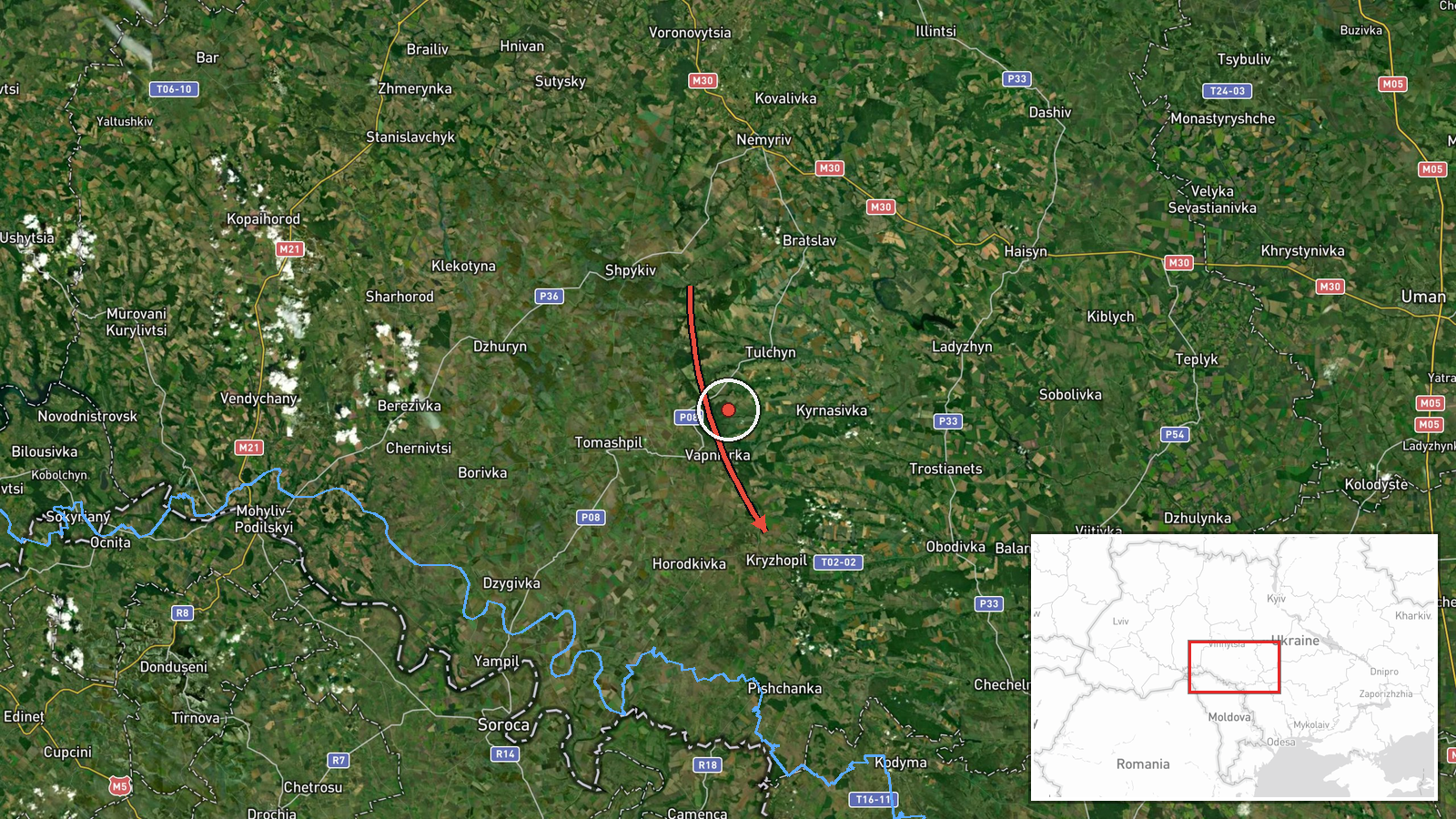
Ukrainian air monitoring reported on 20 October 2026 at 08:58 UTC a single Russian jet-powered Shahed, designated Geran-3, flying from Vinnytsia Oblast on a course toward Kryzhopil, a settlement in the south of the oblast. The original Ukrainian-language post describes a jet UAV in the Vinnytsia region heading for Kryzhopil. It does not report impact, damage, casualties or interception. The post is the only source logged for this entry. The wording 'курсом на' indicates direction of travel rather than a confirmed target. The event is a monitoring notice of a drone's track, not a confirmed strike, and it is one of several Shahed transit reports logged across southern and central Ukraine within the same 24-hour window.
Context and assessment
Kryzhopil lies in southern Vinnytsia Oblast, a region that Russian long-range drones have crossed repeatedly on routes toward western and southwestern Ukraine and toward the Odesa area. The Geran-3 is a jet-powered variant of the Shahed family. Its reported use suggests an effort to fly faster than the older piston-engine airframes, which can complicate interception by mobile fire groups. The related events show a pattern rather than an isolated track. On 19 October at 14:08 monitoring reported two or more drones from Vinnytsia Oblast toward Kryzhopil itself. On 20 October the feed logged further single drones moving through Odesa, Kirovohrad and Vinnytsia areas toward Rudnytsya, Bershad, Klembivka and southern Vinnytsia Oblast. Taken together, the sequence may indicate transit flights crossing several oblasts in a short period, possibly reflecting strikes on distant targets or routing that tests air defence coverage. These entries record direction, not outcome, so they should not be read as evidence of a specific target. The repeated mention of Kryzhopil over roughly eighteen hours suggests the town lies on a route used frequently, which later reporting should clarify.
Sources and confidence
This entry rests on a single Telegram channel, @kpszsu, which posts regular air-monitoring notices. No second channel, official statement or independent imagery has been logged for it, so cross-confirmation is absent. The confidence score of 8.0 reflects a channel with a consistent reporting format, a specific location and a clear track description, offset by the single source and the absence of outcome data. Confidence would rise with corroboration from another monitoring channel, a regional military administration statement or geolocated imagery. It would fall if later reporting contradicted the track or showed the drone was never in the area.
Location
Location is settlement-level: the entry names Kryzhopil and carries coordinates for the town, with high location confidence. The point marks the town, not a facility or impact site, and it does not imply the drone's position at any given moment. Kryzhopil sits in the southern part of Vinnytsia Oblast, in farmland near the boundary with Odesa Oblast. The wider Southern Bug river basin runs through this part of the region, broadly shaping the terrain and transit corridors.
Related events nearby
- Ukrainian air monitoring: 2+ Russian jet-powered Shahed (Geran-3) drones from Vinnytsia Oblast toward Kryzhopi2026-10-19 14:08 UTC · Drone Transit · Kryzhopil, Ukraine
- Ukrainian air monitoring: 1 Russian jet-powered Shahed (Geran-3) drone from Odesa Oblast toward Rudnytsya.2026-10-20 02:31 UTC · Drone Transit · Rudnytsya, Ukraine
- Ukrainian air monitoring: 1 Russian jet-powered Shahed (Geran-3) drone from Vinnytsia Oblast toward Klembivka.2026-10-20 06:57 UTC · Drone Transit · Klembivka, Ukraine
- Ukrainian air monitoring: 1 Russian jet-powered Shahed (Geran-3) drone from Odesa Oblast toward southern Vinny2026-10-20 06:48 UTC · Drone Transit · southern Vinnytsia Oblast, Ukraine
- Ukrainian air monitoring: 1 Russian jet-powered Shahed (Geran-3) drone from Kirovohrad Oblast toward Bershad.2026-10-20 04:32 UTC · Drone Transit · Bershad, Ukraine
▶ View this event on the live map

Intel Mapper aggregates open-source reports from monitored Telegram and X channels, geolocates them, cross-checks duplicates across sources and assigns a confidence score. Entries are updated as new confirmations arrive. Read how we verify events.